|
Contents Of This Report: |

|
National Drought Overview
|
|
[top]
Detailed Drought Discussion
Overview
November 2011 was warmer and wetter than average (25th warmest and 37th wettest, based on data back to 1895) when weather conditions are averaged across the country. But this reflected regional extremes in both monthly temperature and precipitation, as well as weekly regional patterns of temperature anomalies (weeks 1, 2, 3, 4) and precipitation anomalies (weeks 1, 2, 3, 4). Drought areas contracted slightly in the parts of the Central Plains and Mid-Mississippi Valley drought areas which received beneficial precipitation, but the precipitation had little effect on deficits that have accumulated over the last 12 months in the Plains and last 3 to 6 months in the Mid-Mississippi Valley. Drier-than-normal weather during November expanded drought in the Upper Mississippi Valley and Northern Plains, but the drought areas remained the same or contracted slightly in the Southeast and West. Rainfall over parts of Hawaii shrank the moderate to extreme drought area from 66 percent last month to 54 percent this month. Nationally, the moderate-to-exceptional drought footprint decreased to about 25 percent of the country and the percentage in the worst category (D4, exceptional drought) dropped to about 5 percent.

The U.S. Drought Monitor drought map valid November 1, 2011.
By the end of the month, the core drought areas in the U.S. included:
- a large area of moderate (D1) to exceptional (D4) drought across the Southwest, Southern and Central Plains;
- moderate to extreme drought in the Southeast;
- areas of expanding moderate to severe (D2) drought in the Upper Midwest to Northern Plains; and
- much of Hawaii, where moderate to extreme drought persisted.
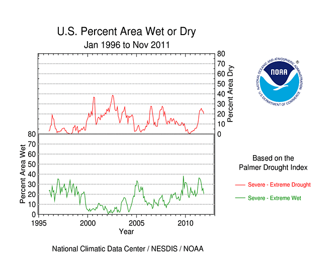
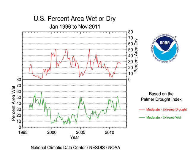
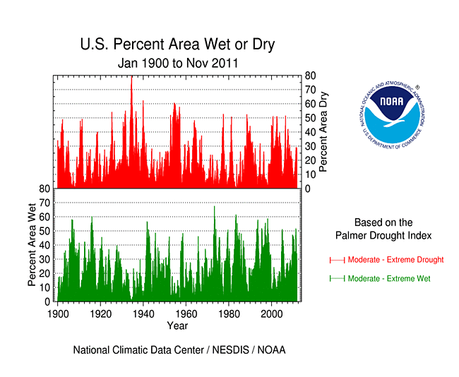
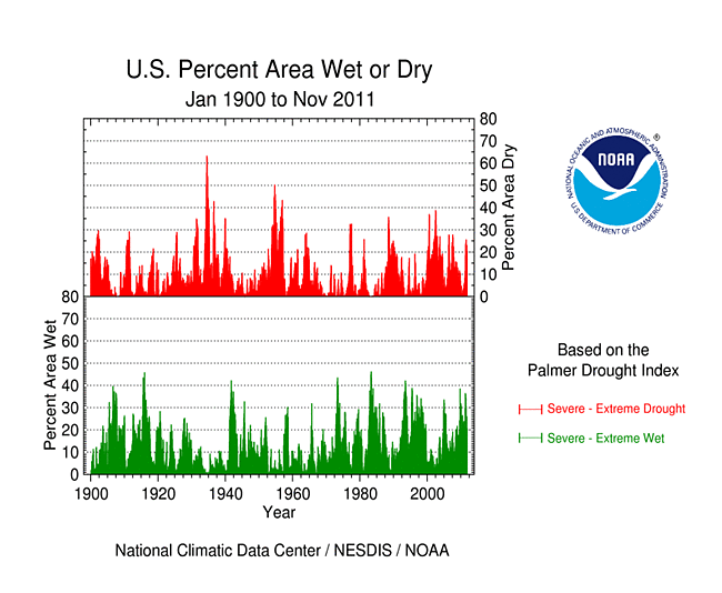
Palmer Drought Index
The Palmer drought indices measure the balance between moisture demand (evapotranspiration driven by temperature) and moisture supply (precipitation). The Palmer Z Index depicts moisture conditions for the current month, while the Palmer Hydrological Drought Index (PHDI) and Palmer Drought Severity Index (PDSI) depict the current month's cumulative moisture conditions integrated over the last several months.
|
 |
As seen on the November 2011 Palmer Z Index map, low precipitation led to short-term drought across the Upper Mississippi Valley, New England, and parts of the Northwest and Southern Plains this month. Wet conditions are evident on the Z Index map across the Ohio Valley to parts of the Central to Southern Plains. Compared with the October 2011 PHDI map, the November 2011 PHDI map indicates that drought conditions intensified in the Upper Mississippi Valley but decreased in intensity in parts of the Central Plains and Lower Mississippi Valley; wet conditions decreased in parts of the West and northern New England; and wet conditions increased in the Ohio Valley. The November 2011 PHDI map also reflects the long-term nature of the drought conditions. The Z Index and PHDI maps in combination show that precipitation brought relief to parts of the Central and Southern Plains drought area, near normal November moisture conditions occurred over much of the Southeast drought area, and moisture conditions further dried in parts of the Northwest and New England; but for the Ohio Valley, Upper Mississippi Valley, and extreme Southern Plains — precipitation fell where it was already wet and it was drier than normal over the existing drought areas.
Standardized Precipitation Index
The Standardized Precipitation Index (SPI) measures moisture supply. The SPI maps here show the spatial extent of anomalously wet and dry areas at time scales ranging from 1 month to 24 months.
 |
 |
 |
Dryness is evident in the Northern Plains and northern New England during November (1 month map), the Central Gulf Coast states and the climate divisions along the Rio Grande-Mexico border for the last 2 months, the Midwest to Upper Mississippi Valley, and the northwestern third of the country, at 1 to 6 months, the northwestern Great Lakes at 9 to 24 months, the Southwest to Southern Plains from 3 to 24 months, and the Southeast from 6 to 24 months. The Upper Mississippi Valley dryness is most severe at 3 months, and the Southwest to Southern Plains dryness is most severe at 6 to 12 months. Wet conditions caused by several frontal systems can be seen along the Central Plains to Ohio Valley at 1 to 2 months, spring and summer flooding are evident in the wetness from the Ohio Valley to Northeast at 6 to 9 months, and last winter's above-normal precipitation is still evident across the West at 12 months. This illustrates the persistence of the dry and wet areas.
 |
 |
 |
Agricultural and Hydrological Indices and Impacts
 |
 |
Drought conditions were reflected in numerous agricultural, hydrological, and other meteorological indicators, both observed and modeled. Across the drought areas of the Southeast, streamflows were low and many groundwater well stations were at or near record low levels for this time of year. Low streamflows also characterized the drought areas of the Southwest and Southern Plains, where soil moisture was depleted, water restrictions were implemented in many communities, and pastures, rangeland, crops, and natural vegetation were ravaged. Streamflow was low and soils dry in the Upper Mississippi and Western Great Lakes drought areas as well. Parts of the Southwest, Great Plains, and Upper Mississippi Valley had few, if any, days with precipitation in November. This summary is based on the following observed and modeled indicators:
hydrological:

USGS groundwater map.
- USGS (U.S. Geological Service) observed streamflow;
- NOAA Climate Prediction Center (CPC) modeled runoff anomalies and percentiles;
- VIC (University of Washington Variable Infiltration Capacity macroscale hydrologic model) 1-, 2-, 3-, and 6-month runoff percentiles;
- NLDAS (North American Land Data Assimilation System) modeled streamflow anomalies and percentiles;
- NLDAS model runoff anomalies and percentiles;
- USGS groundwater observations (real-time network, climate response network, total active network);
agricultural:

VegDRI (Vegetation Drought Response Index) map.
- the Palmer Crop Moisture Index (CMI), which still showed short-term agricultural drought in the Southern Plains, even though the growing season has ended across much of the country (weeks 1, 2, 3, 4);
- CPC modeled soil moisture anomalies and percentiles for end of November, soil moisture anomaly change;
- CPC's Leaky Bucket model soil moisture percentiles;
- NLDAS modeled soil moisture percentiles for the top soil layer and total soil layer;
- VIC modeled soil moisture percentiles, soil moisture percentile change;
- Vegetation Drought Response Index (VegDRI);
- the NESDIS satellite-based Vegetation Health Index (VHI);
meteorological:

Map of maximum consecutive dry days.
- total precipitation (plotted by the USGS, NOAA National Weather Service [NWS], and High Plains Regional Climate Center [HPRCC]);
- percent of normal precipitation and precipitation percentiles (NWS, HPRCC station observations, Leaky Bucket model, CPC);
- USGS number of days with precipitation and maximum number of consecutive dry days;
- temperature departures from normal (HPRCC, CPC) and percentiles (CPC, Leaky Bucket);
- number of record warm daily low temperatures, record daily high temperatures, record daily low temperatures, and record cool daily high temperatures set in November 2011 (from NCDC's daily records analysis).
![NOAA National Weather Service [NWS]](/img/climate/research/2011/nov/nws-ahps-pcp-amt-1130-us-1m.jpg)
![High Plains Regional Climate Center [HPRCC]](/img/climate/research/2011/nov/hprcc-pcp-amt-1130-us-1m.png)
Regional Discussion
November 2011 was a drier-than-normal month for many stations in the Hawaiian Islands. Above-normal rainfall on some islands shrank the percent of the state in moderate to extreme drought from 66 percent last month to 54 percent this month, but longer-term conditions remained drier than normal (last 2, 3, 6, 12, 24, 36 months), especially for the southern islands. November SPI values were consistently in the drought category for many locations, especially in Maui County, but streamflow was generally near normal.
Most stations in central and southern Alaska were drier than normal this month, continuing a trend which has dominated the last 2 to 3 months. The dryness is evident over the last three years (6, 12, 24, 36 months). Modeled soil moisture was drier than normal and November 30th snow water content (for stations and basinwide) was below normal at the interior locations, but some coastal locations were wetter than normal. Statewide, Alaska had the 41st driest November and 47th wettest autumn (September-November) in the 1918-2011 record, and there was no drought or abnormal dryness indicated on the November 29th USDM.
The southeastern third and northwestern corner of Puerto Rico were drier than normal during November. The dryness in the southeast was very evident at 2 months and still noticeable at 3 months, but disappears at longer time scales (6 months, and year to date). With streamflow near average, the November 29th USDM map had no drought or abnormally dry areas on the island.
 |
 |
On a statewide basis, November 2011 ranked in the top ten driest Novembers for Minnesota with two other states close behind (Maine at 11th driest and North Dakota at 12th driest). Nine other states (in New England, the Northern and Southern Plains, Southeast, and Far West) ranked in the driest third of the historical record. For the last three months (September-November 2011), prolonged dryness in the Upper Mississippi Valley ranked Minnesota third driest, South Dakota 13th driest, and Iowa 14th driest, while Texas ranked 13th driest and five other states (in the Upper Midwest, Central Great Plains, and Northwest) ranked in the driest third category. The dryness in the Southern Plains and Southeast lowered the ranks at longer time scales, with Texas ranking second driest, Georgia 11th driest, and New Mexico 12th driest, for June-November; thirteen other states (in the Southeast, Central Plains to western Great Lakes, and Northwest) ranked in the driest third category. Five states (New Mexico, Texas, Oklahoma, Louisiana, and Georgia) were in the top ten driest category for January-November and the last 12 months (December 2010-November 2011), with South Carolina close behind at 11th driest for both periods. Record dryness occurred for Texas at several time scales. Widespread and persistent dryness gave the Rio Grande and Texas Gulf Coast river basins the driest December-November in the 1895-2011 record.
 |
 |
During November, moderate to exceptional drought contracted to 72 percent of the South region, 42 percent of the Southeast region, 15 percent of the Midwest region, and 54 percent of Hawaii. It stayed about the same at 23 percent of the High Plains region and 19 percent of the West. Beneficial rains during the month shrank the worst drought category (D4, exceptional drought) in the South region from 42 percent last month to 29 percent this month, the second month in a row with decreasing exceptional drought area. Exceptional drought shrank from 65 percent to 53 percent for Texas, from 43 percent to 10 percent for Oklahoma, and from 26 percent to 18 percent for New Mexico. It dropped from 9 percent last month to 6 percent this month for the contiguous United States.
On a more localized basis, record dryness did not occur in any climate division during November, but record dryness did occur at a few climate divisions in the Upper Midwest and Deep South Texas during autumn (September-November) and in the Southern Plains at longer time scales (June-November, January-November, and December-November).

PHDI for Louisiana climate division 1 (Northwest), January 1900-November 2011.
The prolonged and intense drought conditions caused a rapid intensification of the PHDI, with several climate divisions reaching record dry PHDI values during the summer. Beneficial October and November rains backed off the PHDI values to only near-record intensity. While no longer record dry, the November 2011 PHDI values are still drier than any pre-2011 values for five climate divisions: northwest Louisiana (division 1), New Mexico's Southeastern Plains (division 7), and the Trans Pecos (division 5), High Plains (division 1), and East division (4) in Texas. These climate divisions mostly fall within the drainage basins of two river systems, the Rio Grande and the Texas Gulf Coast Basin.

Percent area of the Western U.S. in moderate to extreme drought, based on the Palmer Drought Index.
A large part of the West was drier than normal during November. The November and October precipitation patterns resulted in a dry start to the water year (October through the following September) for large areas from central Washington to central California and Nevada, as well as southern Arizona and New Mexico. Water-year precipitation was above normal across parts of the Northern and Central Rockies. This is evident in both low elevation and high elevation (SNOTEL) station data. Although total precipitation was above normal, more fell as rain than snow, resulting in below-normal snowpack moisture in many high elevation basins. The previous water year (October 2010-September 2011) left the West with moist conditions in the north and dry conditions in the south, as reflected in modeled soil moisture, PHDI, and streamflow, although conditions were drying out in recent months. An analysis of early data by the USDA indicated that reservoir levels were, on average, below normal in New Mexico but near to above average in most other western states. According to the USDM, 19 percent of the West was experiencing moderate to exceptional drought at the end of November, about the same as October, while the Palmer Drought Index statistic was about 14 percent, a decrease of about 1 percent. When the statistics for the Arizona-New Mexico-Colorado drought area (the Southwest drought area) are aggregated, the percent area in moderate to exceptional (USDM categories) drought has fluctuated between 60 and 70 percent for the last nine months. The percent area in the exceptional and extreme to exceptional categories steadily increased from March to June then leveled off with monsoon showers in July, then decreased slightly in August. The extreme to exceptional category has held steady at about 32 percent since then, while the exceptional drought area has decreased to about 6 percent at the end of this month.
A more detailed drought discussion, provided by the NOAA Regional Climate Centers and others, can be found below.
West — Upper Colorado River Basin — Pacific Islands
As noted by the Southeast Regional Climate Center, as in October, precipitation was highly variable across the Southeast during November. Monthly totals were between 150 and 200 percent of normal across northern portions of Alabama, Georgia, and South Carolina, and across western portions of North Carolina and Virginia. The driest locations in the Southeast were found across the southern two-thirds of Florida, where monthly precipitation totals were between 5 and 25 percent of normal. Daytona Beach, Florida recorded just 0.06 inch (1.5 mm) of precipitation, making it the second driest November in a record extending back to 1922. Elsewhere across the region, monthly precipitation was between 50 and 75 percent of normal, including the eastern slopes and interior mountains of Puerto Rico. Precipitation across the rest of the island was between 150 and 300 percent of normal. Mean temperatures in November were near normal across most of the region. The cold spell that occurred in the middle of the month resulted in trace amounts of snowfall across the higher elevations of western North Carolina and Virginia. Several locations across the interior of the region reported measurable snowfall from the 28th to the 30th of the month as an area of low pressure tracked through the Tennessee and Ohio River Valleys. Up to 3 inches (76.2 mm) of snow was reported in northern Alabama and western North Carolina, while Caesar's Head in northwestern South Carolina recorded just its fourth measurable November snowfall ever with 1 inch (25.4 mm) on the 30th of the month.
For the second consecutive month, there were very few changes to the USDM across the Southeast region. By the end of November, more than half of the region was classified as being in drought, with nearly two-thirds of Georgia still classified as being in extreme drought. At one point during the month, the water level at Lake Lanier in northern Georgia was dropping at a rate of one foot (304.8 mm) per week. According to the North Carolina State Climate Office, adequate topsoil moisture conditions aided in the successful planting of winter grains. In contrast, the Florida State Climate Office reported that the cold spell near the middle of the month damaged vegetable crops across the Florida Panhandle, while warm temperatures and dry weather increased disease pressures to crops in parts of south Florida.
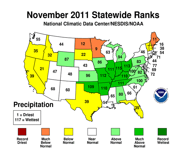
As explained by the Southern Regional Climate Center, November was generally a warmer-than-normal month for much of the Southern region and a wet month for much of the northern part of the region. Many stations in Oklahoma averaged between 150 and 300 percent of normal precipitation. This was also the case for central and northern Arkansas, and western and eastern Tennessee. For Oklahoma, it was the ninth wettest November on record (1895-2011), with a state average precipitation total of 4.87 inches (123.67 mm). Arkansas averaged 8.66 inches (219.964 mm) of precipitation, making it the eighth wettest November on record (1895-2011) there. Tennessee averaged 7.36 inches (186.94 mm), which was the seventh wettest November on record (1895-2011). Elsewhere in the Southern region, conditions were generally drier than normal. The driest areas included western and southern Texas, where the majority of stations received less than half the expected precipitation. This was also the case for the Florida parishes of Louisiana and the southern-most counties of Mississippi. Texas averaged only 1.24 inches (31.49 mm) of precipitation. Though it was drier than normal, it was still much wetter than in recent months. Conditions were slightly wetter in Louisiana and Mississippi, though still drier than normal. Louisiana and Mississippi reported state average precipitation totals of 3.64 inches (92.46 mm) and 3.71 inches (94.23 mm), respectively.
Drought conditions in the Southern region did not change much in terms of extent; however, there were significant improvements in terms of intensity. In total, the region saw approximately a ten percent reduction in areal extent of each drought category. This equates to a one category improvement over much of the region. Exceptional drought, which last month covered over 40 percent of the region, was reduced to just under 30 percent. Drought conditions were removed in western Tennessee, and much of Arkansas was now drought-free. Some new moderate drought crept into southern Mississippi, but deterioration of drought conditions this month was fortunately minimal.
As summarized by the Midwest Regional Climate Center, November temperatures were above normal across the Midwest, but precipitation ranged widely. Parts of Minnesota and northwest Iowa received less than 0.10 inch (3 mm) and amounts increased to the south and east with the boot heel of Missouri and western Kentucky topping 10 inches (254 mm) for the month. Totals were near twice normal or more in swaths across northern Missouri to western Illinois and from the boot heel of Missouri up the Ohio River Valley and northward to western Lake Erie. Fall precipitation also ranged widely across the region. Three-month totals ranged from under 2 inches (51 mm) to nearly 20 inches (508 mm).
Drought conditions in the Midwest shifted to the west and north during November, continuing the migration seen in the fall season as a whole. November rains in Missouri, Illinois, and southeast Iowa led to improvements, or elimination, of drought conditions while dry conditions to the northwest led to degradations in Minnesota and northwest Iowa where Severe Drought designated areas expanded during the month.
Wet areas in the eastern half of the Midwest saw no relief as heavy rains fell in November. Harvest in Ohio was behind schedule due to wet soils and continued rains. Minor to moderate flooding was reported in Indiana, Ohio, and Kentucky late in the month. Cincinnati's airport station has already set an annual (calendar year) record precipitation total of 66.76" (1695 mm) with a month left in the year. The total is 27.72 inches (704 mm) above normal and already 9.18 inches (233 mm) above the old record from 1990. Records for the station extend back to 1869. Several nearby Kentucky stations are near their annual records as well.
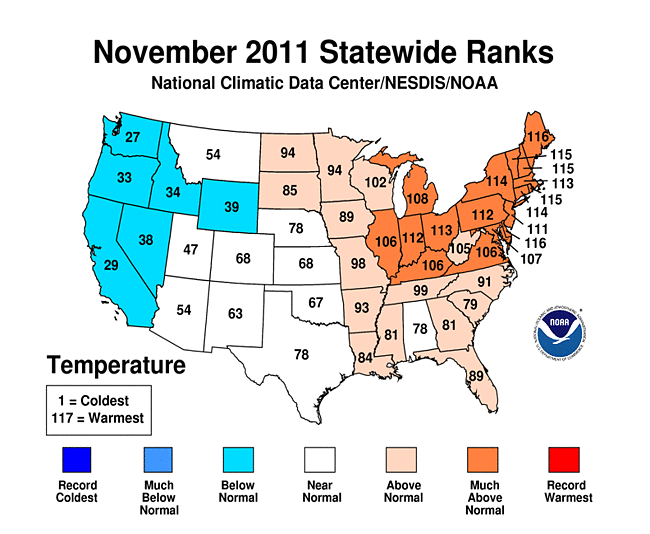
As noted by the Northeast Regional Climate Center, November's temperatures averaged 44.0 degrees F (6.7 degrees C), making this the third warmest November in the Northeast since 1895. It was the eleventh consecutive month with above normal temperatures. Each of the states in the region had averages that were within the top 14 warmest in 117 years. Delaware and Maine ranked 2nd warmest, while New Hampshire, Rhode Island and Vermont saw their 3rd warmest November since 1895. It was the 4th warmest autumn (September - November) in the Northeast since 1895, with three states (Massachusetts, Rhode Island, and Vermont) having their warmest autumn in 117 years.
After three wetter-than-normal months, precipitation totals averaged on the dry side in November. The Northeast total of 3.20 inches (81.3 mm) was 84 percent of normal. New Jersey (106 percent), Pennsylvania (103 percent) and West Virginia (122 percent) were the only states with above normal totals. Departures in the drier-than-normal states ranged from 48 percent of normal in Maine to 99 percent of normal in Delaware. It was the 11th driest November in Maine since recordkeeping began in 1895. Autumn (September - November) precipitation totals averaged 14.69 inches (373 mm), which was 127 percent of normal. The Northeast saw its fifth wettest autumn in 117 years; with 18.25 inches (464 mm), Pennsylvania saw its wettest autumn on record. West Virginia's three-month total of 15.08 inches (383 mm) made this the 2nd wettest autumn since 1895 and Maryland's total of 16.96 inches (431 mm) ranked 3rd wettest on record. Six states (Connecticut, Massachusetts, New Jersey, New York, Pennsylvania, and Vermont) and the region overall saw their wettest January through November in 117 years.
As explained by the High Plains Regional Climate Center, overall, the High Plains region experienced a warm and dry November. These conditions were favorable for crop producers and allowed most of the remaining harvesting activities across the region to be completed. The largest temperature departures were in the Dakotas, northern Nebraska, and pockets of eastern Colorado. In these areas, temperatures were generally 4-6 degrees F (2.2-3.3 degrees C) above normal. Below normal temperatures were confined to western Wyoming and a few isolated locations throughout the region.
November 2011 was drier than normal for most of the region. Many locations in North Dakota, South Dakota, and a swath running from southwest to northeast Nebraska received less than 25 percent of normal precipitation. According to the U.S. Drought Monitor, the ongoing lack of precipitation caused moderate drought conditions to spread into eastern North Dakota, eastern South Dakota, and northern Nebraska. Additionally, abnormally dry conditions spread across North Dakota and into parts of western South Dakota. For many locations, this autumn (September, October, and November) was one of the driest on record. One of the many locations to set records this autumn was Sioux Falls, South Dakota which only received 0.87 inch (22 mm) over the three month period. To put this amount into perspective, the normal precipitation for autumn in Sioux Falls is 6.30 inches (160 mm). The old record for driest autumn occurred in 1952 with 1.02 inch (26 mm) of precipitation (period of record 1893-2011). There were some exceptions to the dryness this month. Central Wyoming, southern and eastern Kansas, and the southeastern corner of Colorado all received at least 150 percent of normal precipitation. The precipitation was a welcome sight in the drought impacted areas of Kansas and Colorado. Heavy rains occurred November 7-8 in southern and eastern Kansas. During this time many daily precipitation records were set and, when combined with the rest of the month, the precipitation helped many locations to be ranked in the top 10 wettest Novembers on record. Topeka, Kansas received 2.98 inches (76 mm) over the two-day period, which included 2.05 inches (52 mm) on the 7th alone. This amount crushed a long-standing daily precipitation record of 1.43 inches (36 mm) set in 1918 (period of record 1887-2011). By the end of the month, Topeka had received 4.66 inches (118 mm) of precipitation which was the 8th wettest November on record. It is interesting to note that on average, November is usually one of the driest months of the year; however, this November was the second wettest month of 2011 in Topeka.
The USDM had many changes this month. Beneficial rains across southern and eastern Kansas led to one-category improvements for much of the drought stricken area. Additional improvements were made in south-central Colorado as two areas of extreme drought (D3) were downgraded to severe drought (D2). Only a small area of exceptional drought remained in southwest Kansas and the far southeast corner of Colorado. Nebraska and the Dakotas all had degradations, as precipitation totals were well below normal. Abnormally dry conditions (D0) spread across southern North Dakota and into northwestern South Dakota. Moderate drought (D1) spread south through eastern Nebraska and also developed in eastern North Dakota. According to the North Dakota State Climate Office, before the introduction of D1 this month, the state had gone 115 consecutive weeks with no drought. D2 spread into northeastern Nebraska and east-central South Dakota as well.
As summarized by the Western Regional Climate Center, several strong, deep troughs passed through the West this month, bringing cold Arctic air and slightly below to well below normal temperatures to areas west of the Rockies. The associated storm systems, however, generally resulted in precipitation values that were below normal. In part, the trajectories of these storms left many of them with insufficient moisture to produce typical November precipitation. Consequently, dry conditions dominated in the West this month. The Reno, Nevada airport tied its 7th driest November in a record beginning in 1937 with a precipitation total of 0.06 inch (1.52 mm). In central Oregon, the Redmond airport station also recorded its 7th driest year on record, with 0.21 inch (5.3 mm). Many eastern Oregon and Washington locations received only 50-75 percent of their normal precipitation amounts. Albuquerque, New Mexico had its 29th driest year on record, receiving 0.13 inch (3.3 mm).
Pockets of above-normal precipitation appear in the usually dry Southwest due to cutoff low systems that passed through the area this month. The much-needed precipitation from these systems helped to reduce the severity of the drought in western Arizona, though severe drought persisted in New Mexico. Wyoming also experienced pockets of above normal precipitation.
Upper Colorado River Basin: As reported by the Colorado Climate Center, the November 29th NIDIS (National Integrated Drought Information System) assessment for the Upper Colorado River Basin (UCRB) indicated that generous amounts of precipitation fell throughout the UCRB in November. Water-year-to-date (WYTD) SNOTEL precipitation percentiles were in the near- to above-average range throughout most of the UCRB, with the lowest percentiles (between the 30th and 50th percentiles) in the Gunnison River basin. As of November 27th, 88 percent of the USGS streamgages in the UCRB had normal (25th-75th percentile) or above normal 7-day average streamflows. About 14 percent of the gages in the basin had much above normal flows, while 11 percent were below normal. Most of the gages recording below normal flows were located in the southern part of the UCRB (in the San Juan basin). The VIC model continued to show dry soil moisture conditions in southeast Colorado. Dry soil conditions were showing up in Utah around the Colorado River valley and deteriorated in Sweetwater County, Wyoming. Wet soils were in the northern Colorado mountains and eastward. All of the major reservoirs above Lake Powell were near or above their November averages. Dillon, Green Mountain, Granby, and Lake Powell have all seen 2 percent or greater drops in levels this month. Flaming Gorge and Blue Mesa Reservoirs have only slight decreased, while Navajo has stayed at a nearly steady level for the month. Lake Powell was at 87 percent of average and 69 percent of capacity, compared to 61 percent of capacity one year ago.
Pacific Islands: According to reports from National Weather Service offices, the Pacific ENSO Applications Climate Center (PEAC), and partners, conditions varied across the Pacific Islands.
As noted by the National Weather Service office in Honolulu, persistent trade wind conditions during November helped bring near to above normal rainfall totals to many of the windward slopes of the main Hawaiian Islands. However, the persistent trades meant little rainfall occurred over leeward areas. On the Big Island, extreme drought, or D3 category conditions on the USDM map, in the south Kohala district and leeward north Kohala district spread into the Pohakuloa region of the Hamakua district. Extreme drought also continued over the southern portion of the Kau district. Severe drought, or D2 category conditions, remained over most of the north Kona district and over the mid-section of the Big Island from Pohakuloa to Kau. Wet windward conditions resulted in a retreat of moderate drought, or D1 category conditions, away from the lower elevations. On the island of Maui, early November rainfall provided some drought relief to the southeast slopes of Haleakala from Kepuni to Kaupo. However, extreme drought continued along the southwest Haleakala slopes from Kamaole to Ulupalakua. Elsewhere in Maui County, severe drought persisted over the lower elevations of west Maui from Maalaea through Lahaina and over the western third of Molokai. Heavy rainfall during the first half of November brought some drought relief to Kauai which went from severe drought to moderate drought over the Kalepa area near Lihue. The drought classification in east Oahu worsened to the severe category due to diminishing water levels in the Waimanalo reservoir. West Oahu stayed in the moderate drought category. Severe drought has affected portions of the state of Hawaii continuously since June 2008.
Some drought impacts in Hawaii include the following:
- On Kauai, November rainfall helped improve pasture conditions in east Kauai.
- On Oahu, the water level in the Waimanalo reservoir continued to decrease and has dropped over 40 feet since mid-May. The State of Hawaii Department of Agriculture implemented stricter conservation measures on November 18 and set a mandatory 20 percent cutback in irrigation water use.
- On Molokai, the State of Hawaii Department of Agriculture has kept in place the mandatory 30 percent cutback in irrigation water consumption for the Kualapuu reservoir system.
- On Lanai, no significant changes since the November 3 update. No additional impact information has been received.
- On Maui, pastures and general vegetation remained dry over the leeward slopes of Haleakala especially from Kamaole to Ulupalakua. Water supply levels for upcountry Maui have improved since October due to an increase in windward Haleakala rainfall. However, the Maui County Department of Water Supply has maintained their call for a 5 percent reduction in water use. The request for a 10 percent reduction in water use by central and south Maui residents also remained in effect.
- On the Big Island, pastures and general vegetation from Kawaihae to north Kona and from South Point to Pahala were in very poor condition and brush fires continued to be a significant concern. Many ranchers have already destocked cattle and water hauling operations have been ongoing for several months. A rancher recently reported having to sell replacement heifers which will result in a long-term impact. In September the USDA Farm Service Agency reported that various areas of the island had 30 to 100 percent loss of forage for livestock. Coupled with higher feed prices, the impact on ranching operations has been significant. In the south Kona district, yields for a wide range of fruit have decreased due to ongoing drought conditions.

On other Pacific Islands, November was drier than normal in Guam and Kosrae and moderately dry at Saipan and Koror, but near to above normal at most other locations.
| Station Name | Dec 2010 | Jan 2011 | Feb 2011 | Mar 2011 | Apr 2011 | May 2011 | Jun 2011 | Jul 2011 | Aug 2011 | Sep 2011 | Oct 2011 | Nov 2011 | Dec 2010-Nov 2011 |
| Chuuk | 85% | 76% | 137% | 156% | 109% | 66% | 218% | 124% | 147% | 120% | 80% | 135% | 119% |
| Guam IAP | 76% | 205% | 166% | 138% | 142% | 95% | 96% | 195% | 109% | 121% | 128% | 75% | 126% |
| Kapingamarangi | 9% | 22% | 2% | 61% | 74% | 69% | 247% | 199% | 214% | 181% | 111% | 76% | 92% |
| Koror | 75% | 163% | 145% | 170% | 130% | 180% | 129% | 166% | 145% | 269% | 107% | 61% | 144% |
| Kosrae | 76% | 82% | 67% | 51% | 74% | 151% | 114% | 76% | 105% | 86% | 104% | 82% | 89% |
| Kwajalein | 37% | 119% | 316% | 277% | 49% | 91% | 121% | 100% | 135% | 101% | 122% | 137% | 118% |
| Majuro | 95% | 100% | 190% | 188% | 28% | 109% | 97% | 118% | 106% | 108% | 107% | 125% | 110% |
| Pago Pago | 92% | 183% | 110% | 52% | 36% | 35% | 132% | 40% | 60% | 26% | 126% | 143% | 92% |
| Pohnpei | 75% | 98% | 125% | 148% | 47% | 95% | 128% | 85% | 120% | 97% | 72% | 124% | 99% |
| Saipan | 43% | 182% | 124% | 164% | 209% | 154% | 174% | 110% | 120% | 64% | 131% | 51% | 112% |
| Yap | 69% | 164% | 123% | 171% | 129% | 169% | 113% | 157% | 133% | 155% | 101% | 109% | 132% |

[top]
State/Regional/National Moisture Status
A detailed review of drought and moisture conditions is available for all contiguous U.S. states, the nine standard regions, and the nation (contiguous U.S.):
| northeast u. s. | east north central u. s. | central u. s. |
| southeast u. s. | west north central u. s. | south u. s. |
| southwest u. s. | northwest u. s. | west u. s. |
| Contiguous United States |
[top]
Drought Indicators
- Palmer Drought Indices
- Standardized Precipitation Index
- long-term (36 to 60 month) percent of normal precipitation maps
- airport station percent of normal precipitation maps
- statewide precipitation rank maps
- Cooperative station percent of normal precipitation maps
- percent of average maps for the SNOTEL stations in the western mountains provided by the Western Regional Climate Center
- hydrologic year precipitation
- snow water equivalent of snowpack
- satellite-based observations of vegetative health
- National Weather Service model calculations of soil moisture, runoff, and evaporation
- National Weather Service model calculations of soil moisture using the Leaky Bucket Model
- Midwest Regional Climate Center model calculations of soil moisture
- topsoil moisture conditions observed by the USDA and mapped by the Climate Prediction Center
- pasture and range land conditions observed by the USDA and mapped by the Climate Prediction Center
- streamflow maps maintained by the USGS
[top]
Contacts & Questions