|
Contents Of This Report: |

|
National Drought Overview
|
|
[top]
Detailed Drought Discussion
Overview
September 2011 was a warm month with near-average precipitation (eleventh warmest and 50th driest, based on data back to 1895) when weather conditions are averaged across the country. But this reflected regional extremes (in both monthly temperature and precipitation) which resulted from persistent weekly regional patterns of temperature anomalies (weeks 1, 2, 3, 4, 5) and variable weekly regional patterns of extreme precipitation anomalies (weeks 1, 2, 3, 4, 5). Heavy rain from Tropical Storm Lee early in the month cut a swath from the Central Gulf Coast to the Northeast, severing the Southeast drought area from the Southern Plains drought area and improving conditions along the edge of the rain shield. The percent area in moderate to exceptional drought (D1-D4) dropped from 55 percent at the end of August to 42 percent at the end of September for the Southeast, and from 86 percent to 76 percent for the South. But little change occurred in the extreme to exceptional (D3-D4) drought categories: the South coverage was 64 percent at the end of September and the Southeast coverage was 23 percent. Very little change occurred in drought coverage of the Southwest (Arizona, New Mexico, and Colorado), where moderate-to-exceptional drought coverage remained about 65 percent, with extreme to exceptional coverage at a steady 31 percent. In Hawaii, moderate to exceptional drought coverage hovered around 45 percent, but severe to exceptional (D2-D4) drought coverage jumped from 5 percent at the end of August to 15 percent at the end of September. Nationally, the moderate-to-exceptional drought footprint covered about a fourth of the country, but about a tenth of the U.S. remained in the worst category (D4, exceptional drought), which has been fairly constant since early summer. Two areas of the southern U.S. experienced the most severe drought in the 1900-present record, according to the Palmer Hydrological Drought Index (PHDI). The two regions having the most severe PHDI on record are eastern New Mexico into western Texas and southwest Oklahoma, and northwestern Louisiana into adjacent eastern Texas. These two regions accounted for 4.2 percent, by area, of the country.

The U.S. Drought Monitor drought map valid September 27, 2011.
By the end of the month, the core drought areas in the U.S. included:
- a large area of moderate (D1) to exceptional (D4) drought across the Southwest, Southern and Central Plains;
- areas of moderate to extreme drought in the Southeast;
- areas of moderate to severe (D2) drought in the Midwest; and
- parts of Hawaii, where moderate to severe drought persisted.
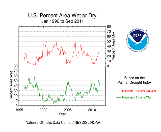
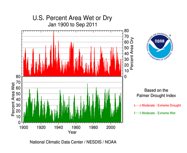
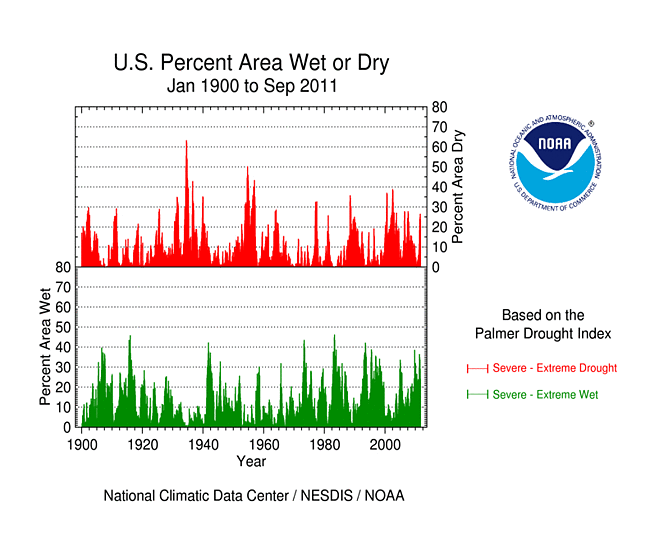
Palmer Drought Index
The Palmer drought indices measure the balance between moisture demand (evapotranspiration driven by temperature) and moisture supply (precipitation). The Palmer Z Index depicts moisture conditions for the current month, while the Palmer Hydrological Drought Index (PHDI) and Palmer Drought Severity Index (PDSI) depict the current month's cumulative moisture conditions integrated over the last several months.
|
 |
As seen on the September 2011 Palmer Z Index map, low precipitation and above-normal evapotranspiration due to above-normal temperatures led to short-term drought across the Southern Plains, southern Florida, and the Northwest to Northern Rockies this month. Temperatures were not a factor in the Central Plains to Upper Mississippi Valley, but below-normal precipitation resulted in short-term dryness there. Wet conditions are evident on the Z Index map over a large area from the Mid-Gulf Coast to the Northeast where moisture from Tropical Storm Lee fell. Compared with the August 2011 PHDI map, the September 2011 PHDI map indicates that drought conditions intensified in the Southern Plains; drought conditions improved in the Mid-Gulf Coast States; moist conditions decreased in the Pacific Northwest and parts of the Midwest to western Great Lakes; and moist conditions increased in the Ohio Valley to Northeast. The September 2011 PHDI map also reflects the long-term nature of the drought conditions. The Z Index and PHDI maps in combination show that tropical rains brought relief to the Mid-Gulf Coast drought areas, and dry weather dried out parts of the Northwest, Northern Rockies, and Midwest, but for the Southern Plains and Northeast — it rained where it was already wet and was drier than normal over the existing drought areas.
Standardized Precipitation Index
The Standardized Precipitation Index (SPI) measures moisture supply. The SPI maps here show the spatial extent of anomalously wet and dry areas at time scales ranging from 1 month to 24 months.
 |
 |
 |
Dryness is evident across much of the Great Plains to western Great Lakes during September (1 month map), and across the Northwest to Northern High Plains and parts of the Midwest at 1 to 3 months. The Southwest, Southern Plains, and Southeast dryness can be seen at all time scales from 2 to 24 months, but is most severe at 6, 9, and 12 months. Wet conditions caused by Tropical Storm Lee moisture can be seen at 1 month, and the flooding spring rains in the Midwest and Northern Plains show up at 6 and 9 months. In addition to the Northern Plains and Midwest to Northeast wetness, the usually wet conditions from last winter across much of the West are evident in the 12- and 24-month time scales. This illustrates the persistence of the dry and wet areas.
 |
 |
 |
Agricultural and Hydrological Indices and Impacts
 |
 |
Drought conditions were reflected in numerous agricultural, hydrological, and other meteorological indicators, both observed and modeled. Across the drought areas of the Southwest, Southern Plains, and Southeast, streamflows were low, some groundwater well stations were at or near record low levels for this time of year, soil moisture was depleted, water restrictions were implemented in many communities, and pastures, rangeland, crops, and natural vegetation were ravaged. Dry soils were widespread across the Great Plains and Rockies States and into the Northwest. Low soil moisture and stream levels and stressed vegetation were observed across parts of the western Great Lakes. Much of the Far West, Great Plains, and Northern Rockies had few, if any, days with rain in September. A large area of dry soils was indicated for Mexico connected to the Southern Plains dryness, and dry soils in the western Great Lakes extended into Canada. Above-normal temperatures coupled with the subnormal precipitation placed additional stress on vegetation in the West and Southern Plains. This summary is based on the following observed and modeled indicators:
hydrological:

USGS groundwater map.
- USGS (U.S. Geological Service) observed streamflow;
- NOAA Climate Prediction Center (CPC) modeled runoff anomalies and percentiles;
- VIC (University of Washington Variable Infiltration Capacity macroscale hydrologic model) 1-, 2-, 3-, and 6-month runoff percentiles;
- NLDAS (North American Land Data Assimilation System) modeled streamflow anomalies and percentiles;
- NLDAS model runoff anomalies and percentiles;
- USGS groundwater observations (real-time network, climate response network, total active network);
agricultural:

VegDRI (Vegetation Drought Response Index) map.
- USDA (U.S. Department of Agriculture) observed soil moisture conditions, departures and percentiles, and comparison to 5-year average and 10-year average;
- the Palmer Crop Moisture Index (CMI), which showed short-term agricultural drought in the South and Northwest, but decreased in intensity as the season transitioned further into autumn (weeks 1, 2, 3, 4, 5);
- CPC modeled soil moisture anomalies and percentiles for end of September, soil moisture anomaly change;
- CPC's Leaky Bucket model soil moisture percentiles;
- NLDAS modeled soil moisture percentiles for the top soil layer and total soil layer;
- VIC modeled soil moisture percentiles;
- USDA observed pasture and rangeland conditions;
- Vegetation Drought Response Index (VegDRI);
- the NESDIS satellite-based Vegetation Health Index (VHI);
- the USGS agro-hydrologic model (Soil Water Index, Water Requirement Satisfaction Index);
meteorological:

Map of maximum consecutive dry days.
- total precipitation (plotted by the USGS and NOAA National Weather Service [NWS]);
- percent of normal precipitation and precipitation percentiles (NWS, High Plains Regional Climate Center station observations, Leaky Bucket model, CPC);
- USGS number of days with precipitation and maximum number of consecutive dry days;
- temperature departures from normal and percentiles (CPC, Leaky Bucket);
- number of record warm daily low temperatures, record daily high temperatures, record monthly high temperatures, and all-time record high temperatures set in September 2011 (from NCDC's daily records analysis).
![NOAA National Weather Service [NWS]](/img/climate/research/2011/sep/nws-pcp-amt-1001-us-sep11.jpg)
Regional Discussion
September 2011 was a drier-than-normal month for most of the stations in the Hawaiian Islands. About 45 percent of the state was classified in the moderate to exceptional drought categories at the end of September, about the same as at the end of August. However, severe to exceptional (D2-D4) drought coverage jumped from 5 percent at the end of August to 15 percent at the end of September, and virtually all of the state (95 percent) was classified in the D0-D4 categories (abnormally dry to exceptional drought) at the end of September compared to 75 percent at the end of August. Streamflow was below normal and long-term rainfall deficits remained at most time scales (last 2, 3, 6, 12, 24, 36 months), especially for the southern islands.
Many stations in southern Alaska (except the panhandle) were drier than normal during September, and dryness remained at longer time scales (2, 3, 6, 12, 24, 36 months). The September 30th snow water content was below normal, but this is early in the season and the snow depth amounts this time of year are typically low. Although September 2011 ranked as the 26th driest September in the 1918-2011 record, July-September 2011 ranked 29th wettest, so there was no drought or abnormal dryness indicated on the September 27th USDM.
The precipitation pattern for Puerto Rico was mixed during September. Above-normal rainfall dominated at longer time scales (2, 3, and 6 months, year to date, and water year [October-September]), and streamflow was above average, so the September 27th USDM map had no drought or abnormally dry areas on the island.
![water year [October-September]](/img/climate/research/2011/sep/nws-pcp-pct-0930-pr-wytd.jpg)
 |
 |
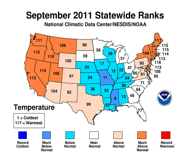
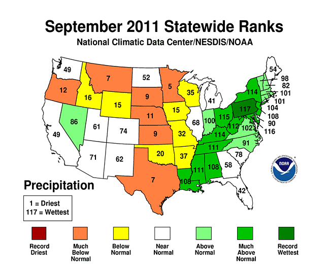
On a statewide basis, September 2011 ranked in the top ten driest Septembers for five states in the Great Plains and Northern Rockies, top ten wettest for eleven states from the Gulf Coast to Northeast, and wettest on record for Pennsylvania. Nine other states (in the northwestern and central parts of the country) ranked in the dry third of the historical record for September. July-September 2011 ranked in the top ten driest category for seven states in the Northwest, Southern Plains, and Southeast. Record to near-record dryness occurred for Texas, Oklahoma, and New Mexico at several other time scales (April-September; year-to-date [January-September]; and last 12 months [October 2010-September 2011]). For Texas, every time period from the last four months to last twelve months (June-September 2011 back to October 2010-September 2011) ranked driest on record, while Oklahoma ranked first or second driest and New Mexico first to fourth driest for those time periods. Louisiana had the driest December-September in the 117-year record and Florida, Georgia, and South Carolina each ranked fourth driest for October-September. Widespread dryness in the Rio Grande and Texas Gulf Coast basins has resulted in the driest water year (October-September) for those river basins, with the Arkansas-White-Red Basin ranking second driest and South Atlantic-Gulf Basin ranking tenth driest. In contrast, the Mid-Atlantic and New England basins ranked third wettest for October 2010-September 2011, with the last eight to nine years consistently much wetter than normal. The record dryness in the Southern Plains was accompanied by record heat statewide for Texas, Oklahoma, and New Mexico (July-September, April-September, and January-September).
![year-to-date [January-September]](/img/climate/research/2011/sep/st-p-Statewideprank-201101-201109.gif)
 |
 |
 |
During September, exceptional drought (the worst USDM category) expanded to 55 percent of the South region, which is the largest such extent in the 11-year history of the USDM. Exceptional drought afflicted 88 percent of Texas and 69 percent of Oklahoma in September, also USDM records. The number held steady at a record 11 to 12 percent for the contiguous United States.
On a more localized basis, record dryness has occurred for at least one climate division in the Southwest, Southern Plains, Southeast, or Northwest at every time scale from September 2011 through the 12-month period, October 2010-September 2011. Record warm temperatures have occurred for at least one climate division during all of the last 12 time periods or "seasons" (September 2011 back through October 2010-September 2011), especially in the Southern Plains during the spring and summer:
|
|
|
The prolonged and intense drought conditions have caused a rapid intensification of the PHDI, with the September 2011 PHDI at record low values for several climate divisions in the Southwest to Lower Mississippi Valley (reliable PHDI records go back to January 1900). There were two epicenters of record low PHDI values — one from eastern New Mexico into western Texas and southwest Oklahoma, and the other from northwestern and central Louisiana into adjacent eastern Texas. The climate divisions with record low PHDI values include:
|
|
|
The PHDI reached record intensity during 2011 in Louisiana climate divisions 2 and 4, New Mexico climate divisions 6 and 7, Texas climate division 1, on a statewide basis in Texas, and in the Rio Grande and Texas Gulf Coast river basins. In all of these cases, even though the intensity of the current drought is record or near-record, the duration of earlier droughts exceeds the duration of the current drought.
 |
 |
 |
 |

Percent area of the Western U.S. in moderate to extreme drought, based on the Palmer Drought Index.
The West was generally drier than normal in September, but a few areas were wetter than average. This did little to change the overall pattern for the water year (October-September) — extremely dry conditions have been persistent from Arizona and New Mexico into southern Colorado, but abundant precipitation has fallen across the rest of the West. This is evident in both the low elevation station precipitation as well as the high elevation (SNOTEL) station precipitation, modeled soil moisture, and PHDI. An analysis of early data by the USDA indicated that reservoir levels were, on average, above normal in most western states. September 30th snow water content at the higher elevation SNOTEL stations was much above normal, but this is early in the snow season when snow cover is just becoming established and normals are low. According to the USDM, 19 percent of the West was experiencing moderate to exceptional drought at the end of September, about the same as August, while the Palmer Drought Index statistic was about 16 percent, an increase of about 2 percent. When the statistics for the Arizona-New Mexico-Colorado drought area (the Southwest drought area) are aggregated, the percent area in moderate to exceptional (USDM categories) drought has fluctuated between 60 and 70 percent for the last seven months. The percent area in the exceptional and extreme to exceptional categories steadily increased from March to June then leveled off with monsoon showers in July, then decreased slightly in August, holding steady at about 31 percent in extreme to exceptional drought at the end of this month.
A more detailed drought discussion, provided by the NOAA Regional Climate Centers and others, can be found below.
West — Upper Colorado River Basin — Pacific Islands
As noted by the Southeast Regional Climate Center, as in August, monthly precipitation during September 2011 was generally below normal across the Southeast, except in areas affected by tropical cyclone activity. Tropical Storm Lee dropped between 8 and 13 inches (203.2-330.2 mm) of rain across central Alabama, northwest Georgia, western North Carolina, and much of Virginia from the 3rd to the 9th of the month. Major flooding was reported along several rivers and creeks across central and southern Alabama. On the 12th and 13th of the month, Hurricane Maria dropped up to 10 inches (254.0 mm) of rain across Puerto Rico, triggering several landslides along the eastern slopes of the island. The driest locations across the Southeast (less than 50 percent of normal) were found across eastern North Carolina, southern Georgia, and portions of northern Florida. Mean temperatures in September ranged from 1-4 degrees F (0.5-2.2 degrees C) below average across Alabama, Georgia, and the Florida Panhandle to 1-3 degrees F (0.5-1.6 degrees C) above average across Virginia, the Carolinas, and the Florida Peninsula. Monthly temperatures were below average across Puerto Rico and the U.S. Virgin Islands.
The beneficial rain from Tropical Storm Lee helped eliminate several areas of drought across the western and northern fringes of the region. In particular, areas of severe drought (D2) were eliminated across southern Alabama and northwest Georgia. Conversely, the region of extreme drought (D3) expanded into parts of northern South Carolina. Reservoir levels continued to fall across parts of Georgia, where rainfall deficits have been the greatest, and water restrictions were implemented in several more communities in the southern part of the state.
As explained by the Southern Regional Climate Center, September precipitation totals in the Southern region varied dramatically from west to east. Conditions were quite dry in Texas, Oklahoma and Arkansas, with most stations reporting only between 5 to 50 percent of normal. By contrast, conditions were quite wet in Tennessee, Mississippi, and Louisiana, with a bulk of stations reporting between 150 to 200 percent of normal precipitation. This was primarily due to Tropical Storm Lee, which stalled off the Gulf Coast in the early part of the month and eventually made its way inland across the eastern half of the Southern region. The storm dumped copious amounts of rainfall. Areas within the Florida parishes of Louisiana reported up to 10 inches (254.00 mm) of rainfall, however, most of the values reported in the Southern region varied from 3 to 7 inches (76.20 to 177.80 mm). By month's end, Louisiana recorded a state average precipitation value of 6.93 inches (176.60 mm). This equates to the tenth wettest September for the state on record (1895-2011). Both Mississippi and Tennessee reported their seventh wettest September on record (1895-2011). Mississippi averaged 7.67 inches (194.82 mm) for the month, while Tennessee averaged 6.73 inches (170.94 mm) for the month. Drought ridden Texas remained dry for the month. The state averaged 1.08 inches (27.43 mm), which is the first time since May that the state averaged more than an inch of precipitation. However, it was still the seventh driest September on record (1895-2011) for the state. For Oklahoma, it was the twentieth driest September on record (1895-2011) with a state average precipitation value of 1.72 inches (43.69 mm). Arkansas experienced its 37th driest September on record (1895-2011) with a state average precipitation value of 2.63 inches (66.81 mm). With the exception of Texas, fall in the Southern region began as a contrast to the past several months, in that most of the region experienced cooler than normal temperatures.
Due to dry conditions in Arkansas, Oklahoma and Texas, drought conditions changed very little over the western half of the Southern region in the past month. Approximately 53 percent of the region remained in exceptional drought, most of which was Texas and western and central Oklahoma. Exceptional drought also persisted in northwestern Louisiana. Drought conditions did, however, improve in Tennessee, Mississippi and southern/southeastern Louisiana, with the latter (Mississippi and southern/southeastern Louisiana) drought free at the end of September. In Tennessee, a small area of moderate drought remained in the northwestern corner of the state. According to the Star-Telegram, drought has had a big impact on tree health in northern Texas. It was reported that many trees in Trinity Park, were losing leaves and turning brown. It was further reported that in Houston, approximately ten percent of the trees were expected to die. A high mortality rate was also being seen in Hill County.
As summarized by the Midwest Regional Climate Center, for most of September it was dry across the Midwest, with the exception of along and south of the Ohio River. That changed the last ten days of the month, when an upper level low stalled over the southern Great Lakes and brought frequent and sometimes heavy rain to the eastern half of the region. Precipitation the last ten days of the month was 200 to more than 400 percent of normal from Wisconsin and Illinois eastward. West of the Mississippi River, however, rainfall was well below normal and existing areas of drought saw little relief. For the entire month, precipitation was normal to 300 percent of normal from eastern Wisconsin and Illinois east through Ohio and Kentucky. Most of Minnesota, Iowa, and northern Missouri received less than 50 percent of normal precipitation. September 2011 started off where summer left off — hot. A heat wave the first three days of the month set record maximum temperatures across the region, with a number of locations reaching maximums in excess of 100 degrees F (38 degrees C). However, that was the last of the unseasonably warm weather for most of the region. Temperatures the remainder of September were 4 degrees F to 5 degrees F (2.2 degrees C to 2.8 degrees C) below normal across the central Midwest, dropping to near normal on the periphery of the region from northern Minnesota around to eastern Ohio. This same pattern was reflected at the end of the month, with average daily temperatures for September ranging from 2 degrees F to 4 degrees F (1.1 degrees C to 2.2 degrees C) below normal in the central Midwest, and near normal across most of Minnesota, northern Wisconsin, Michigan, and Ohio.
As noted by the Northeast Regional Climate Center, September 2011 was a wet month in the Northeast, with measurable rain falling somewhere in the region on all but a few days. Overall, the Northeast averaged 6.66 inches (169 mm), which was 170 percent of normal. It was the second wettest September in the Northeast since record keeping began in 1895. September was the ninth consecutive month with above-normal temperatures in the Northeast. The mean of 63.7 degrees F (17.6 degrees C) was 2.9 degrees F (1.6 degrees C) above normal. It was the Northeast's eleventh warmest September since 1895.
As explained by the High Plains Regional Climate Center, September 2011 was a quiet month for the High Plains region. Severe weather was reported on only a few days this month and the majority of the region was dry. Much of Kansas, Nebraska, South Dakota, North Dakota, and Wyoming received only 50 percent of normal precipitation and many areas received less than 25 percent of normal precipitation. Several of these locations ranked in the top 10 driest Septembers on record and a few even broke records. For instance, Sioux Falls, South Dakota had its driest September on record with only 0.20 inch (5 mm) of precipitation (period of record 1893-2011). The old long-standing record of 0.21 inch (5 mm) occurred in 1899. Boysen Dam, Wyoming, which is located in the central part of the state, received no precipitation this month and tied for its driest September (period of record 1948-2011). Interestingly, the other driest September occurred just last year (2010) which makes two Septembers in a row without precipitation. Pockets of Colorado and North Dakota had precipitation which was more than 150 percent of normal. Temperatures were generally below normal in the eastern portion of the High Plains region and above normal in the western and northern areas of the region.
There were many changes to the USDM this month. Areas of improvement include northeastern Colorado and the Black Hills region of South Dakota where abnormally dry conditions (D0) were erased. East central Kansas had a one category improvement from extreme drought (D3) to severe drought (D2) while a pocket of exceptional drought (D4) in south-central Colorado was downgraded to D3. D0 expanded to include much of eastern South Dakota and two pockets of moderate drought (D1) expanded there as well. In addition, an area of D0 expanded through parts of central Nebraska and the panhandle. Meanwhile, the ongoing drought in eastern Colorado and western Kansas remained largely unchanged.
As summarized by the Western Regional Climate Center, September was generally dry in the West with isolated pockets of high precipitation in the southern part of the region due to a strong mid-month monsoon surge. Temperatures ranged from near normal and slightly below normal on the coast and in the Southwest to record breaking in the Northwest.
The Southwest monsoon season is typically taken as ending September 30, allowing rainfall totals for the season to be compared to previous years. The monsoon activity was slow for most of the season (since June 15). A final burst in mid-September brought record rainfall to Tucson, Arizona as well as significant precipitation to the Four Corners region into central Colorado. Other Southwest locations did not fare as well as Tucson and saw lower than average monsoon precipitation for the month and season. The scattered nature of September's precipitation in the Southwest allowed for drought conditions to persist in Arizona, New Mexico, and southern Colorado, with only slight improvements in southern Arizona and Colorado. The Northwest, northern Nevada, and California remained generally dry and at below-average precipitation values due to persistent upper-level high pressure throughout the month that held precipitation to the north. Salem, Oregon received 0.35 in (8.9 mm) of total precipitation, the 9th driest September since records began at that location in 1893. Very few locations in the Northwest received above average precipitation.
Many high temperature records were set throughout the Northwest, especially along the Oregon-Washington border, Northern California, Idaho and Wyoming. Northern Nevada and Montana also saw several high temperature ties and records.
Upper Colorado River Basin: As reported by the Colorado Climate Center, the September 20th NIDIS (National Integrated Drought Information System) assessment for the Upper Colorado River Basin (UCRB) indicated that, 100 percent of the USGS streamgages in the UCRB recorded normal (25th - 75th percentile) or above normal 7-day average streamflows, with 56 percent of the gages recording flows above the 75th percentile and no gages recording below normal flows. All the major reservoirs' storage volumes in the UCRB continued decreasing in September, with Flaming Gorge and Lake Powell seeing only minor decreases. All of the major reservoirs above Lake Powell were near or above their average September levels. Only Navajo Reservoir was below last year's levels. Lake Powell's volume was 89 percent of average and 73 percent of capacity, compared to 63 percent of capacity last year at this time. Cooler temperatures combined with ample precipitation helped to ease water demands and lower reference evapotranspiration (refET) throughout much of the basin. The VIC model showed improved soil moisture conditions for the San Luis Valley, the Four Corners and also for northeast Colorado. Poor soil moisture conditions were still prevalent throughout much of southeast Colorado. Southern Wyoming and parts of eastern Utah were showing slightly dry soils, while the Wasatch mountains in Utah and the northern mountains of Colorado were showing wet soils. Satellite imagery of vegetation conditions showed very dry vegetation in the Four Corners region, the San Luis Valley, and southeast Colorado. Vegetation conditions were moist for the northern portion of the UCRB and slightly drier than average for northeast Colorado.
Pacific Islands: According to reports from National Weather Service offices, the Pacific ENSO Applications Climate Center (PEAC), and partners, conditions varied across the Pacific Islands.
As noted by the National Weather Service office in Honolulu, well below-normal rainfall during the warmest time of the year combined to increase drought intensity over the leeward areas of the state. The greatest changes occurred on the Big Island where extreme drought, or D3 category conditions on the USDM map, once again started. The coverage of D3 was currently along the lower elevations of the south Kohala district, leeward north Kohala district and the southern end of the Kau district. Severe drought, or D2 category conditions, continued to encompass most of the north Kona district, the Pohakuloa region of the Hamakua district and the eastern portion of the Kau district. Leeward Big Island areas not under D2 conditions were considered to be under D1, or moderate drought. Maui County remained under severe drought over the leeward Haleakala slopes from Kamaole to Ulupalakua, and the upcountry and Kaupo sections remained under moderate drought. Lanai and the western third of Molokai also remained under moderate drought conditions. Significant dryness over leeward Oahu resulted in the initiation of moderate drought over the Waianae slopes from Makaha to Ewa. Severe drought has affected portions of the state of Hawaii continuously since June 2008.
Some drought impacts in Hawaii include the following:
- On Oahu, the water supply in the Waimanalo reservoir has been rapidly decreasing and has dropped over 25 feet since early in the year. The State of Hawaii Department of Agriculture was maintaining a voluntary 10 percent cutback in irrigation water use but may shift to mandatory restrictions if water levels fail to recover soon.
- On Molokai, the State of Hawaii Department of Agriculture has kept in place the mandatory 30 percent cutback in irrigation water consumption for the Kualapuu reservoir system.
- On Lanai, pastures and general vegetation conditions were in a degraded state.
- On Maui, pastures and general vegetation conditions have declined along the leeward slopes of Haleakala and have been impacting ranching operations. Water supply levels for upcountry Maui continued to decline with recent ditch flows from east Maui averaging less than 30 percent of capacity. The Maui County Department of Water Supply has maintained their call for a 5 percent reduction in water use. The request for a 10 percent reduction in water use by central and south Maui residents also remained in effect.
- On the Big Island, drought impacts over the leeward areas of the island have worsened over the past month. Pastures and general vegetation from Kawaihae to north Kona were in very poor condition and brush fires were becoming a bigger issue as the dry conditions continued. Pastures in the southern portion of the Kau district were also deteriorating. The USDA Farm Service Agency reported that various areas of the island had 30 to 100 percent loss of forage for livestock. Many ranchers have already destocked cattle and water hauling operations have been ongoing for several months. Coupled with higher feed prices, the impact on ranching operations has been significant. In other areas of agriculture, yields for tangerines, oranges, and pummelos were down about an average of 50 percent.

On other Pacific Islands, there have been reports from American Samoa of streams drying up and wildfires breaking out. In September, rainfall was well-below normal in American Samoa, below normal in Saipan, slightly below normal in Kosrae, and above to well-above normal at most other locations.
| Station Name | Oct 2010 | Nov 2010 | Dec 2010 | Jan 2011 | Feb 2011 | Mar 2011 | Apr 2011 | May 2011 | Jun 2011 | Jul 2011 | Aug 2011 | Sep 2011 | Oct 2010-Sep 2011 |
| Chuuk | 113% | 66% | 85% | 76% | 137% | 156% | 109% | 66% | 218% | 124% | 147% | 120% | 117% |
| Guam IAP | 112% | 53% | 76% | 205% | 166% | 138% | 142% | 95% | 96% | 195% | 109% | 121% | 122% |
| Kapingamarangi | 26% | 25% | 9% | 22% | 2% | 61% | 74% | 69% | 247% | 199% | 214% | 181% | 86% |
| Koror | 89% | 94% | 75% | 163% | 145% | 170% | 130% | 180% | 129% | 166% | 145% | 184% | 138% |
| Kosrae | 85% | 74% | 76% | 82% | 67% | 51% | 74% | 151% | 114% | 76% | 105% | 86% | 87% |
| Kwajalein | 162% | 158% | 37% | 119% | 316% | 277% | 49% | 91% | 121% | 100% | 135% | 101% | 125% |
| Majuro | 96% | 142% | 95% | 100% | 190% | 188% | 28% | 109% | 97% | 118% | 106% | 108% | 111% |
| Pago Pago | 153% | 82% | 92% | 183% | 110% | 52% | 36% | 35% | 132% | 40% | 60% | 26% | 88% |
| Pohnpei | 75% | 97% | 75% | 98% | 125% | 148% | 47% | 95% | 128% | 85% | 120% | 97% | 97% |
| Saipan | 40% | 82% | 43% | 182% | 124% | 164% | 209% | 154% | 174% | 110% | 108% | 64% | 100% |
| Yap | 141% | 98% | 69% | 164% | 123% | 171% | 129% | 169% | 113% | 157% | 133% | 155% | 135% |

[top]
State/Regional/National Moisture Status
A detailed review of drought and moisture conditions is available for all contiguous U.S. states, the nine standard regions, and the nation (contiguous U.S.):
| northeast u. s. | east north central u. s. | central u. s. |
| southeast u. s. | west north central u. s. | south u. s. |
| southwest u. s. | northwest u. s. | west u. s. |
| Contiguous United States |
[top]
Drought Indicators
- Palmer Drought Indices
- Standardized Precipitation Index
- long-term (36 to 60 month) percent of normal precipitation maps
- airport station percent of normal precipitation maps
- statewide precipitation rank maps
- Cooperative station percent of normal precipitation maps
- percent of average maps for the SNOTEL stations in the western mountains provided by the Western Regional Climate Center
- hydrologic year precipitation
- snow water equivalent of snowpack
- satellite-based observations of vegetative health
- National Weather Service model calculations of soil moisture, runoff, and evaporation
- National Weather Service model calculations of soil moisture using the Leaky Bucket Model
- Midwest Regional Climate Center model calculations of soil moisture
- topsoil moisture conditions observed by the USDA and mapped by the Climate Prediction Center
- pasture and range land conditions observed by the USDA and mapped by the Climate Prediction Center
- streamflow maps maintained by the USGS
[top]
Contacts & Questions