North Atlantic
July 2014 Tropical Cyclone Counts
| Storm Type | July 2014 | July 1981-2010 Average | Record Most for July Period of Record: 1851-2014 |
|---|---|---|---|
| Tropical Strorm (Winds > 39 mph) |
1 | 1.1 |
5 (2005) |
| Hurricane (Winds > 74 mph) |
1 | 0.4 |
3 (1916, 1966, 2005) |
| Major Hurricane (Winds > 111 mph) |
0 | 0.1 | 2 (1916, 2005) |
July 2014 Individual Tropical Cyclones
| Name | Dates of winds >39 mph |
Maximum Sustained Winds |
Minimum Central Pressure |
Landfall |
|---|---|---|---|---|
| Hurricane Arthur | July 1th – 7th | 100 mph | 973 mb | Near Beaufort, NC |
Significant Events
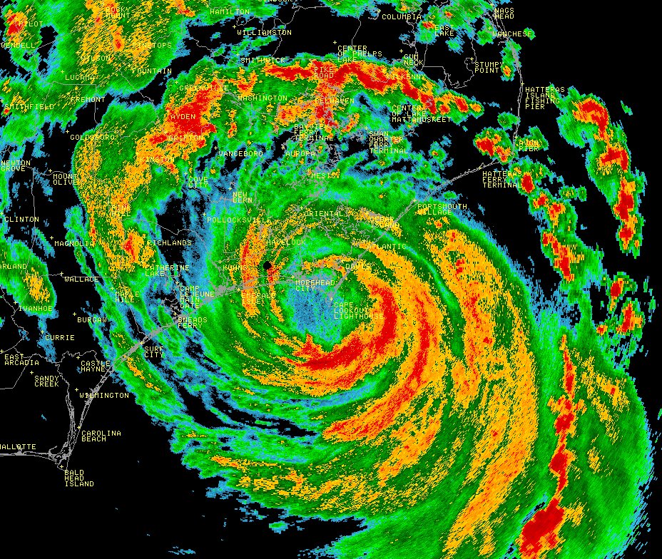
On June 28th, a low pressure system moved off the southeastern U.S. coast and developed into Tropical Storm Arthur on July 1st. Conditions were favorable for tropical cyclone development with low wind shear and warm sea surface temperatures in the region. Arthur slowly drifted northward and strengthened into a hurricane on July 3rd. Arthur reached Category 2 strength with winds of 100 mph and a central minimum pressure of 973 mb before making landfall near Beaufort, North Carolina at 11:15 pm local time that same day. The stormed continued a north-northeastward track as it moved through Pamilico Sound, between the North Carolina mainland and the Outer Banks. Arthur's movement then became more northeastward and moved back out to sea. Outer rain bands from the storm impacted parts of New England, but the storm did not make another direct landfall in the United States. Arthur's largest impacts were heavy rainfall in North Carolina and New England, as well as high storm surge in North Carolina. The storm surge at Oregon Inlet, North Carolina reached 4.5 feet with wave heights over 21 feet. This contributed to massive coastal erosion with water overrunning the only highway along the Outer Banks, which has an elevation of only a few feet above sea level in most locations. Hurricane Arthur was the first hurricane to make landfall in the U.S. since Isaac in August 2012 and the first Category 2 hurricane to make landfall since Ike in 2008. Arthur was also the earliest land falling hurricane in North Carolina and only the fourth hurricane to make landfall in the state during July since reliable records began in 1851. The previous earliest North Carolina hurricane occurred on July 11, 1901.
East Pacific
July 2014 Tropical Cyclone Counts
| Storm Type | July 2014 | July 1981-2010 Average | Record Most for July Period of Record: 1949-2014 |
|---|---|---|---|
| Tropical Strorm (Winds > 39 mph) |
5 | 3.6 | 7 (1985) |
| Hurricane (Winds > 74 mph) |
3 | 1.9 |
4 (1971, 1982, 1990, 1992, 2008) |
| Major Hurricane (Winds > 111 mph) |
1 | 1 |
3 (1978, 1985, 1992) |
July 2014 Individual Tropical Cyclones
| Name | Dates of winds >39 mph |
Maximum Sustained Winds |
Minimum Central Pressure |
Landfall |
|---|---|---|---|---|
| Tropical Storm Fausto | July 7th – 9th | 45 mph | 1004 mb | N/A |
| Tropical Storm Wali | July 17th – 19th | 45 mph | 1001 mb | N/A — Remnant moisture brought flooding rains to Hawaii |
| Hurricane Genevieve | July 25th – still active when report was published | 135 mph | 960 mb | N/A |
| Hurricane Hernan | July 26th – 29th | 75 mph | 992 mb | N/A |
| Hurricane Iselle | July 31th – August 9th | 140 mph | 947 mb | Landfall on August 7th on the Big Island of Hawaii. More information will be provided in August report. |