Atlantic Basin
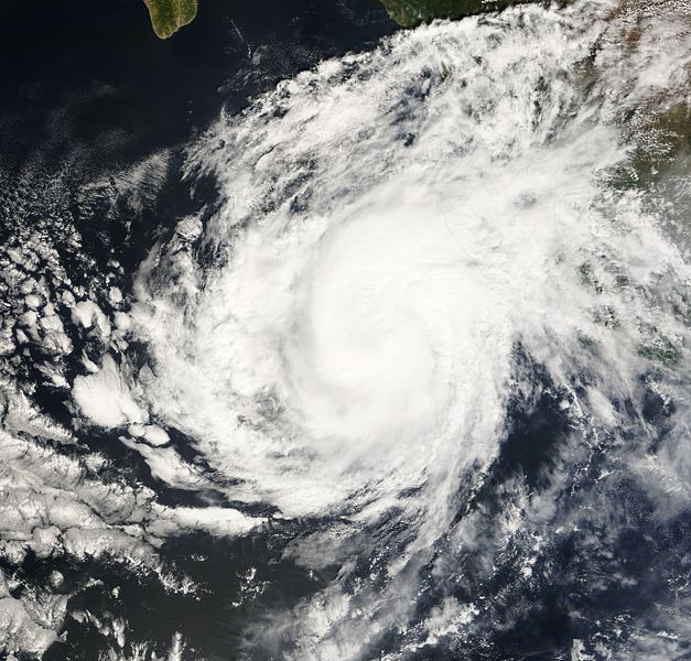
 Hurricane Noel Satellite Image |
 Hurricane Noel Track  Saffir-Simpson Scale Color Legend |
|
Tropical Depression Sixteen organized on the evening of October 27 over the eastern Caribbean. This storm intensified and became Tropical Storm Noel the next afternoon. Tropical Storm Noel made landfall in Haiti on October 29, then slowly passed through the western Caribbean near Cuba for the next few days, bringing torrential rain to the region. Noel, moving into the westerlies, picked up a little speed as it traveled northeastward through the Bahamas. Taking the opportunity of a brief period of decreased shear, Tropical Storm Noel strengthened into a hurricane on November 1. Simultaneously, a mid-level short wave began interacting with Noel, signaling the storm's impending extratropical transition. On November 2, Hurricane Noel began transitioning to a strong extratropical cyclone with sustained winds remaining at the Category 1 hurricane level. This slow transition continued as the storm moved northeast through November 4, when it passed over Labrador. At least 148 people lost their lives to Noel in the Caribbean. The strongest winds in Hurricane Noel were 130 km/hr (70 knots or 80 mph), and its lowest pressure was 980 mb. More information on Hurricane Noel is available from the NOAA National Hurricane Center. |
|
Pacific Basin
 Tropical Storm Kiko Satellite Image |
 Tropical Storm Kiko Track Map Saffir-Simpson Scale Color Legend |
| On October 15, Tropical Depression Fifteen-E formed about 400 miles southwest of Manzanillo, Mexico. It remained relatively stationary and strengthened briefly into Tropical Storm Kiko on the 16th before it weakened from wind shear and was downgraded to a depression. On October 17, the storm intensified back into a tropical storm and began to move east-northeast toward Mexico, then turned northwest on the 19th and moved parallel to the Mexican coast. Kiko continued to strengthen until the 21st, then began to weaken and move westward until it dissipated on October 23. The maximum sustained winds of Tropical Storm Kiko were 110 km/hr (60 knots or 69 mph), and the minimum pressure was 991 mb. More information may be found on NCDC's 2007 Northeast Pacific Tropical Cyclone statistics page, at the NOAA National Hurricane Center. | |