Note: This report catalogs recent tropical cyclones across the North Atlantic and East Pacific and places each basin’s tropical cyclone activity in a climate-scale context. It is not updated in real time. Users seeking the real time status and forecasts of tropical cyclones should visit The National Hurricane Center.
Atlantic Basin
| Tropical Storm Henri developed in the eastern Gulf of Mexico on the 3rd and weakened into a tropical depression before crossing Florida on the 6th. The effects of Henri were minimal, with some localized heavy rain (up to 10 inches in west-central Florida) and gusty winds. Henri dissipated by the 8th. |
|
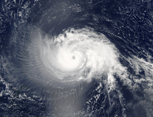
Hurricane Isabel: A tropical wave moving off the shore of Africa developed into Tropical Storm Isabel in the far eastern Atlantic, near the Cape Verde Islands on September 6th, 2003. The next day, as it moved west-northwestward, Isabel developed an eye and reached hurricane strength on the 7th. Conditions were very favorable for Isabel's continued development with warm sea surface temperatures ahead of it, low shear and an impressive outflow pattern from the storm. Rapid intensification occurred over the next several days and Isabel became a category 5 hurricane on the 11th. Isabel weakened slightly on the 13th, but did not weaken considerably until overnight on the 15th/16th when westerly shear began to affect the storm. Isabel decreased in strength to a category 2 storm, and eventually came ashore along North Carolina's Outer Banks on September 18th with sustained winds of approximately 85 knots - a minimal category 2 storm. |
 larger image |
 larger image |
Preliminary estimates of Isabel's precipitation indicate that interior Virginia bore the brunt of the rainfall from Hurricane Isabel. The rainfall from Isabel did not lead to widespread flooding throughout North Carolina and Virginia. However, the unusually high precipitation totals in the months that preceded Hurricane Isabel resulted in very wet soils, and the combination of the wet conditions and strong winds associated with the storm led to downed trees and power outages for millions of people in the mid-Atlantic and Northeast.
Most of the flooding associated with storm occurred at the coastal margin. Hurricane force winds and a
storm surge of as much as 7-10 feet associated with Isabel led to a great deal of destruction at Cape Hatteras, NC, as well as along coastal Virginia and Maryland. Preliminary estimates suggest that 38 people died as a result of Isabel. A comparison between Isabel and 2 other major mid-Atlantic hurricanes of recent years is also available. |
| Hurricane Juan initially appeared to be subtropical in nature, but after forming approximately 295 miles southeast of Bermuda on September 25th, it moved to the north-northwest and was classified as fully tropical. Maximum windspeeds of 105 mph (91 kts) were reached on the 27th as Juan continued to move northward and made landfall in Nova Scotia, near Halifax the following day with somewhat weaker windspeeds. Juan was a category 2 hurricane at landfall - the strongest storm to hit Halifax in its modern history. Eight deaths have been attributed to Juan. |  larger image larger image
|
| Hurricane Kate began as a tropical wave approximately 900 miles west-southwest of the Cape Verde Islands on September 25th. The system became a tropical storm on the 27th. Briefly reaching hurricane strength on the 29th, by the end of the month Kate was located about 600 miles southwest of the Azores. More information on Kate can be found in the October section. |
Pacific Basin
| Tropical Storm Kevin began as a depression on September 3rd about 250 n mi southwest of Cabo San Lucas, Mexico and moved parallel to the Baja California Peninusula becoming a tropical storm on the 4th. Since Kevin formed at a fairly high latitude, its life cycle was short and it quickly weakened back to a depression on the 5th. Hurricane Linda formed from a wave that moved off the coast of Central America on the 6th, becoming a tropical depression on the 14th, and a hurricane on the 15th. Linda weakened back to a depression on the 16th and continued to weaken as it moved southwestward. |
 larger image larger image
|
Hurricane Marty developed as a tropical depression in the eastern Pacific Ocean on the 19th. Marty made landfall along Mexico's Baja Peninsula on the 22nd near San Jose del Cabo with maximum sustained winds near 160 km/hr (85 knots or 100 mph). Marty weakened as it tracked northward across the Gulf of California, spreading heavy rains as far north as Arizona by the 24th. Marty was responsible for 10 deaths, and was the second hurricane in less than a month to affect Baja California (Reuters/AFP). |
 NOAA's National Centers for Environmental Information