Monthly Report Summary Information
The Monthly Report Summary Information is a synopsis of the collection of national and global summaries released each month.
National Summary Information - March 2014
See Full Report
Contiguous U.S. experienced coldest March since 2002
Parts of the Northeast and Midwest experienced near-record cold, while much of the West was warmer than average. Drought intensified in parts of the West and Great Plains.
The average temperature for the contiguous U.S. during March was 40.5°F, 1.0°F below the 20th century average. This was the 43rd coldest March on record and the coldest since 2002. The coldest temperature departures from average occurred across the Great Lakes and Northeast. Vermont had its coldest March on record.
The March national precipitation total was 2.29 inches, 0.22 inch below the 20th century average, and the 41st driest March on record. Parts of the Central Plains and Midwest were much drier than average. In contrast, the Pacific Northwest was much wetter than average, helping to replenish snowpack totals.
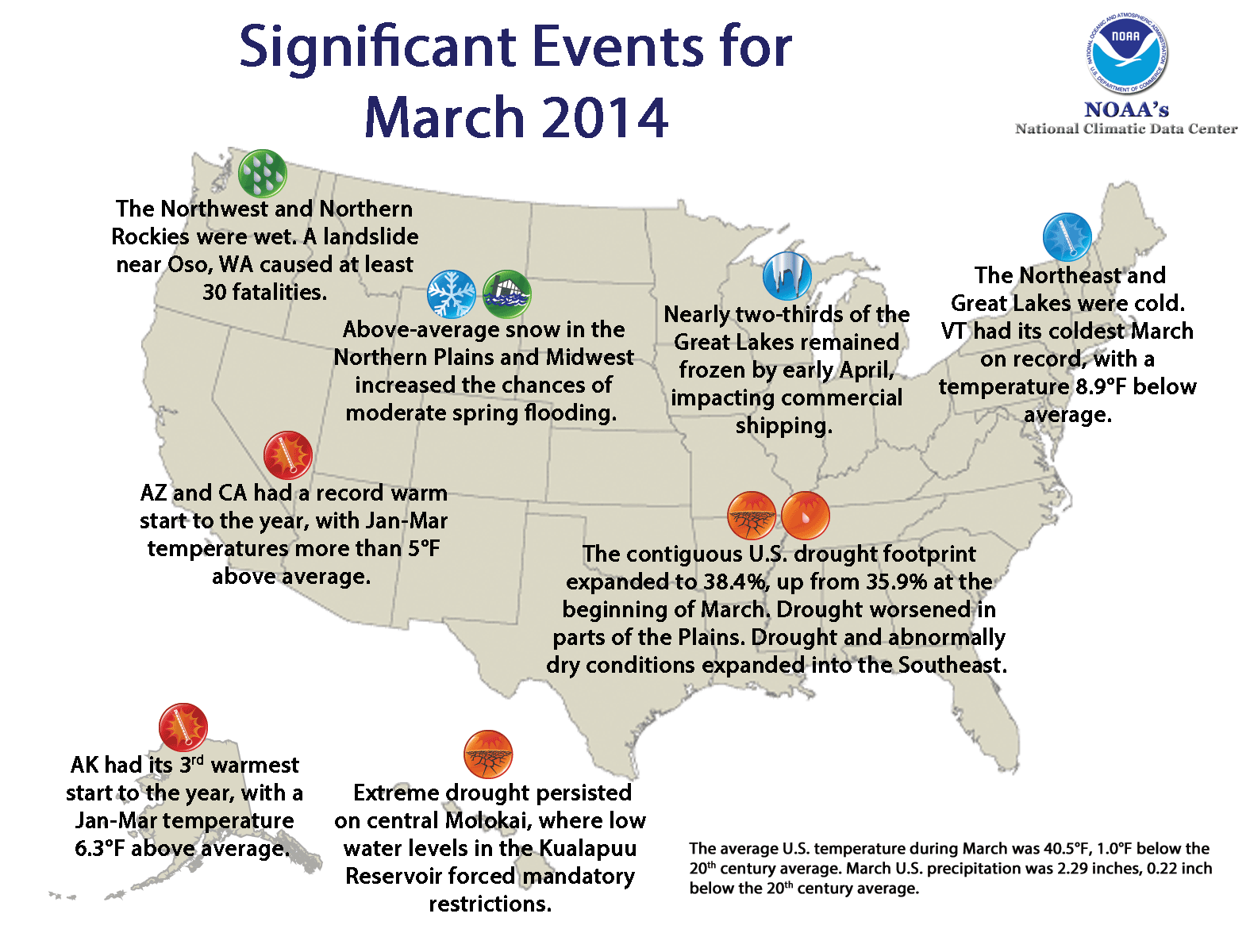
Significant climate events for March 2014. Click image to enlarge, or click here for the National Overview.
Note: The March Monthly Climate Report for the United States has several pages of supplemental information and data regarding some of the exceptional events from the month and year-to-date.
Major climate events NOAA is closely monitoring:
- Drought in the West, Southern Plains, Midwest. Long- and short-term dryness will likely increase wildfire risk and impact water resources and agriculture.
- Spring flooding. According to NOAA's National Weather Service, there is moderate flood potential in the Midwest and Northern Plains due to above-average snow pack and frozen soils. Additionally, flooding is anticipated in northern New England. Late-season ice cover of lakes and rivers will cause an elevated risk of ice jams during the spring melt.
- Frozen Great Lakes. Unseasonably large ice cover in the Great Lakes will limit water loss due to evaporation but will also impact commercial shipping.
U.S. climate highlights: March 2014
- Below-average temperatures dominated the eastern half of the contiguous U.S. during March. The largest departures from average occurred across the Great Lakes and Northeast, where nine states had temperatures that ranked among their 10 coldest on record. The persistent cold resulted in nearly two-thirds of the Great Lakes remaining frozen into early April.
- Vermont had its coldest March on record, with a statewide temperature of 18.3°F, 8.9°F below average. The previous coldest March in Vermont occurred in 1916 when the monthly average temperature was 18.6°F.
- Maine and New Hampshire each had their second coldest March on record, while Michigan and New York had their fifth coldest. Massachusetts and Wisconsin had their eighth coldest March, Connecticut its ninth coldest, and Pennsylvania its 10th coldest.
- Most locations from the Rockies westward had above-average March temperatures. California had its ninth warmest March, with a statewide temperature 4.7°F above average. No state was record warm for March.
- The Northern Rockies and Pacific Northwest were Illinois each had a top 10 dry March.
- On March 22nd, a large landslide impacted the Stillaguamish Valley near the town of Oso, Wash., causing at least 30 fatalities. Washington's Climate Division 3, in which the landslide occurred, observed its wettest March on record. Its 8.67 inches of precipitation during March was more than twice the monthly average.
- According to the April 1 U.S. Drought Monitor report, 38.4 percent of the contiguous U.S. was in drought, up from 35.9 percent at the beginning of March. Beneficial precipitation fell in California during March, but did little to improve drought conditions — 23.5 percent of the state remained in the worst classification of drought ("exceptional"). Drought conditions intensified across parts of the Central and Southern Plains and expanded into parts of the Southeast.
- According to NOAA data analyzed by the Rutgers Global Snow Lab, March snow cover extent across the contiguous U.S. was the 22nd largest in the 48-year period of record at 845,000 square miles, about 104,000 square miles above the 1981-2010 average. Above-average snow cover was observed across the Northern Plains and Rockies, Midwest and Northeast where numerous storms brought heavy snowfall during the month. Below-average snow cover was observed for most of the West and southern Rockies due to season-long snow deficits.

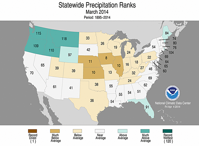
March 2014 Statewide Temperature (top)
and Precipitation (bottom) ranks
U.S. climate highlights: year-to-date (January–March)
- For the first three months of 2014, below-average temperatures were widespread in the eastern U.S. Twelve states, from the Upper Midwest to the Southeast, had three-month temperatures that ranked among the 10 coldest on record. The largest cold departures from average occurred across the Great Lakes region due to persistently below-average daily temperatures. No state had its coldest January-March on record.
- The West was warmer than average during January-March. Nevada, Oregon, and Utah each had one of their 10 warmest on record. Arizona and California were record warm for the period, with temperatures 5.2°F and 5.6°F above average, respectively.
- Collectively during the year-to-date period, the average contiguous U.S. temperature was 34.4°F, 0.8°F below the 20th century average. This marked the 41st coldest January-March on record and the coldest since 1985.
- Alaska had its third warmest January-March on record, behind only those of 1981 and 2001, with an average temperature 6.3°F above the 1971-2000 average. The statewide average precipitation during January-March was 6.1 percent below average, ranking as the 29th driest such period in the 96-year period of record.
- January-March precipitation averaged across the contiguous U.S. was 5.90 inches, 1.06 inches below average, marking the 14th driest such period on record and driest since 2009.
- The Central and Southern Plains and Southwest were much drier than average during the first quarter. Seven states, from Arizona to Missouri, had three-month precipitation totals ranking among the 10 driest on record. The northern Rockies and Northwest were wetter than average, where Montana had its eighth wettest January-March.
- Beneficial rains reduced drought coverage across Hawaii during the first quarter, with 14.4 percent of the islands in moderate to extreme drought at the end of March compared to 49.5 percent of the state at the beginning of the year. Extreme drought (D3) persisted through March on central Molokai, where low water levels in the Kualapuu Reservoir have forced mandatory irrigation restrictions.
- The U.S. Climate Extremes Index (USCEI) for the year-to-date was the 11th highest on record for the period at 145 percent of average. Elements that contributed to the above average USCEI included the spatial extent of cold maximum and minimum temperatures, warm maximum temperatures, one-day precipitation totals, and the spatial extent of drought. The USCEI is an index that tracks extremes (falling in the upper or lower 10 percent of the record) in temperature, precipitation and drought across the contiguous U.S.
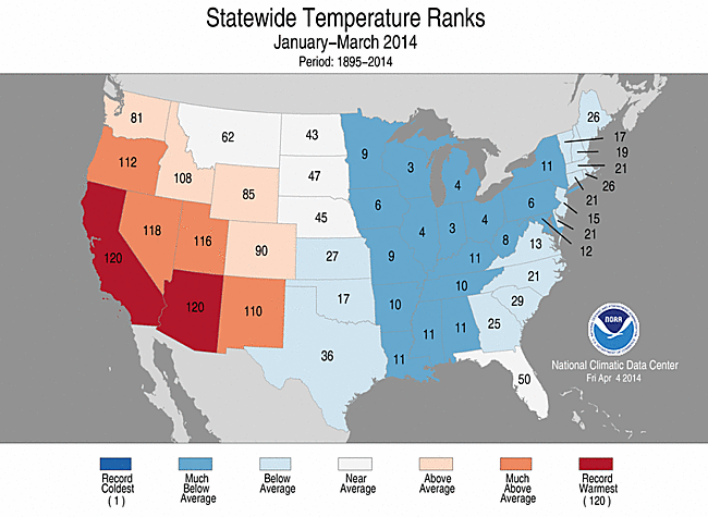
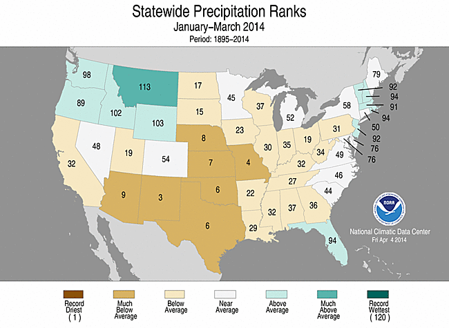 January–March 2014 Statewide Temperature (top)
 and Precipitation (bottom) ranks
U.S. climate highlights: cold season (October 2013–March 2014)
- The average contiguous U.S. temperature during the cold season was 38.2°F, 0.4°F below the 20th century average. This was the 32nd coldest October-March on record and the coldest since 2000/01.
- Similar to the past several months, below-average temperatures were widespread across the eastern U.S. Ten states, from Minnesota to Louisiana, had six-month temperatures that ranked among the 10 coldest on record. It was warmer than average in the Southwest, where Arizona and California had one of their 10 warmest October-March periods. No state was record cold or record warm.
- The average contiguous U.S. precipitation during the cold season was 12.37 inches, 1.33 inches below the 20th century average, the 22nd driest such period on record and the driest since 2000/01.
- Below-average precipitation was observed across much of the West, southern Rockies, and Central and Southern Plains. October-March represents the first six months of the water year in the West. California had its third driest October-March on record, with a statewide precipitation total of 9.35 inches, about 50 percent below average.
- The Northern Plains and Rockies were wetter than average during the cold season, with much of the precipitation falling in the form of snow, contributing to the moderate spring flood risk across the region. South Dakota had its fifth wettest cold season, while Wyoming had its sixth wettest and North Dakota its 10th wettest.
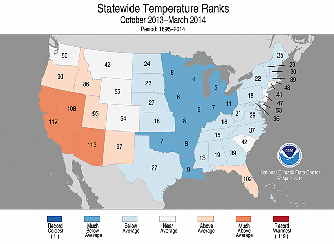
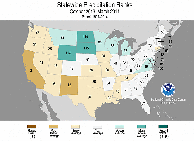
October 2013–March 2014 Statewide Temperature (top)
and Precipitation (bottom) ranks