Monthly Report Summary Information
The Monthly Report Summary Information is a synopsis of the collection of national and global summaries released each month.
National Summary Information - November 2014
See Full Report
For extended analysis of regional temperature and precipitation patterns, as well as extreme events, please see our full report that will be released on December 10th.
November was 16th coldest on record for the contiguous US
Eastern U.S. was cold, while the Southwest was warm. The contiguous US snow cover extent was record large. Alaska had fifth warmest November on record.
During November, the average contiguous U.S. temperature was 39.3°F, which is 2.4°F below the 20th century average. This ranked as the 16th coldest November in the 1895-2014 record, and was the coldest November since 2000. The average contiguous U.S. precipitation was 2.07 inches, 0.16 inch below average, and ranked near the median value in the 120-year period of record.
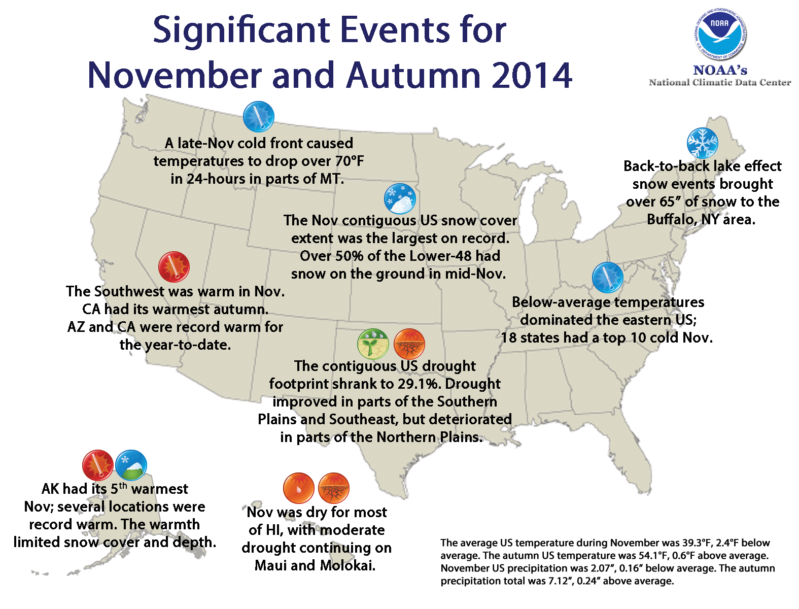
Significant climate events for November 2014.
U.S. climate highlights: November 2014
- Locations from the Rockies to the East Coast were cooler than average, where 18 states across the Midwest, Ohio Valley, and Southeast had a top 10 cool November. No state was record cold, but Alabama and Mississippi each had their second coldest November. The Southwest was warmer than average, where California had its ninth warmest November on record. No state was record warm during November.
- Alaska had its fifth warmest November in the 1918-2014 record, with a temperature 7.7°F above the 1971-2000 average. Several locations across the state had their warmest November on record, including King Salmon and Homer. In fact, this marked the fifth month of 2014 that Homer has been record warm. The warm temperatures limited snow cover and depth across Alaska. Ski resorts near Anchorage were not able to open for the Thanksgiving holiday for the first time in over a decade.
- The Northern Rockies and parts of the Southern Plains, Southeast, and Great Lakes were wetter than average. The Southwest, Central Plains, Northeast, parts of the Midwest, and most of Hawaii were drier than average. No state had a top 10 wet or dry November.
- According to the Rutgers Global Snow Lab, the November snow cover extent for the contiguous U.S. was 400,000 square miles above the 1981-2010 average and the largest November snow cover extent in the 49-year satellite record. This bested the previous record large November snow cover extent that occurred in 2000. Several snow events occurred during November, including back-to-back lake effect snow episodes that brought over 65 inches of snow to the Buffalo, NY region and a Thanksgiving Nor'easter that snarled holiday travel along the East Coast.
- According to the December 2nd U.S. Drought Monitor report, 29.1 percent of the contiguous U.S. was in drought, down from 29.6 percent at the end of last month. Drought conditions improved across parts of the Southern Plains and Southeast, but worsened across parts of the Northern Plains.

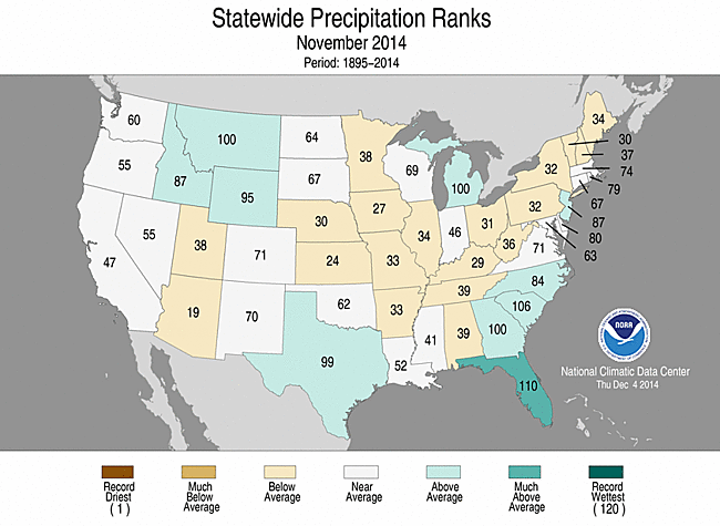
November 2014 Statewide Temperature (top)
and Precipitation (bottom) ranks
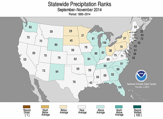
U.S. climate highlights: autumn (September–November) 2014
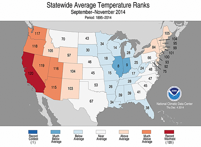
Autumn 2014 Statewide Temperature (top)
and Precipitation (bottom) ranks
- During autumn, the average contiguous U.S. temperature was 54.1°F, 0.6°F above the 20th century average. This ranked near the median value in the 120-year period of record. The cold November was roughly balanced by the warm September and October. Above-average temperatures were observed in the West and Northeast. In the West, six states had a top 10 warm autumn, including California, which was record warm. Below-average temperatures were observed across the Midwest and through the Mississippi River Valley. Illinois and Indiana each had a top 10 cool autumn. No state had its coldest autumn on record.
- The total autumn precipitation for the contiguous U.S. was 7.12 inches, 0.24 inch above the 20th century average. This also ranked near the median value in the 120-year period of record. Above-average precipitation was observed in parts of the Northwest, Southwest, central Great Lakes, and the Southeast. Below-average precipitation was observed in the Northern Plains and the eastern Great Lakes. Much of the country recorded near-average precipitation for the season. No state had a top 10 wet or dry autumn.
- The U.S. Climate Extremes Index (USCEI) for autumn was 25 percent below average, ranking as the 33rd lowest autumn USCEI on record. The component that examines extremes in warm nighttime temperatures was above average and ranked as the 11th highest value on record. On the regional scale, the West had its sixth highest CEI on record, driven largely by warm daytime and nighttime temperatures and the spatial extent of drought. The USCEI is an index that tracks extremes (falling in the upper or lower 10 percent of the record) in temperature, precipitation, drought, and land-falling tropical cyclones across the contiguous U.S.
U.S. climate highlights: year-to-date (January–November) 2014
- During January-November, the average contiguous U.S. temperature was 54.0°F, 0.2°F above the 20th century average. This ranked near the median value in the 120-year period of record, but was the coldest year-to-date since 1997.
- Continuing the pattern observed during much of 2014, the western U.S. was warmer than average, while the East was cooler than average. In the West, eight states had one of their 10 warmest January-November periods on record, including Arizona and California which were record warm. The Arizona statewide average temperature was 2.9°F above average, while the California statewide average temperature was 4.1°F above average. In the East, 12 states had one of their 10 coldest year-to-dates on record, mostly from the Midwest through the Mississippi River Valley. No state had a record cold January-November.
- Alaska had its second warmest year-to-date on record, with a temperature 3.6°F above the 1971-2000 average. The warmest January-November occurred in 1926.
- The January-November total precipitation for the contiguous U.S. was 28.22 inches, 0.63 inch above the 20th century average. This ranked near the median value in the 120-year period of record.
- Above-average precipitation was observed across the northern tier of the country. Michigan and Wisconsin each had a top 10 wet January-November period. Below-average precipitation was observed in the Southwest, Southern Plains, and parts of the Ohio Valley and New England. No state had a top 10 dry year-to-date.
- The USCEI for January-November was 45 percent above average, and ranked as the 11th highest value on record. Extremes in both warm and cold maximum and minimum temperatures, 1-day precipitation totals, and days with precipitation contributed to the elevated 11-month USCEI value. The Upper Midwest, Ohio Valley, and West each had CEI values for the January-November period that ranked among the five highest on record.


Year-to-Date 2014 Statewide Temperature (top)
and Precipitation (bottom) ranks
For extended analysis of regional temperature and precipitation patterns, as well as extreme events, please see our full report that will be released on December 10th.