Monthly Report Summary Information
The Monthly Report Summary Information is a synopsis of the collection of national and global summaries released each month.
National Summary Information - October 2014
See Full Report
October was fourth warmest on record for the contiguous US
Western and most of Northeastern U.S. were much warmer than average. Drought persisted in the West, while parts of the Midwest were much wetter than normal.
The average temperature for the contiguous U.S. during October was 57.1°F, 3.0°F above the 20th century average. This was the fourth warmest October on record for the Lower 48. The October precipitation total for the contiguous U.S. was 2.33 inches, 0.17 inch above average, ranking near the median value in the 120-year period of record.
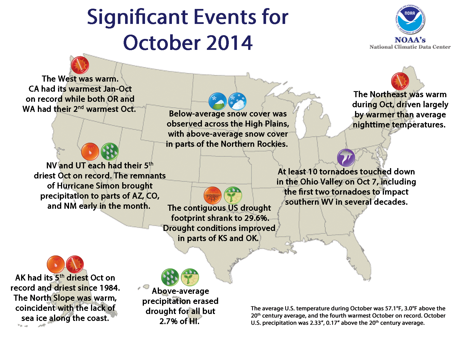
Significant climate events for October 2014.
Click image to enlarge, or click here for the National Overview.
Note: The October Monthly Climate Report for the United States has several pages of supplemental information and data regarding some of the exceptional events from the month, season, and year-to-date.
Major climate events NOAA is closely monitoring:
- Persisting drought in parts of the West: The drought across the West, Southwest and Southern Plains showed little improvement in October. The next few months are critical for Western snowpack, a vital component of Western water resources. More information is available from the U.S. Drought Monitor.
- El Niño still probable later this year: According to NOAA's Climate Prediction Center, there is about a 3-in-5 chance of at least a weak El Niño developing during winter and lasting into spring 2015. El Niño conditions could impact temperature and precipitation patterns across the U.S. More information is available from NOAA's Climate Prediction Center.
U.S. climate highlights: October 2014
- Locations from the Rockies westward and large parts of the Northeast were much warmer than average during October, with record warmth along much of the Pacific coast. Sixteen states, including every state west of the Rockies, had one of their 10 warmest Octobers on record. Much of the Great Plains and South were also warmer than average. Near-normal temperatures prevailed in the Midwest. This was the first month since July 2013 with no state observing a statewide temperature in the below-average category.
- The near-average October precipitation total for the contiguous U.S. masked some regional extremes. Nevada and Utah each had their fifth driest October on record, within a larger area of below-average precipitation in much of the Northern Plains and Northern Rockies. Most of the Mississippi River Valley saw above-average precipitation; Kentucky, Missouri and Tennessee each observed one of their 10 wettest Octobers on record.
- According to the October 28 U.S. Drought Monitor, 29.6 percent of the contiguous U.S. was in drought, down one percentage point since the end of September. Drought conditions improved modestly in parts of eastern Kansas and Oklahoma. Abnormally dry conditions improved somewhat in the Mid-Atlantic. The entire state of California remained in drought, as did the vast majority of adjacent states Arizona, Nevada and Oregon. More than half of California remains in Exceptional Drought, the most severe category.
- Alaska was warmer and much drier than average during October. The state had its fifth driest October on record with a precipitation value 35.1 percent below the 1971-2000 average. The North Slope was warmer than average, continuing a recent pattern of warm Octobers coincident with an era of below-average sea ice extent near the region. According to the National Weather Service Alaska Region, October 2014 marked the 13th consecutive October with an average monthly temperature warmer than 20°F at Barrow, Alaska. Before 2002, about one in five Octobers was warmer than this mark.
- In Hawaii, rainfall was substantially above normal, erasing drought for all but 2.7 percent of the state. On October 17-18, Hurricane Ana passed about 150 miles southwest of the Hawaiian Islands, bringing 5.40 inches of rain to the U.S. Climate Reference Network station on Mauna Loa.
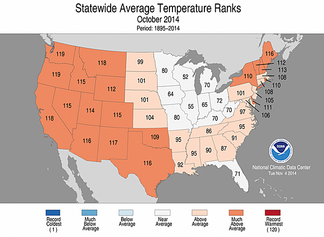

October 2014 Statewide Temperature (top)
and Precipitation (bottom) ranks
U.S. climate highlights: year-to-date (January–October) 2014
- The January-October contiguous U.S. temperature was 55.4°F, 0.5°F above the 20th century average. The West continued to be much warmer than average, where eight states had a top 10 warm year-to-date. California was record warm for January-October, with a temperature 4.2°F above its 20th century average. It is virtually certain that 2014 will be California's warmest year on record. States in the Mississippi River Valley continued to be much below average. No state was record cold.
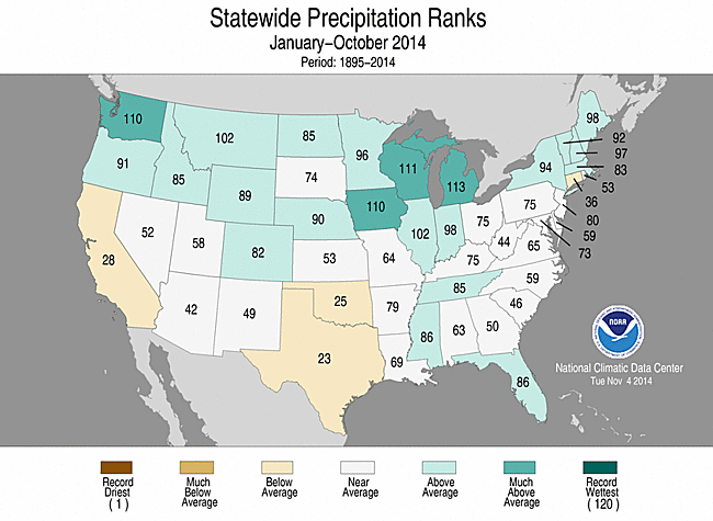
- The year-to-date national precipitation total was 26.04 inches, 0.68 inch above the 20th century average. Above-average precipitation dominated most of the northern tier of states, where Wisconsin and Michigan each had one of their top 10 wet year-to-date periods. Below-average precipitation was observed in parts of the West and Southern Plains.
- The U.S. Climate Extremes Index (USCEI) for the January-October period was the sixth highest in the 105-year period of record at roughly one-and-a-half times the long-term average. The elevated year-to-date USCEI value was partially due to extremes in both warm daily maximum and minimum temperatures. The component that examines extremes in one-day precipitation totals was the fourth highest for the year-to-date period. The USCEI is an index that tracks extremes (falling in the upper or lower 10 percent of the record) in temperature, precipitation, drought and land-falling tropical cyclones across the contiguous U.S.
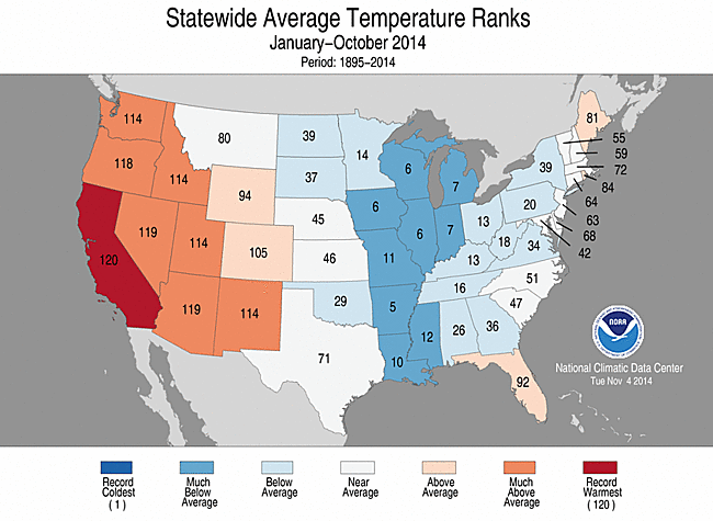
 January–October 2014 Statewide Temperature (top)
 and Precipitation (bottom) ranks
For additional analysis of regional temperature and precipitation patterns, as well as extreme events, please see our full report.