Monthly Report Summary Information
The Monthly Report Summary Information is a synopsis of the collection of national and global summaries released each month.
National Summary Information - July 2013
See Full Report
Contiguous U.S. wetter and warmer-than-average during July
July was fifth wettest, 30th warmest on record; flooding impacted the Southeast, drought continued in the West, Alaska had fifth warmest July
The average temperature for the contiguous U.S. during July was 74.3°F, 0.8°F above the 20thcentury average. The West and Northeast were fifth warmest July, with Anchorage setting a record of 14 consecutive days above 70°F.
The nationally-averaged precipitation total for July was 3.47 inches, 0.71 inch above the 20thcentury average. July brought both wet and dry precipitation extremes to the nation. The Northwest and Upper Mississippi River Valley were above-average precipitation.
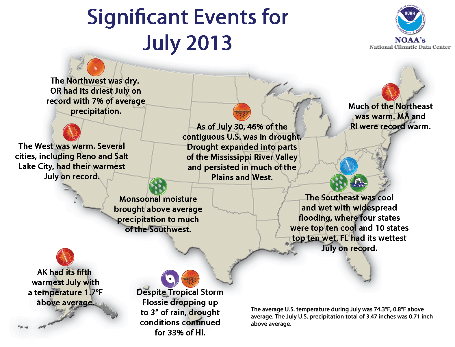
Significant climate events for July 2013.
Click image to enlarge, or click here for the National Overview.
Note: The July Monthly Climate Report for the United States has several pages of supplemental information and data regarding some of the weather/climate events from the month and year-to-date.
U.S. climate highlights: July
-
The western U.S. was Rhode Island, which had a record warm July.
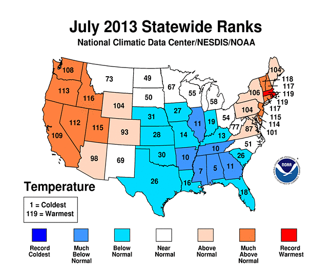
 July 2013 Statewide Temperature (top) and Precipitation (bottom) ranks
- Locations from the Central Plains into the Southeast were Tennessee — had July temperatures that were among the 10 coolest on record.
- California both had July precipitation totals ranking among the 10 wettest. During this time of year in parts of the Southwest, even light precipitation can result in above-average monthly totals but have minimal impacts on alleviating drought conditions.
- In the East, 13 states had one of their 10 wettest Julys on record, with the Florida had its wettest July on record, with 12.38 inches of rainfall, 4.91 inches above average. The above-average precipitation in the Southeast resulted in widespread flooding and significant damage to crops.
- The Northwest was particularly Iowa had its tenth driest July.
- According to the July 30 U.S. Drought Monitor report, 45.6 percent of the contiguous U.S experienced drought conditions, up slightly from the beginning of July. Drought remained entrenched throughout much of the West and in parts of the Central and Southern Plains, and drought expanded into parts of the Lower Mississippi River Valley and Midwest. Over 20 percent of Alaska was in drought at the end of July, with severe drought developing in central parts of the state.
U.S. climate highlights: year-to-date (January-July)
- The year-to-date contiguous U.S. temperature of 51.8°F was 0.5°F above the 20thcentury average and tied with 1952 as the 42nd warmest January–July on record. Below-average temperatures stretched from the Northern Plains to the Southeast.
- The year-to-date contiguous U.S. precipitation total of 19.14 inches was 1.54 inches above average and tied with 1997 as the 22nd wettest January-July on record. However, rainfall was not evenly distributed across the country. wet precipitation extremes were observed in the East.
- California, Idaho, Nevada, and Oregon each had a top 10 dry year-to-date period. California's precipitation total of 4.58 inches was record low for the seven-month period at 9.82 inches below average, and 1.69 inches less than the previous record dry January-July of 1898.
- Michigan was record wet with 24.35 inches of precipitation, 6.92 inches above average, and 2.30 inches above the previous record wet January-July of 1950.
- The components of the U.S. Climate Extremes Index (USCEI) that examine extremes in the spatial extent of drought, as well as 1-day precipitation totals and days with rainfall were much above average for the year-to-date. When combined with the other components of the index, the USCEI, as a whole, was only slightly above average. The USCEI is an index that tracks the highest and lowest 10 percent of extremes in temperature, precipitation, tropical cyclones, and drought across the contiguous United States.