Monthly Report Summary Information
The Monthly Report Summary Information is a synopsis of the collection of national and global summaries released each month.
National Summary Information - March 2013
See Full Report
March cool and dry for the contiguous United States
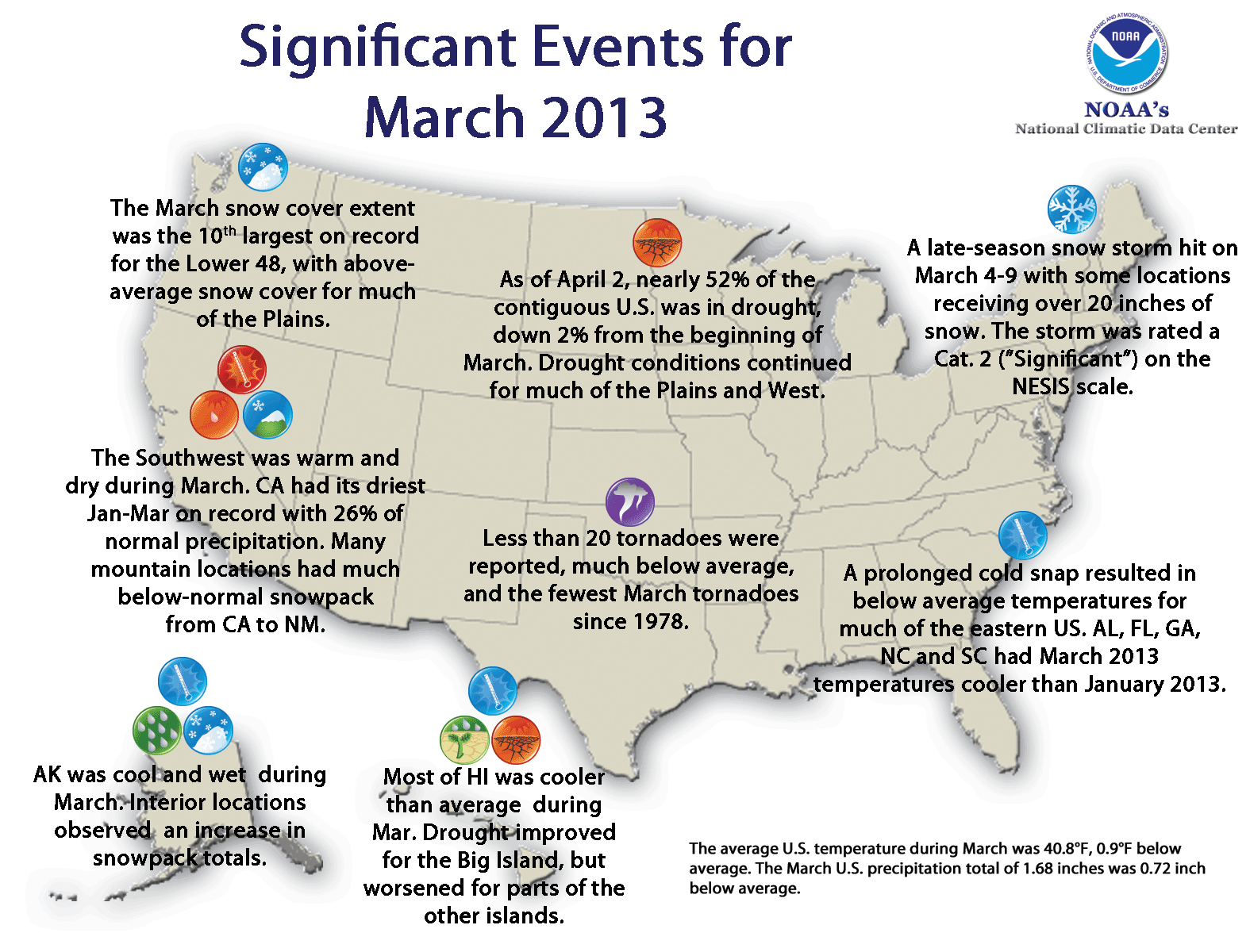
U.S. experiences coolest March since 2002. Drought conditions continue in the Great Plains and West. March snow cover extent 10th largest on record.
The average temperature for the contiguous U.S. during March was 40.8°F, 0.9°F below the 20th century average and the 43rd coolest March on record. Colder temperatures dominated east of the Rockies and warm conditions prevailed in the West. For the first three months of 2013, the national temperature was 0.5°F above average.
The March nationally-averaged precipitation total of 1.68 inches was 0.72 inch below the long-term average. This marked the fifth driest March on record for the nation, and the driest since 1966. Drought improved in the Southeast and Midwest, while drought continued to impact much of the Great Plains and West.
Significant climate events for March 2013.
Click image to enlarge, or click here for the National Overview.
Note: The March Monthly Climate Report for the United States has several pages of supplemental information and data regarding some of the weather/climate events from the month.
U.S. climate highlights: March
-
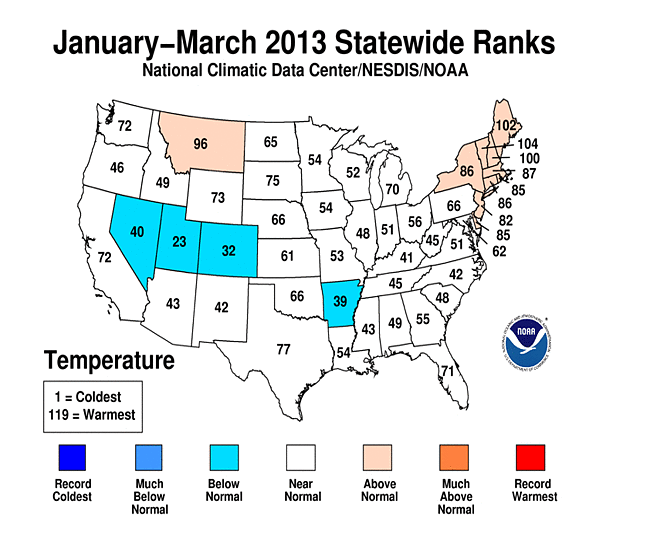
Eleven states in the Ohio Valley, along the Gulf Coast, and in the Southeast had March temperatures that were among their ten coolest. Alabama, Florida, Georgia, North Carolina, and South Carolina had March 2013 temperatures that were cooler than January 2013.

 March 2013 Statewide Temperature (top) and Precipitation (bottom) ranks
- Temperatures were above average for parts of the New Mexico.
- A Minnesota was the only state with above-average March precipitation.
- Several storms brought late-season snowfall to the eastern two-thirds of the country. According to data from the Rutgers Global Snow Lab, the March snow cover extent for the contiguous U.S. was the 10th largest in the 47-year period of record. However, snowpack, an important water resource in the West, was below-normal in the Sierra Nevada Mountains as well as the Central and Southern Rockies.
- According to the April 2 U.S. Drought Monitor report, 51.9 percent of the contiguous U.S. was experiencing moderate-to-exceptional drought, smaller than the 54.2 percent at the end of February, but significantly higher than 36.8 percent at the beginning of April last year. Drought conditions improved in parts of the Southeast, as well as the eastern edge of the core drought areas in the Central and Southern Plains due to increased precipitation over the past three to six months. Drought remained entrenched across the rest of the Great Plains and interior western states.
U.S. climate highlights: Year-to-Date (January — March)
- Mid-South were cooler than average.
- The nationally-averaged precipitation total for the year-to-date period was 6.04 inches, 0.60 inch below average.
- The Wyoming also had one of their ten driest year-to-date periods.
- Michigan had its tenth wettest January-March with a precipitation total 136 percent of average.
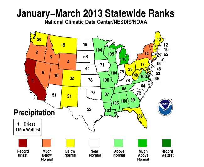 Year-to-Date Statewide Temperature (top) and Precipitation (bottom) ranks
U.S. climate highlights: Cold Season (October 2012 — March 2013)
- The U.S. cold season was 1.1°F warmer than average, with a nationally-averaged temperature of 40.3°F. A large area of the country had Vermont experienced its eighth warmest cold season, with an average temperature 3.6°F above average.
- The cold season was drier than average for the nation as a whole, with a precipitation total of 12.16 inches, 0.95 inch below average. Above-average precipitation was observed in the Midwest, the central Gulf Coast, and Mid-Atlantic.
- The U.S. Climate Extremes Index (USCEI), an index that tracks the highest and lowest 10 percent of extremes in temperature, precipitation and drought across the contiguous U.S., was below average during the cold season. However, the component that examines the spatial extent of drought was three and a half times the normal value for the six month period and the third largest October-March value in the 103-year period of record. Only the cold seasons of 1953/54 and 1934/35 had larger drought components of the USCEI.