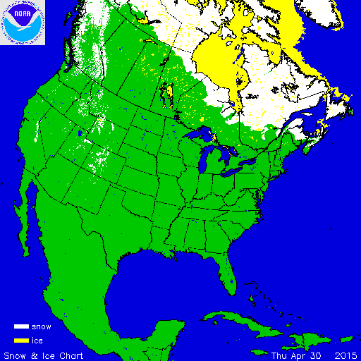
During April, much of the contiguous U.S. was warmer than average, which limited snow cover. A much warmer than average end of 2014 and start of 2015 was associated with a severely limited mountain snowpack for much of the West, particularly in California and the Pacific Northwest. According to NOAA's National Snow Analysis, at the beginning of April, 8.3 percent of the contiguous U.S had snow on the ground — the highest elevations in the West, parts of the central Great Lakes, and much of the Northeast. By the end of April, the contiguous U.S. snow footprint shrank to 2.5 percent with snow only on the ground in the highest elevations of the West and far northern New England. During the course of the month, there were no major snow events in the contiguous United States, with much of the snow on the ground remaining from snow events during the preceding months.

According to NOAA data analyzed by the Rutgers Global Snow Lab, the April snow cover extent for the contiguous U.S. was 161,000 square miles, 121,000 square miles below the 1981-2010 average. This was the 10th smallest April snow cover extent for the contiguous U.S. and the smallest since 2012. Above-average snow cover was observed across the Northeast and parts of the Northern Rockies. Below-average snow cover was widespread in the West and the Central and Northern Plains stretching into the Midwest. Across Alaska, the April snow cover extent was 533,000 square miles, 16,000 square miles below the 1981-2010 average and the seventh smallest April snow cover extent for the state. Most Aprils have complete snow coverage for Alaska. Below average snow cover was observed across western regions of the state.

Winter and spring mountain snowpack provide a crucial water source across much of the western United States. The total annual water budget for agriculture and human use in the mountainous West is highly dependent on the amount of snow melt that will occur in spring and is proportional to the amount of snow on the ground. The annual snow pack typically peaks in early April. As of May 1st, most locations from the Great Basin to the West Coast had much below-average snow pack. In the Cascade and Sierra Nevada Mountains, snow pack totals were less than 25 percent of normal and record low for several locations. For parts of California, this marks the fourth consecutive spring with much below average snow pack, causing significant concerns for water resources going into the warm and dry season. Snow pack was also less than 25 percent of normal for much of the Great Basin and southern Rockies. Near-average snow pack was observed in the Central and Northern Rockies. In Alaska, snow pack totals less than 25 percent of average were observed across southern regions of the state, while interior locations had snow pack closer to average.