During January, most locations across the western half of the country were warmer than average — the farther west the larger the departures from average. Below-average temperatures were observed in the Northeast and parts of the South. Most locations were drier than average, particularly the West Coast and parts of the Central Rockies and Plains. The warm and dry conditions in the West limited snowfall across the region, contributing to worsening long-term drought conditions.
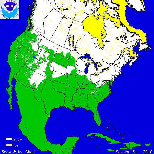
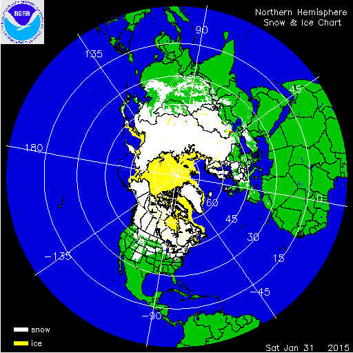
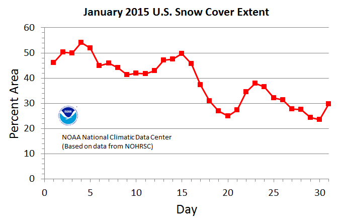
According to NOAA's National Snow Analysis, at the beginning of January, 46.2 percent of the contiguous U.S. had snow on the ground — the Cascades, the Central and Northern Rockies and Plains, parts of the Upper Midwest, and northern New England. Monthly snow cover peaked on the 4th with 54.1 percent of the Lower 48 having snow on the ground. Warm temperatures the third week of January across much of the country caused the snow footprint to drop to 25.0 percent, but two storms at the end of the month caused the snow cover footprint to jump to 29.8 percent of the contiguous U.S. by January 31st. At month's end, the northern Cascades, most of the Rockies, the Midwest, and the Northeast were snow covered.

According to NOAA data analyzed by the Rutgers Global Snow Lab, the January snow cover extent for the contiguous U.S. was 1.29 million square miles, 75,000 square miles below the 1981-2010 average. This was the 18th smallest January snow cover extent in the 49-year period of record for the contiguous United States. Above-average snow cover was observed across the High Plains, the Great Lakes, and parts of the Northeast. Below-average snow cover was observed across much of the West, the Central Plains, Ohio Valley, and into parts of the Mid-Atlantic.

Winter and spring mountain snowpack provide a crucial water source across much of the western United States. The total annual water budget for agriculture and human use in the mountainous West is highly dependent on the amount of snow melt that will occur in spring and is proportional to the amount of snow on the ground. Above-average precipitation across the West during December boosted snowpack at the highest elevations, but above-average temperatures caused most of the precipitation in lower elevations to fall as rain. January was very warm and dry in the West causing much of the December snow to melt, severely limiting the snowpack. According to the USDA, as of February 1st, mountain snowpack from the Sierra Nevada Mountains in California, northward through the Cascades of Oregon and Washington was less than 25 percent of the 1981-2010 median. Most locations in the Northern and Central Rockies had snowpack totals closer to average, while the southern Rockies of Arizona had much-below average snowpack. In Alaska, below-average snowpack was observed from southern coastal regions into the panhandle. In central Alaska, snowpack totals were closer to average.
Significant Events

Jan 25-28 Snowfall Totals
On January 25th through 28th, a strong storm system, called a Nor'easter, brought blizzard conditions and coastal flooding to New England. Snowfall exceeding 4 inches was widespread from the Mid-Atlantic to Maine with the heaviest snow totals, exceeding 30 inches in some locations, across Connecticut, Massachusetts, New Hampshire and Maine. Several New England cities had storm snowfall totals that were among the 10 largest on record; see table below. The storm system tracked farther east than originally forecasted with Philadelphia and New York missing the worst of the storm. Wind gusts of 78 mph were observed on Nantucket Island in Massachusetts, with a storm surge of 4.5 feet causing flooding on the island. In Boston Harbor, a storm surge of 4.8 feet was reported which caused damage to low lying buildings and roads. Hundreds of flights were cancelled due to the storm with most major roadways in the region shut down for at least a day. The storm was rated a Category 3 "Major" winter storm for the Northeast on the Regional Snowfall Index (RSI), and a Category 2 "Significant" on the Northeast Snowfall Impact Scale (NESIS) which examines a larger geographical area. This event was the first of a series of winter storms to impact the region into February, which broke numerous multi-day snowfall records. An analysis of those storms will appear in the February report released in early March.
| Location | January 25-28 Snowfall Totals | Storm Snowfall Rank |
|---|---|---|
| Boston, MA | 24.6 inches | 6th highest |
| Blue Hill Observatory, MA | 30.8 inches | 2nd highest |
| Portland, ME | 23.8 inches | 4th highest |
| Providence, RI | 19.1 inches | 4th highest |
| Worcester, MA | 34.5 inches | Record highest |