Overview:
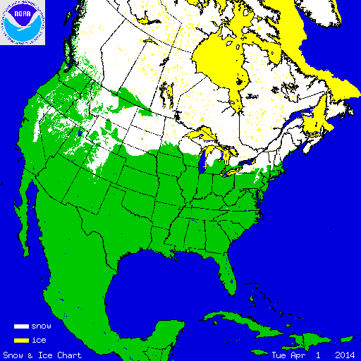
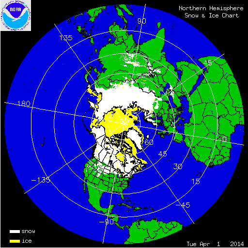
During April, the annual snow retreat across the contiguous U.S. occurred in earnest with the return of warmer, seasonal temperatures. Two snow storms impacted the Northern Plains and Upper Midwest in early and mid-April, causing temporary increases in the national snow footprint. According to NOAA's National Snow Analysis, at the beginning of April, 26.7 percent of the contiguous U.S. was snow covered — the high terrain of the West, the Northern Plains, Upper Midwest, Great Lakes, and parts of the northern interior Northeast. The monthly snow cover peaked on the 4th, when 28.3 percent of the Lower 48 was snow covered. By the end of April, the snow footprint shrank to 8.5 percent of the contiguous U.S., with snow observed across parts of the Sierra Nevada Mountains and Cascades, much of the central and northern Rockies, and parts of the Northern Plains, Upper Midwest, and far northern New England.

According to NOAA data analyzed by the Rutgers Global Snow Lab, the April snow cover extent for the contiguous U.S. was 256,000 square miles, 26,000 square miles below the 1981-2010 average, and the 23rd smallest (26th largest) April snow cover extent on record. Above-average snow cover was observed across parts of the central Rockies, the Upper Midwest, and parts of northern New England. Below-average snow cover was observed across much of the West, Northern Plains, and part of the Northeast. In Alaska, a warm winter combined with a warm and dry early spring, particularly in western parts of the state, resulted in below-average snow cover extent. The April snow cover extent for the state was 533,000 square miles, which was 16,000 square miles below average, and the sixth smallest April snow cover extent on record.

Winter and spring mountain snowpack provide a crucial water source across much of the western United States. The total annual water budget for agriculture and human use in the mountainous West is highly dependent on the amount of snow melt that will occur in spring and is proportional to the amount of snow on the ground. As of May 1st, below-average snowpack was observed across the Sierra Nevada Mountains, the central and southern Cascades, parts of the Great Basin, and in the Southern Rockies. Locations in California, New Mexico, Oregon, Utah, and southern Colorado had less than 25 percent of normal snowpack. Above-average snowpack was observed in the northern and central Rockies, where locations in Montana, Idaho, Wyoming, and northern Colorado had snowpack totals greater than 180 percent of normal. Near-normal snowpack was observed in the northern Cascades. In Alaska, much of the state had below-average snowpack, with locations in southern and interior regions having less than 25 percent of normal snowpack.
Summary of Notable Snow Events:

On April 3th and 4th, a low pressure system developed across the Central Plains, moved through the Midwest, and into the Northeast. Along the northern periphery of the storm, heavy snow accumulated across the central Rockies, and parts of the Northern Plains, Upper Midwest, and Great Lakes region. Over a foot of snow was observed in Michigan, Wisconsin, and Minnesota, with over 17.0 inches in Superior, Wisconsin. The snow hit the Twin Cities area during the evening rush hour commute, causing significant travel disruptions on highways. The Minneapolis-St. Paul International Airport received 6.5 inches of snow during the event, but other parts of the metropolitan area received over a foot of snow, marking one of the ten largest April snowfalls observed in the region.

On April 16th and 17th, another late-season snow storm impacted the Upper Midwest. Snowfall totals well over one foot were observed in Michigan, Minnesota, and Wisconsin. Twenty inches of snow was observed in North Branch, Minnesota. In Duluth, Minnesota, over six inches of snow fell, contributing to the 125.3 inches of snow that fell during the entire season, the fifth snowiest season on record for the city. Only the snow seasons of 1995/96, 1949/50, 2012/13, and 1996/97 were snowier in Duluth. During the event, intense snowfall rates of one to two inches per hour were observed, causing significant travel delays and numerous automobile accidents that resulted in at least one fatality. The rain/snow line set up just north of the Minneapolis-St. Paul metropolitan area, with the city just missing the heaviest of the snow.