Overview:
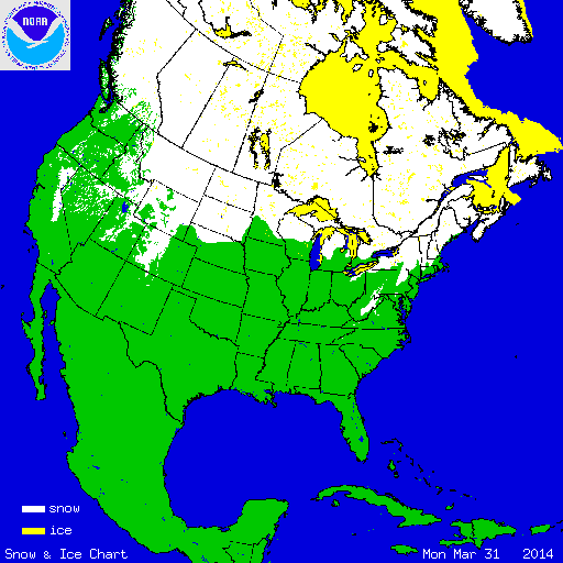
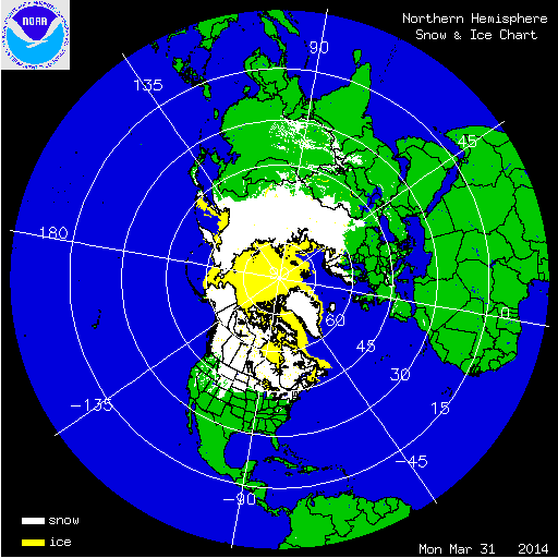
During March, numerous winter storms impacted the country, continuing an active pattern that dominated much of the preceding winter. According to NOAA's National Snow Analysis, at the beginning of March, 36.9 percent of the contiguous U.S. had snow on the ground — the Sierra Nevada Mountains, the Cascades, the Central and Northern Rockies, much of the Central and Northern Plains, the Midwest, and the Northeast. The snow cover peaked on March 3rd, when 57.3 percent of the Lower-48 was snow covered. By the end of March, 22.9 percent of the contiguous U.S. had snow on the ground — the Sierra Nevada Mountains, the Cascades, the Northern and Central Rockies, the Upper Midwest, and much of the interior Northeast.

According to NOAA data analyzed by the Rutgers Global Snow Lab, the March snow cover extent for the contiguous U.S. was 845,000 square miles, which was 104,000 square miles above the 1981-2010 average. This ranked as the 22nd smallest (27th largest) March snow cover extent on record. Above-average snow cover was observed across the Northern Rockies and Plains, the Midwest, the Mid-Atlantic, and the Northeast. Below average snow cover was observed across the Southern Rockies, the Great Basin, and much of the Far West.

Winter and spring mountain snowpack provide a crucial water source across much of the western United States. The total annual water budget for agriculture and human use in the mountainous West is highly dependent on the amount of snow melt that will occur in spring and is proportional to the amount of snow on the ground. During March, a persistent onshore flow and storm track helped increase snowpack totals across the Pacific Northwest where below-average snowpack was observed early in the winter season. Those storm systems also increased snowpack totals across the Northern and Central Rockies. On April 1st, snowpack totals greater than 180 percent of normal were observed in Idaho, Montana, Wyoming, and Colorado. Near-average snowpack totals were observed across the Pacific Northwest and Utah. Despite several storms impacting Oregon, California, and the Southern Rockies, season-long snowfall deficits were too high to be overcome by the late-season snowfall. Snowpack totals less than 50 percent of normal were widespread in the southern Cascades, the Sierra Nevada Mountains, and Southern Rockies, with some locations having less than 25 percent of normal snowpack. In Alaska, below-average snowpack was observed in southern regions of the state, with near-average snowpack reported for most interior locations.
Summary of Notable Snow Events:
In early March, a storm that impacted the western U.S. in late February moved into the central and eastern United States, bringing wintry precipitation and strong winds. Behind the storm system, cold temperatures filtered into areas east of the Rocky Mountains. Snowfall greater than 6 inches accumulated across a large area, from the Great Plains and Midwest, into the Southeast and Northeast. Heavy freezing rain and sleet were observed in the Lower Mississippi River Valley. The storm caused numerous governors to declare states of emergency, with hundreds of thousands of households losing power, numerous interstates closing, and thousands of flights being cancelled. Federal government offices were closed in Washington, D.C., where six inches of snow accumulated. State government offices closed in the state capitals that were impacted. There were at least 12 fatalities blamed on the storm.

On March 12th and 13th, a low pressure system moving through the Midwest and into the Northeast dropped heavy snow from Illinois to Maine. Six inches of snow was widespread across the Midwest. The storm intensified as it moved off the Northeast coast, bringing over one foot of snow to the Northeast. Sharon, Vermont received 26 inches of snow during the event. In western New York, blizzard conditions were observed in Buffalo, marking the first time in 130 years of record keeping that blizzard conditions were observed twice in the same winter season. The biggest impacts from the storm were to travel conditions with interstates being forced to close and thousands of flights being canceled.
Another round of heavy snow impacted the Midwest and Northeast on March 16th and 17th. Snow accumulations greater than six inches were observed across with the Midwest, with snow totals approaching one foot in the Mid-Atlantic and Northeast. At Reagan National Airport, in Washington, D.C., seven inches of snow fell over the two days, with 3.9 inches of snow on March 17th marking the snowiest St. Patrick's Day on record for that location. The storm also marked the 10th largest March snow accumulation for Washington, D.C., and the third largest snowfall this late in the season. Reagan National Airport had to completely shut down for several hours, as crews were unable to keep runways clear. The heaviest snow fell across northern Virginia, where Haywood observed 13.5 inches.

On the last day of March, a strong low pressure system brought blizzard conditions to a large portion of the Northern Plains and Upper Midwest, with blizzard warnings issues for much of the Dakotas and parts of Minnesota. Snowfall totals greater than 10 inches were widespread across Nebraska, the Dakotas, Montana, and Minnesota. Twenty inches of snow was observed in Grafton, North Dakota. The storm also brought strong winds, approaching hurricane strength. Wind gusts over 60 mph were reported in parts of Nebraska and South Dakota. The combination of strong winds and heavy snow resulted in visibilities as low as 10 feet. Whiteout conditions prompted the closure of Interstates 29 and 94. Ahead of the snow, thunderstorms were observed. In western Minnesota, a weak tornado touched down early in the day on the 31st, with blizzard conditions reported in the same location a few hours later.