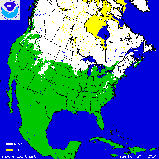
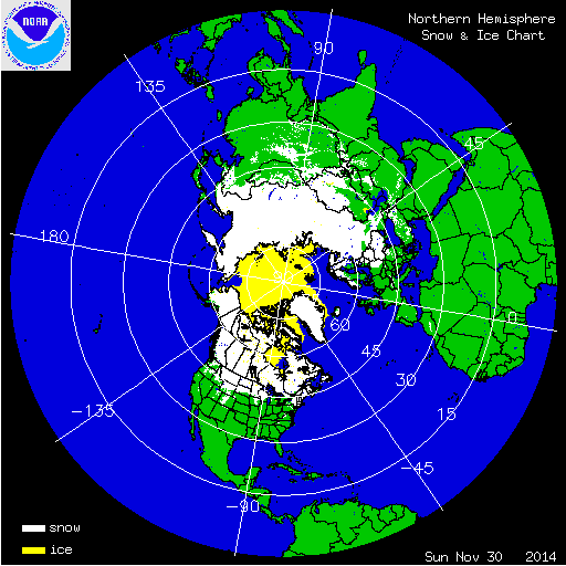
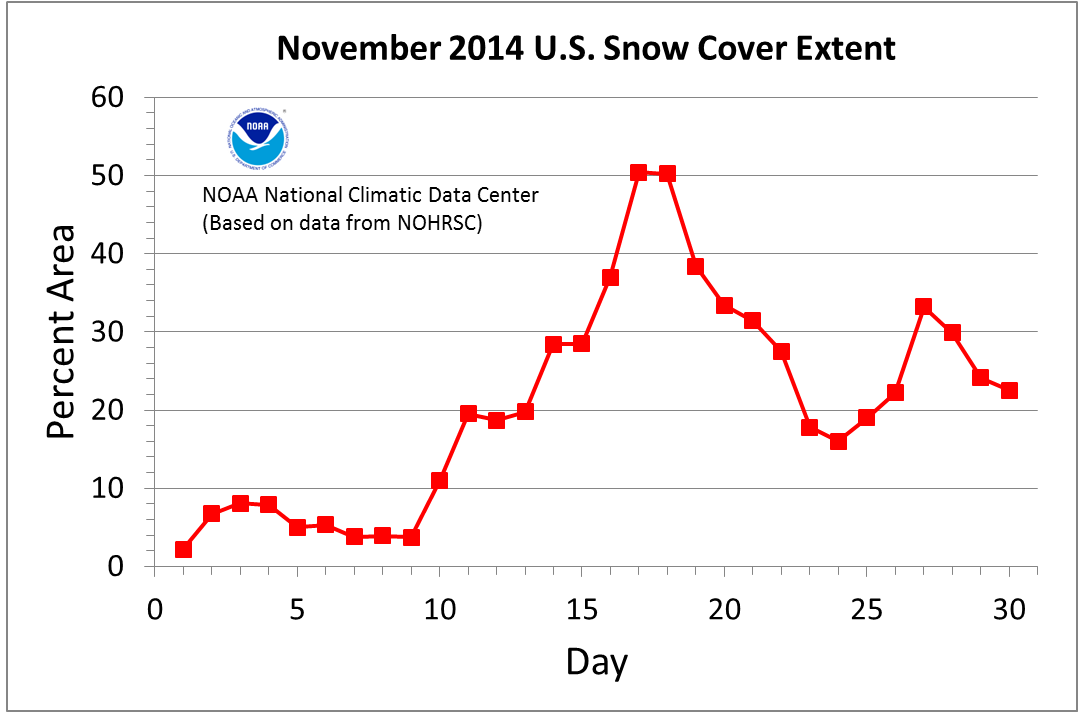
During November, the eastern two-thirds of the contiguous U.S. (CONUS) was cooler than average. Several cold-air outbreaks impacted the country, with the associated cold fronts bringing widespread snowfall. The cold temperatures allowed snow to remain on the ground for several days, boosting the monthly snow cover extent for the month, despite the snow lacking much depth for most locations. According to NOAA's National Snow Analysis, at the beginning of November, 2.2 percent of the CONUS had snow on the ground — the northern Cascades and parts of the Upper Midwest and Ohio Valley. Monthly snow cover peaked on the 17th, when 50.4 percent of the CONUS had snow on the ground. A warm-up near the end of the month resulted in the snow cover extent shrinking to 22.8 percent of the country, with snow on the ground across the Cascades, parts of the Great Basin, the Northern Rockies and Plains, Upper Midwest, and the interior Northeast.

According to data from the Rutgers Global Snow Lab, the monthly snow cover extent across the CONUS during November was 876,000 square miles. This was 400,000 square miles above the 1981-2010 average and the largest November snow cover extent in the 49-year satellite record. This bested the previous record large November snow cover extent that occurred in 2000 by 34,000 square miles, which is approximately the size of Indiana. Above-average November snow cover was observed across the Northeast, Ohio Valley, Midwest, Great Plains, and the Northern and Central Rockies. Below-average snow cover was observed in parts of the Mid-Atlantic and the Southwest. In Alaska, the monthly snow cover extent was 505,000 square miles, 26,000 square miles below the 1981-2010 average and the fifth smallest November snow cover extent on record. Below-average snow cover was observed across western and southern portions of the state where record and near-record warm temperatures were osbserved during November, with near-average snow cover observed elsewhere.

From October 31st through November 3rd, a low pressure system moved through the Ohio River Valley, into the Southeast, and then parallel up the East Coast into the Northeast. Strong winds and heavy snow was reported from the Southeast to New England. Snowfall accumulations exceeding 20 inches were reported in the higher elevations of the Southern Appalachians of North Carolina and Tennessee. The storm brought the first snowfall of the season to many high elevations locations of Virginia, West Virginia, Kentucky, South Carolina, and Georgia. The Columbia, South Carolina airport received a trace of snowfall on November 1th, marking the earliest date of observed snowfall for the city. The previous earliest date for observed snowfall in Columbia was November 9th, 1913. Some locations on the outskirts of the town received up to 4 inches of snow. A trace of snow was observed as far south as the South Carolina coast. In Asheville, North Carolina, 3.2 inches of snow was observed at the airport, the fourth highest 1-day snowfall total for November. As the storm moved up the coast, it strengthened, bringing heavy snow to parts of New England. Interior locations of Maine received over a foot of snow.

Between November 17th and 21st, two lake effect snow events impacted the Buffalo, New York region. The first event occurred on the 17th through 19th. As a low pressure system moved through the region, southwesterly winds set up across Lake Erie. Air temperatures were several degrees below freezing, but the lake temperature was around 48°F, which was slightly below average for this time of year. The contrast in temperatures between the strong winds and water caused a lake effect snow band to set up just south of downtown Buffalo. The snow band was approximately 20 miles in width and produced snowfall rates greater than six inches per hour. Winds in excess of 40 miles per hour were reported, causing blizzard conditions where snow was observed. The band of snow was narrow enough that locations just miles apart had significantly different snow accumulations. Lancaster, New York received 63 inches of snow, while the Buffalo airport just four miles away received 6.2 inches. Several locations south and east of Buffalo received over 60 inches of snow in 24 hours, potentially breaking the New York State record for 24-hour snowfall total (pending review by the State Climate Extremes Committee). Just a few days later, a second lake effect snow event set up in the same location. This event didn't drop as much snowfall in singular locations because the wind direction varied slightly during the event causing the heavy snowfall to fall over a larger spatial area. Wales Center, New York received 49 inches of snow from this specific event. When the snow totals from the two events are combined, several locations to the south and east of Buffalo had snow totals approaching 80 inches. A few days after the event, the temperature in Buffalo soared, reaching 65°F on the 24th. The warm temperatures were accompanied by rain, causing a significant amount of the snow to rapidly melt, resulting in widespread flooding in the region. During the entire event, there were 13 reported fatalities, with hundreds of major roof collapses and structural failures. The strong winds and heavy snow also caused numerous power outages in the impacted areas.

26-28 Nov. Northeast Snowfall
On November 26th and 27th, a Nor'easter moved along the U.S. East Coast bringing strong winds and heavy precipitation. Snowfall totals exceeded one foot across interior areas of the Mid-Atlantic and the Northeast. The highest snowfall accumulations were measured in high elevation areas of West Virginia. Wind gusts over 50 mph were observed in coastal areas of New England as the storm moved through. The largest impact from the event was related to the high number of people travelling for the Thanksgiving Holiday on the 27th. The day before Thanksgiving is typically one of the busiest travel days of the year for Americans. Hundreds of flights across the densely populated northeast corridor were cancelled or delayed due to the weather, with ripple effects felt across the nation. The storm was rated a Category One (Notable) on NOAA's Northeast Snowfall Impact Scale.