Please Note: This will be the last monthly U.S. Snow and Ice Report until October 2012.
Overview:
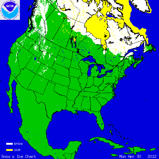
During April, warmer-than-average temperatures dominated much of the contiguous U.S., limiting snowfall during the month. Large areas of the nation, particularly the Northeast and the mountain West, were drier than average in April. At the beginning of the month, 8.2 percent of the Lower-48 was snow covered — the highest elevations in the West, and parts of the Great Lakes and Northeast. On April 30th, the percent area of snow coverage shrank to 4.1 percent with snow on the ground across the highest elevations in the West and parts of the Northeast. A late-season coastal storm dropped several inches of snow across the Northeast near the end of the month, causing some impacts across the region.

According to data from the Rutgers Global Snow Lab, the monthly snow cover extent across the contiguous U.S. was approximately 114,300 square miles, which is 162,100 square miles below the 1981-2012 average. This was the third smallest April snow cover extent on record for the contiguous United States, slightly larger than the snow cover extents of April 1968 and 2004. Most regions of the country experienced below-average snow coverage, with the exception of the central Appalachians, where a late-season storm brought heavy snow accumulations. According to data from the U.S. Department of Agriculture, snowpack totals across the West were mixed at the end of April. The Pacific Northwest had snowpack levels which were much above normal, with near-normal snowpack stretching into the Northern Rockies. Parts of the Cascades and the Olympic Range in Washington had snow pack totals greater than 180 percent of normal. The rest of the mountainous West had much-below-normal snowpack totals, stretching from the Sierra Nevadas, across the Great Basin, and into the Central and Southern Rockies. Snow pack totals less than 25 percent of normal were widespread. The amount of snowpack at this time of year is important in determining the water supply for the region during the upcoming summer period.
Summary of Notable Snow Events:

A late-season storm dropped over a foot of snow from West Virginia to Upstate New York, along the higher elevations of central and northern Appalachian Mountains, on April 23rd and 24th. To the east, in the lower elevations, heavy rain fell across the large cities of the Northeast. This type of coastal storm, called a Nor’easter, was only the second of the season to impact the eastern seaboard, with the other being very early in the season in October. The snow storm was also on the heels of the warmest March on record for many locations across the region, where most trees already had begun to leaf. The snow falling on trees with leaves caused additional headaches by bringing down limbs and cutting power to at least 75,000 residents. The storm also resulted in at least 48 daily snowfall records. Although the storm did have some negative impacts, it provided drought-relieving precipitation for many locations in the Northeast.