National Overview:

- Climate Highlights — January
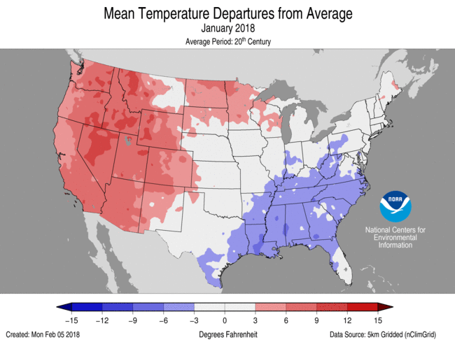 January Average Temperature Departures |
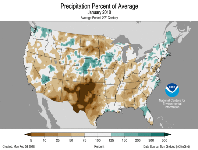 January Percent of Average Precipitation |
Temperature
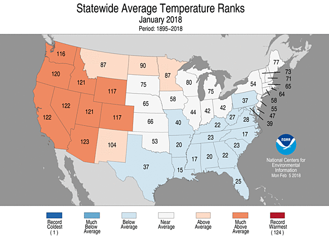
January 2018 Statewide Temperature Ranks
- During January, the average contiguous U.S. temperature was 32.2°F, 2.1°F above the 20th century average. This ranked among the warmest third of the 124-year period of record.
- Most locations from the Rockies to the West Coast were warmer than average, where nine states had monthly temperatures that ranked among the 10 warmest on record. While no state was record warm during January, more than 2,000 daily warm temperature records were broken or tied across the region.
- Below-average temperatures stretched from the Southern Plains to the East Coast. Several significant cold waves impacted the eastern half of the nation during January with more than 4,000 daily cold temperature records broken or tied across the East. No state had a record cold monthly temperature.
- The Alaska January temperature was 6.8°F, 4.6°F above the long-term average. This ranked in the warmest third of the 94-year period of record for the state. The first half of January was mild across Alaska with a cold end to the month. According to the National Weather Service, on January 14, the temperature at a NOAA tide gauge at Ketchikan reached 67°F, the highest January daily temperature ever measured in Alaska. The previous record was 62°F in January 2014.
- The contiguous U.S. average maximum (daytime) temperature during January was 43.2°F, 2.7°F above the 20th century average, ranking in the warmest third of the record. Much-above-average maximum temperatures were observed from the Rockies to West Coast where 10 states had a top 10 warm maximum temperature. Below-average maximum temperatures were observed in the Southeast.
- The contiguous U.S. average minimum (nighttime) temperature during January was 21.2°F, 1.5°F above the 20th century average, ranking near the median value. Above-average conditions were observed for much of the West and parts of the Upper Midwest and New England. Seven states in the West had a top 10 warm January minimum temperature. Below-average minimum temperatures stretched from the Southern Plains to Midwest, Mid-Atlantic and Southeast. North Carolina had its ninth coldest January minimum temperature.
- During January there were 4,654 record warm daily high (2,140) and low (2,514) temperature records, which was about 20 percent less than the 5,941 record cold daily high (3,190) and low (2,751) temperature records.
- Based on NOAA's Residential Energy Demand Temperature Index (REDTI), the contiguous U.S. temperature-related energy demand during January was slightly below average and tied 1960 as the 59th lowest value in the 124-year period of record.
Precipitation
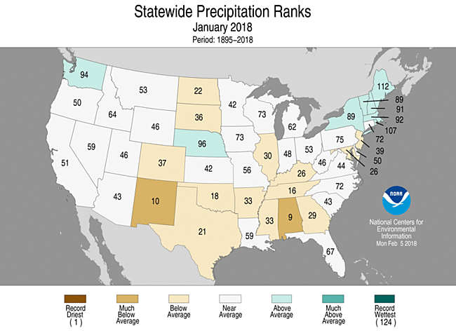
January 2018 Precipitation Ranks
- The January precipitation total was 1.81 inches, 0.50 inch below the 20th century average. This tied the 21st driest January on record.
- During January, below-average precipitation was observed across large areas of the country, including parts of the Southwest, Southern Plains, Northern Plains, Midwest, Southeast and Mid-Atlantic. Alabama had its ninth driest January and New Mexico tied its 10th driest. Above-average precipitation was observed across parts of the Northwest, Central Plains and Northeast.
- During January, numerous snow storms impacted the eastern U.S., bringing snow and ice to locations across the South that hadn’t experienced snow in many years. On January 4, the Savannah, Georgia, airport received 1.2 inches of snow, the most since 1989. Conversely, snow generally missed large parts of the West. Mountain locations in the Southern Cascades, Southern Rockies and Sierra Nevada Mountains had snowpack totals that were less than 25 percent of average. The lack of snow in the West could result in below-average spring runoff causing water resource concerns. Tourism in the region was also impacted.
- According to NOAA data analyzed by Rutgers Global Snow Lab, the January snow cover extent was 35,900 square miles below the 1981-2010 average and ranked near the median value in the 52-year period of record. Above-average snow cover was observed in the Central and Northern Plains, Midwest, Northeast, and parts of the Mid-Atlantic. Below-average snow cover was observed for much of the West and Southern Plains.
- According to the January 30 Drought Monitor report, 38.4 percent of the contiguous U.S. was in drought, up from 27.7 percent at the beginning of the month. This was the largest drought footprint since May 2014. Drought conditions expanded and intensified in parts of the West, Southern Plains and Southeast. Some drought improvement was observed in the Northern High Plains, Central Plains, Lower Mississippi Valley and coastal Southeast.
- The NOAA National Weather Service issued a drought statement for Guam, Northern Mariana Islands and the Marshall Islands as drought intensified and spread during January 2018. With 0.94 inch of rain, the weather station at Guam observed the driest January in the 1957-2018 record.
**A comparison of the national temperature departure from average as calculated by NCDC's operational dataset (nClimDiv), the U.S. Historical Climatology Network (USHCN), and the U.S. Climate Reference Network (USCRN) is available on our National Temperature Index page.**
Regional Highlights:
These regional summaries were provided by the six Regional Climate Centers and reflect conditions in their respective regions. These six regions differ spatially from the nine climatic regions of the National Centers for Environmental Information.
- Northeast Region: (Information provided by the Northeast Regional Climate Center)
- The first month of 2018 wrapped up on the cold side of normal. The Northeast's January average temperature of 21.7 degrees F (-5.7 degrees C) was 1.5 degrees F (0.8 degrees C) below normal. Nine of the twelve states were colder than normal, with average temperature departures ranging from 3.7 degrees F (2.1 degrees C) below normal in West Virginia to 0.3 degrees F (0.2 degrees C) below normal in Massachusetts. Departures for the warmer-than-normal states ranged from 0.2 degrees F (0.1 degrees C) above normal in Vermont to 1.0 degrees F (0.6 degrees C) above normal in Maine.
- The Northeast was wetter-than-normal in January. The region received 3.50 inches (88.9 mm) of precipitation, which was 113 percent of normal. Five states were drier than normal, while seven states were wetter than normal. Precipitation for all states ranged from 74 percent of normal in Maryland to 156 percent of normal in Maine, making it the state's 13th wettest January on record. In addition, Rhode Island had its 18th wettest January.
- According to the U.S. Drought Monitor released on January 4, parts of Maryland and eastern Pennsylvania were in a moderate drought (totaling 5 percent of the Northeast) and 19 percent of the region was abnormally dry. During the month, moderate drought and abnormal dryness lingered or slightly expanded. By month's end, conditions worsened in parts of central and southern Maryland, leading to the introduction of severe drought. Below-normal streamflow and groundwater levels were reported in some areas, especially those experiencing severe drought. The U.S. Drought Monitor released on February 1 showed 5 percent of the Northeast was in a severe or moderate drought and 21 percent of the region was abnormally dry.
- From January 3 to 5, a nor'easter dropped up to 24 inches (61 cm) of snow on the Northeast, mainly coastal areas from southern Maryland to northern Maine. The storm produced snowfall rates of up to 3 inches (8 cm) per hour, and thundersnow was reported in several locations. Thirteen major climate sites set daily snowfall records, with a few sites ranking their daily snow total among their top five greatest for January. Strong winds of up to 76 mph (34 m/s) produced blizzard conditions in parts of New England and southeastern New York. More than 5,000 flights were cancelled nationwide, mostly in the Northeast. Kennedy and LaGuardia airports suspended operations, with Kennedy Airport being closed for around 20 hours. There were also power outages in the region. In addition, parts of coastal New England experienced high water levels and significant flooding. Boston, Massachusetts, had its highest tide on record (since 1921) and Portland, Maine, had its third highest tide on record (since 1912). Storm reports indicated that some areas were inundated by up to five feet (1.5 m) of water, with numerous impassable roads and flooded basements. Later in the month, the region experienced alternating periods of colder-than-normal temperatures and seasonable or warmer-than-normal temperatures. Rainfall, snowmelt, and ice jams contributed to flooding on several waterways, with reports of closed roads, flooded homes and buildings, and some evacuations and water rescues.
- For more information, please go to the Northeast Regional Climate Center Home Page.
- Midwest Region: (Information provided by the Midwest Regional Climate Center)
- Conditions in January were mostly on the dry side in the Midwest, particularly in west central Minnesota where less than a quarter inch (6 mm) of precipitation fell and Kentucky where deficits up to 2.00 inches (51 mm) below normal were noted along the Tennessee border. A few locations had monthly totals that failed to reach 50 percent of normal and west central Minnesota had less than 25 percent of normal for the month. The areas with above-normal precipitation were mostly from Iowa to Upper Michigan. A couple hundred daily record high values were recorded in January with most occurring from the 11th to the 13th or the 22nd to the 23rd. Every Midwest state had at least eight stations with record precipitation days.
- The Midwest saw big temperature swings in January. The month began with frigid temperatures across the region. Hundreds of record low daily temperatures were set across the region, particularly in the first three days of the month. Average temperatures for the first seven days of January were well below normal across the region with most areas at least 15 degrees F (8 C) below normal and a bulls eye on the Illinois-Indiana border had temperatures more than 25 degrees F (14 C) below normal. Northwest Minnesota was only 5 to 10 degrees F (3 to 6 C) below normal for the first week. The middle two weeks of the month saw rapid swings to warm and cold followed by very warm conditions in the last 10 days of the month. Temperatures across the Midwest were 5 to 10 degrees F (3 to 6 C) above normal for this 10-day period. There were 1350 record high daily temperatures and 747 record low daily temperatures during the month with most of the record lows occurring in the first three days of the month and the records highs occurring later, many from the 10th to the 12th or from the 20th to the 27th. On average, temperatures were closer to normal for January with near-normal temperatures in Minnesota, Wisconsin, and Michigan and slightly below-normal temperatures (1 to 4 degrees F or 1 to 2 C below normal) for the remaining parts of the region.
- The generally dry conditions led to a slight expansion of drought in the Midwest in January. The area of extreme drought in south central Missouri remained steady but areas of moderate drought expanded during the month. The percentage of the region in drought increased from about 9 percent to 12 percent from the 2nd to the 30th. At the end of the month, about 60 percent of Missouri was in drought while areas in southwest Illinois, southeast Iowa, and northern Minnesota were also in drought.
- Severe thunderstorms made an appearance in the Midwest on just two days. On the 21st, two tornadoes were reported along with a handful of severe wind reports in Missouri. Damage was primarily trees and limbs downed. The following day saw severe weather further east, large hail was reported in Illinois and Kentucky and severe winds were reported in Indiana, Ohio, and Kentucky. The couple dozen wind reports included several noting tree damage and a few noting damage to barns in Ohio.
- Snowfall was below normal in January for most areas of the region. A swath from northwest Iowa to northwest Wisconsin had above normal totals mostly due to the storm on the 22nd and 23rd. Storm totals peaked from 12 to 17 inches (30 to 43 cm). The swath of above-normal snow along the Ohio River and into central Ohio was from an event on the 13th which dropped 2 to 6 inches (5 to 15 cm) in this area. Lake-effect snows downwind of the Great Lakes was a mixed bag with higher values off the southern tip of Lake Michigan and in parts of Upper Michigan while there were lower values in parts of Upper Michigan and across most of Lower Michigan, particularly in northern Lower Michigan.
- For further details on the weather and climate events in the Midwest, see the weekly and monthly reports at the Midwest Climate Watch page.
- Southeast Region: (Information provided by the Southeast Regional Climate Center)
- Temperatures were well below average across much of the Southeast region (excluding Puerto Rico and the U.S. Virgin Islands) during January. Monthly mean temperatures were at least 3 degrees F (1.7 degrees C) below average for approximately 60 percent of the 194 long-term (i.e., period of record equaling or exceeding 50 years) stations across the region. However, only 22 long-term stations observed monthly mean temperatures that were ranked within their five coldest values on record, including Sylacauga 4 NE, AL (1955-2018; third coldest), Yadkinville 6 E, NC (1958-2018; third coldest), Ninety Nine Islands, SC (1961-2018; tied for third coldest), Covington Filtration Plant, VA (1961-2018; fourth coldest), Camilla 3 SE, GA (1939-2018; fourth coldest), and Jasper, FL (1953-2018; fourth coldest). The persistence of daytime and nighttime coldness was exceptional for many locations during the month. Several long-term stations in the Carolinas and Virginia observed or tied their highest or second highest count of January days with a maximum temperature of 32 degrees F (0 degrees C) or less, including Greensboro, NC (1903-2018; 8 days), Williamsburg 2 N, VA (1952-2018; 7 days), New Bern, NC (1949-2018; 6 days), Elizabeth City, NC (1934-2018; 5 days), and Florence, SC (1948-2018; 4 days). Other long-term stations observed or tied their second or third highest count of January days with a minimum temperature at or below 20 degrees F (-6.7 degrees C), such as Roanoke, VA (1913-2018; 16 days), Charlotte, NC (1879-2018; 14 days), Augusta, GA (1875-2018; 9 days), Wilmington, NC (1875-2018; 7 days), and Charleston, SC (1939-2018; 5 days). The coldest weather of the month occurred from the 1st through the 7th, as strong polar high pressure systems ushered in frigid air that originated near or north of the Arctic Circle (i.e., latitude of 66.6 degrees N). Daily minimum temperatures fell below 25 degrees F (-3.9 degrees C) across much of the region north of Florida, with broad portions of North Carolina and Virginia reaching 10 to less than -10 degrees F (-12.2 to less than -23.3 degrees C). Greensboro, NC observed a maximum temperature at or below 32 degrees F on all 7 days, which is its second longest streak for any month on record. Ending on the morning of the 8th, Raleigh-Durham International Airport, NC (1944-2018) recorded its longest streak of 201 consecutive hours with an air temperature of 32 degrees F or lower, which surpasses the previous record of 157 hours in January 1982. Mean temperatures during the first week of the year were the coldest on record for at least 122 long-term stations, including Roanoke, VA (17.6 degrees F, -8 degrees C), Raleigh, NC (20.7 degrees F, -6.3 degrees C), Norfolk, VA (1874-2018; 22.0 degrees F, -5.6 degrees C), Greenville-Spartanburg, SC (1896-2018; 23.6 degrees F, -4.7 degrees C), Wilmington, NC (25.1 degrees F, -3.8 degrees C), Columbia, SC (1888-2018; 27.9 degrees F, -2.3 degrees C), Augusta, GA (29.1 degrees F, -1.6 degrees C), and Tallahassee, FL (1893-2018; 37.1 degrees F, 2.8 degrees C). It is especially outstanding that numerous long-term stations in the Carolinas observed their coldest 7-day period for any month on record, including Brevard, NC (1902-2018; 16.6 degrees F, -8.6 degrees C), Elizabeth City, NC (19.9 degrees F, -6.7 degrees C), Darlington, SC (1901-2018; 22.6 degrees F, -5.2 degrees C), and Charleston, SC (27.3 degrees F, -2.6 degrees C). The extreme coldness caused ice to form in Chesapeake Bay and some of the rivers in coastal Virginia, as well as saltwater creeks and marshes along portions of the North Carolina coast. Another period of exceptional coldness occurred on the 18th, as an Arctic high pressure system provided frigid air over a fresh snowpack. Daily minimum temperatures were 15 to as much as 25 degrees F (8.3 to as much as 13.9 degrees C) below average across much of the region, with sub-freezing temperatures nearly extending into southern Florida. On the 18th, Melbourne, FL (1938-2018) and Fort Pierce, FL (1901-2018) ended their longest streak of 1,459 consecutive days (i.e., about 4 years) with a minimum temperature above 32 degrees F, after recording a minimum temperature of 30 degrees F (-1.1 degrees C) and 32 degrees F, respectively. Tampa, FL (1891-2018) ended its second longest streak of 2,561 consecutive days (i.e., about 7 years) with a minimum temperature above 32 degrees F, after recording a minimum temperature of 29 degrees F (-1.7 degrees C) on the 18th. Four water theme parks in the Orlando, FL area, including Walt Disney World's Blizzard Beach and SeaWorld's Aquatica, were forced to close during these two cold periods in early-to-middle January. In contrast, the warmest weather of the month occurred from the 21st through the 23rd, as unseasonably warm and humid air surged northward ahead of an approaching cold front. Daily maximum temperatures reached at least 70 degrees F (21.1 degrees C) in portions of every state, with numerous locations across the Florida Peninsula exceeding 80 degrees F (26.7 degrees C). Many locations across the region observed an exceptionally large difference between the warmest daily maximum temperature and the coldest daily minimum temperature that were recorded during the month. Indeed, multiple stations in every state recorded a difference exceeding 60 degrees F (33.3 degrees C), such as Jackson, NC (temperature difference of 82 degrees F or 45.6 degrees C), Richmond, VA (76 degrees F or 42.2 degrees C), Cheraw, SC (69 degrees F or 38.3 degrees C), Montgomery, AL (66 degrees F or 36.7 degrees C), Athens, GA (62 degrees F or 34.4 degrees C), and Plant City, FL (62 degrees F). This was the second greatest temperature difference for any month on record in Jackson, NC (1948-2018), trailing only January 1985 (84 degrees F or 46.7 degrees C). Monthly mean temperatures were well above average across Puerto Rico. Guayama 2 E, PR (1914-2018) and San Juan, PR (1899-2018) observed their second and third warmest January mean temperature on record, respectively.
- Precipitation was near normal to well below normal across much of the Southeast region during January, with a few areas of unusual wetness. The driest locations were found across much of Alabama, the Florida Panhandle, southern Florida, and the Washington, D.C. area, as well as portions of Georgia, the southern half of South Carolina, far western North Carolina, and the western half of Virginia. Monthly precipitation totals ranged from 50 to less than 25 percent of normal in these areas. At least 14 long-term stations across the region observed January precipitation totals that were ranked within their five lowest values on record, including Washington, D.C. (1871-2018; 0.94 inches, 23.9 mm), Rome, GA (1893-2018; 1.21 inches, 30.7 mm), Birmingham, AL (1896-2018; 1.35 inches, 34.3 mm), and Huntsville, AL (1895-2018; 1.52 inches, 38.6 mm). In contrast, unusual wetness was found across portions of southeastern Virginia, coastal North Carolina, northeastern and west-central Florida, Puerto Rico, and St. Thomas in the U.S. Virgin Islands, where monthly precipitation totals were 150 to more than 200 percent of normal. On the 12th, Highlands, NC (1879-2018) observed its third wettest January day on record, with 5.10 inches (130 mm) of precipitation. On the 28th, Tampa, FL (1891-2018) observed its second wettest January day on record, with 3.31 inches (84.1 mm) of precipitation. Measurable snowfall was recorded in every state across the region during January, with two winter storms producing some of the greatest monthly accumulations in portions of south-central and southeastern Virginia, central and eastern North Carolina, and coastal South Carolina. In contrast, some of the climatologically snowiest locations received much-below-normal snowfall during the month, such as Mt. Mitchell, NC (1980-2018; 9.6 inches or 244 mm below average) and Washington Dulles International Airport, VA (1962-2018; 6.6 inches or 168 mm below average). From the 3rd through the 4th, a mid-latitude cyclone undergoing rapid intensification (i.e., bombogenesis) off the Atlantic coast produced a mixture of wintry precipitation along a continuous swath extending from northern Florida to eastern Virginia. Portions of northern Florida and southern Georgia observed their first winter storm since December 1989, a span of over 28 years. With a tenth of an inch (2.5 mm) of snow recorded on the 3rd, Tallahassee, FL (1893-2018) observed its first measurable snowfall during the month of January and its greatest 1-day snowfall since December 1989. Freezing rain accumulations ranging from a tenth to as much as one half of an inch (2.5 to as much as 12.7 mm) occurred from northern Florida to southeastern North Carolina, resulting in isolated power outages and widespread road and bridge closures. The bridges connecting Tybee Island, GA and Kiawah Island, SC to the mainland were temporarily closed, which prevented any vehicle access to these island communities. The freezing rain caused numerous vehicle accidents in the Charleston, SC metropolitan area, while Charleston International Airport and Savannah-Hilton Head International Airport closed temporarily due to icy runways. Snowfall accumulations of 3 to more than 12 inches (76.2 to more than 305 mm) were recorded in coastal portions of Georgia, the Carolinas, and Virginia. In southeastern Georgia, Alma (1949-2018) observed its greatest 1-day snowfall for January and its second greatest 1-day snowfall for any month on record, with an accumulation of 3.0 inches. Charleston, SC (1939-2018) observed its greatest 1-day snowfall for January and its third greatest 1-day snowfall for any month on record, with an accumulation of 5.3 inches (135 mm). Norfolk, VA (1891-2018) observed its greatest 2-day snowfall on record for January, with an accumulation of 10.3 inches (262 mm). On the 4th, a combination of strong winds, blowing snow, and quarter-mile visibility produced a short period of blizzard conditions along the North Carolina Outer Banks and coastal Virginia. From the 16th through the 18th, another winter storm produced 6 to more than 12 inches (152 to more than 305 mm) of snowfall in portions of north-central North Carolina, south-central Virginia, and the Outer Banks of North Carolina. Some of the highest snowfall totals were recorded in the Triangle region of North Carolina (i.e., Raleigh, Durham, and Chapel Hill), with some locations observing their greatest snowfall since the 'Carolina Crusher' snowstorm in January 2000. CoCoRaHS stations along portions of the North Carolina Outer Banks also recorded heavy snowfall, including 8.3 inches (211 mm) in Manteo, 7.5 inches (191 mm) in Nags Head, and 7.5 inches in Ocracoke. On the 17th, Danville Regional Airport, VA (1946-2018) and Roxboro 7 ESE, NC (1893-2018) observed their second and third greatest 1-day snowfall on record for January, with an accumulation of 8.8 inches (224 mm) and 10.3 inches, respectively. Farther to the southwest, the winter storm also produced a swath of 1 to 4 inches (25.4 to 102 mm) of snowfall extending from southwestern Alabama to north-central Georgia. Located about 30 miles northwest of Columbus, West Point, GA (1900-2018) observed its greatest 1-day snowfall for January and its third greatest snowfall for any month on record, with an accumulation of 3.0 inches. In southwestern Georgia, Camilla 3 SE (1949-2018) observed a tenth of an inch of snowfall on the 17th, which is only the third measurable snowfall in its 70-year record. The wintry weather created treacherous road conditions in portions of several states, which resulted in thousands of vehicle accidents and 5 reported fatalities.
- There were only 20 severe weather reports across the Southeast during January, which is a third of the median monthly frequency of 60 reports during 2000-2016. This is also the lowest count of severe weather reports during January since 2004, when only 7 reports were recorded across the region. All of the severe weather reports occurred in North Carolina and Virginia on the 12th, and nearly all (19 of 20) of these reports were for thunderstorm winds. Late on the 12th, thunderstorm wind gusts exceeding 60 mph were observed along portions of the North Carolina Outer Banks, including 77 mph at the Avon Pier WeatherFlow station near Cape Hatteras and 75 mph at the C-MAN station on Cape Lookout. Only 1 EF-1 tornado was confirmed across the region during the month, which is much less than the median frequency of 6 tornadoes observed during January. On the 12th, this tornado uprooted numerous trees and destroyed the carport of a home in Amelia County, VA. On the 4th, non-convective wind gusts exceeding 50 mph were recorded along portions of the North Carolina and Virginia coasts, including 77 mph at Kitty Hawk, NC and along the Chesapeake Bay Bridge near Norfolk, VA. These wind gusts were associated with a rapidly developing mid-latitude cyclone off the Atlantic coast. Indeed, the central pressure of this extratropical cyclone dropped 59 millibars in 24 hours, which is more than double the rate of deepening required for bombogenesis (i.e., explosive cyclone development).
- Drought continued to intensify and expand in coverage across portions of Alabama, Georgia, and Florida during January. By the end of the month, moderate-to-severe (D1-D2) drought covered 84 percent of Alabama, 50 percent of Georgia, and all of the Florida Panhandle, with several counties in central Alabama observing extreme (D3) drought. Severe drought also developed in a small area of northern Virginia and Washington, D.C. during late January. In contrast, above-normal precipitation during the final week of the month produced significant drought improvement across the Carolinas. Moderate drought was completely removed from South Carolina, while the coverage of moderate drought in North Carolina decreased from 35 percent on January 2nd to 13 percent on January 30th. Streamflows improved substantially across the Carolinas and Virginia, but over 40 percent of the USGS gages in Alabama recorded well-below-normal (i.e., less than the 10th percentile) streamflows at the end of the month. Below-average temperatures across the region helped to eliminate some of the cold-sensitive crop diseases and insect pests (e.g., nematodes and whiteflies) that were able to survive the previous two warm winters. While cold temperatures during the month were beneficial for fruit and nut crops to accumulate sufficient chill hours before the spring growing season, vegetable crops in several states (e.g., Vidalia onions in Georgia) were damaged by the persistent coldness. In southern Florida, vegetable producers reported that excessively cold temperatures in early January caused significant damage to several crops, including cucumbers, squash, corn, beans, and peppers. Though temperatures were not persistently cold enough to cause major harm in citrus groves across central and southern Florida, minor damage was reported in some areas. However, the citrus trees were able to continue building up their tolerance for cold weather. The growth of small grains, livestock pastures, and hayfields across the region was stunted by the persistence of cold, dry weather during the month. Livestock were stressed by periods of frigid temperatures, with producers having to provide supplemental feed to their cattle due to poor winter grazing. Poultry producers in Georgia and Florida had to supply greater-than-normal heating for vulnerable young chicks in their coops, which resulted in increased energy costs.
- For more information, please go to the Southeast Regional Climate Center Home Page.
- High Plains Region: (Information provided by the High Plains Regional Climate Center )
- Much of the High Plains experienced another dry month, with the greatest departures across the southern part of the region. Drought continued to expand and intensify throughout Kansas and Colorado. Despite the fact that the winter season does not greatly contribute to annual precipitation totals, a few impacts were already being reported and more are feared as spring arrives in a couple of months. For instance, the lack of snow in addition to the presence of cold temperatures put winter wheat at risk for damage. In Colorado, mountain snowpack got off to a slow start this season, and many were hoping that January would bring big snowstorms to help make up the deficit. However, it was another disappointing month for snowfall, and the deficit continued to grow, making it less likely that it will be made up this season. Ski resorts have not had enough snow to stay open daily, and there is growing concern that limited water supply will be an issue this summer. Additionally, fires continued to be problematic in January. In southwestern Kansas, an extended period of dry weather and high winds contributed to a fire starting in a cotton gin yard during the early part of the month, burning about 400 round modules. In South Dakota, a wildfire erupted in the western part of the state and grew to just over 500 acres. According to Darren Clabo, South Dakota state fire meteorologist, 'classic' fire conditions were not in place at the time, but fuels were dry enough that a fire was able to ignite easily.
- Temperatures were on the cool side throughout South Dakota, Nebraska, and Kansas in January. Bitterly cold temperatures were in place across much of the region at the beginning of the New Year, and several cold outbreaks followed throughout the month. It is interesting to note that much of the central and eastern U.S. were in a deep freeze the week of January 5th, which placed quite the demand on the energy sector. According to the U.S. Energy Information Administration, it was the largest weekly storage withdrawal of natural gas ever experienced in the U.S., and the cold temperatures also decreased natural gas production, causing prices to spike.
- Temperatures were variable throughout the High Plains in January. The greatest departures occurred in Wyoming and Colorado where temperatures were 3.0-7.0 degrees F (1.7-3.9 degrees C) above normal. The warmth resulted in a few locations having a top 10 warmest January on record, including Laramie and Rawlins (both coming in at 6th warmest) in Wyoming, as well as Alamosa (9th warmest) and Akron (10th warmest) in Colorado. Additionally, maximum temperatures were impressive. For instance, it reached 63.0 degrees F (17.2 degrees C) in Alamosa on the 31st, which was Alamosa's highest January temperature on record and the highest temperature ever recorded that early in the year (period of record 1933-2018). In addition to the western High Plains, temperatures were slightly above normal in the eastern Dakotas.
- Elsewhere, January was slightly on the cool side with departures of 1.0-3.0 degrees F (0.6-1.7 degrees C) below normal. In general, temperatures were well below normal during the first half of the month, with the temperature pattern swinging to above normal during the latter part of January. Some of the coldest temperatures of the month occurred on New Year's Day. An Arctic air mass brought temperatures that were well below 0.0 degrees F (-17.8 degrees C), with a few locations in the Dakotas dipping below -30.0 degrees F (-34.4 degrees C). Another cold snap occurred around the middle of the month, bringing dangerous wind chills to much of the eastern High Plains. The combination of cold temperatures and lack of snow has increased frost depths in the soil across much of the region, which could cause negative impacts. For instance, high frost depths may damage winter wheat, and buried water pipes could freeze and burst.
- January brought a mix of wet and dry conditions to the High Plains, with plentiful precipitation falling across the central part of the region and paltry amounts occurring to the north and south. Portions of Nebraska and Wyoming experienced precipitation exceeding 200 percent of normal, while much of Kansas and the Dakotas received less than 50 percent of normal precipitation.
- A blizzard occurred in the eastern High Plains on the 21st-22nd, with the greatest impacts affecting central and eastern Nebraska. A band of heavy snow fell across the state, with a sharp gradient to the north and south that caused large differences in snowfall totals over short distances. For instance, the Columbus 3 NE COOP station recorded 12.0 inches (30 cm) of snow, while Lincoln, which is less than 80 miles to the southeast, recorded only 1.8 inches (5 cm). One of the highest snowfall totals reported came from the Bloomfield COOP station, which received 17.6 inches (45 cm) over the two days. This amount was the 2nd highest 2-day total snowfall ever recorded in January in Bloomfield, and it was the 9th highest 2-day total snowfall recorded in any month (period of record 1905-2018). In the heaviest bands, snowfall rates were so intense that thundersnow occurred. The snow was accompanied by winds in excess of 50 miles per hour (80 km/hr), causing visibilities to drop below one-quarter mile and making travel nearly impossible. Drifting snow and low visibilities caused numerous rural roads to close, and multiple accidents on Interstate 80 prompted its closure as well. The high winds downed power lines, knocking out power to several thousand people.
- While precipitation was plentiful in Nebraska, it was scarce in much of the rest of the High Plains, especially in Kansas. For example, Garden City did not have measurable precipitation during January, recording only a trace and tying multiple years for the 2nd driest January on record. And, some locations in Kansas experienced record-breaking dry streaks that carried into January. For instance, Liberal had its longest dry streak on record, with no measurable precipitation for 96 days (October 7, 2017 - January 10, 2018), crushing the old record of 82 days in 1989. Snowfall has been lacking in Kansas this season as well. In fact, until January 15th, Wichita had not received any snowfall since December 2016, breaking the record for most consecutive days without snowfall (393 days, running December 18, 2016 - January 14, 2018). The lack of precipitation in January caused drought to expand and intensify across Kansas.
- Northern Rockies snowpack continued to be above normal during January. According to the U.S. Army Corps of Engineers, Snow Water Equivalent (SWE) in the Missouri River Basin above Fort Peck Reservoir and between Fort Peck and Garrison Reservoirs was 114% and 124%, respectively, as of the end of January. Despite it being slightly warmer and drier than normal for the month, snowpack was still above normal in the Rockies of Wyoming. Colorado snowpack, however, remained below normal due to persistently warm and dry conditions, with SWE at less than 50 percent of normal in the southwestern portion of the state. In the Plains, snow covered the ground across parts of North Dakota, southeastern South Dakota, and central Nebraska at the end of January. However, a large portion of the region was snow-free, and many of these areas were experiencing below-normal snowfall for the season.
- A continuation of dry conditions caused drought to spread and intensify across the High Plains in January. According to the U.S. Drought Monitor, the area in drought (D1-D4) increased from 28 percent to 44 percent over the course of the month. The majority of the degradations occurred in Colorado and Kansas where November-January precipitation was less than 25 percent of normal.
- The worst conditions could be found in southern Kansas where extreme drought (D3) was introduced to the area. Moderate drought (D1) and severe drought (D2) spread northward into central Kansas. Winter wheat was not faring well, with nearly half of the crop in poor to very poor condition by the end of the month. In Colorado, snowpack continued to suffer, and mounting snowfall deficits in the southwestern portion of the state warranted D2 conditions on the U.S. Drought Monitor map. Ski resorts were losing business and forced to close for periods of time due to the lack of snow. Additionally, water managers began doubting that the precipitation deficit could be made up this season and began expressing concerns over the lack of water supplies later on in the year.
- Despite the overall drought degradations in January, two primary areas experienced improvement in conditions. Excessive precipitation in northern and central Nebraska prompted the removal of abnormally dry conditions (D0), while gradual improvement in drought conditions led to the removal of D3 in South Dakota.
- For more information, please go to the High Plains Regional Climate Center Home Page.
- Southern Region: (Information provided by the Southern Regional Climate Center)
- January temperatures were below normal for most of the Southern Region. A few areas in central and southern Louisiana, north central Mississippi and southwestern Texas were 6-8 degrees F (3.33 to 4.44 degrees C) below normal. Southeastern Oklahoma, central, eastern and southern Texas, and most of Mississippi, Louisiana, Arkansas, and Tennessee were 2-6 degrees F (1.11 to 3.33 degrees C) below normal. The only areas showing near to slightly above normal temperatures were central and western Oklahoma and northern and western Texas. The statewide monthly average temperatures were as follows: Arkansas-35.70 degrees F (2.06 degrees C), Louisiana-44.30 degrees F (6.83 degrees C), Mississippi-40.20 degrees F (4.56 degrees C), Oklahoma-36.30 degrees F (2.39 degrees C), Tennessee-32.90 degrees F (0.50 degrees C), and Texas-43.90 degrees F (6.61 degrees C). The statewide temperature rankings for January were as follows: Arkansas (twentieth coldest), Louisiana (fifteenth coldest), Mississippi (seventeenth coldest), Oklahoma (fifty-third coldest), Tennessee (twenty-third coldest), and Texas (thirty-seventh coldest). All state rankings are based on the period spanning 1895-2018.
- Precipitation values for the month of January were below normal for most of the Southern Region. North, west, and central Texas, and western Oklahoma received 25 percent or less of normal precipitation. Areas of central, northern, and southern Tennessee, central and southern Mississippi, southeast and north Louisiana, central, eastern, and southern Texas, central northern, western, and southern Arkansas, and eastern Oklahoma received 25-70 percent of normal precipitation. In contrast, extreme southern Louisiana and southern Texas received 150 - 200 percent of normal precipitation. Parts of southern Louisiana, southeast Texas, southwest and north central Mississippi, eastern Arkansas, and western and eastern Tennessee received 110-130 percent of normal precipitation. The state-wide precipitation totals for the month were as follows: Arkansas-2.56 inches (65.02 mm), Louisiana-4.64 inches (117.86 mm), Mississippi-3.71 inches (94.23 mm), Oklahoma-0.49 inches (12.45 mm), Tennessee-2.49 inches (63.25 mm), and Texas-0.64 inches (16.26 mm). The state precipitation rankings for the month were as follows: Arkansas (thirty-third driest), Louisiana (fifty-ninth driest), Mississippi (thirty-third driest), Oklahoma (eighteenth driest), Tennessee (sixteenth driest), and Texas (twenty-first driest). All state rankings are based on the period spanning 1895-2018.
- Over the month of January 2018, drought conditions worsened from severe to extreme drought in western Oklahoma and northern Texas. Conditions worsened from moderate to severe drought in central Oklahoma, and northern and central Texas. Moderate drought conditions expanded throughout southern and western Texas and in central and western Tennessee. Abnormally dry conditions appeared in central and northern Tennessee and western Texas. In contrast, conditions improved from extreme to severe and moderate drought in central Arkansas.
- In January, there were only three days with severe weather throughout the region. There were 44 severe weather events (12 tornadoes, 26 wind, and six hail events) reported throughout the Southern Region. All 12 tornado events occurred January 21 and 22 in Texas, Arkansas, and Louisiana. Most of the wind events also occurred in Texas, Arkansas, Mississippi, and Louisiana. Four of the hail events occurred on January 21 in Oklahoma and Texas. The only state not reporting any severe weather during January was Tennessee.
- On January 11, 2018, three severe weather events occurred. There were two severe hail events in Texas and one severe wind event which was caused by a gustnado in Acadia, Louisiana.
- On January 21, 2018, nine tornadoes were reported in Texas, Arkansas, and Louisiana. In Bowie, Texas an EF-2 tornado caused a numerous amount of trees to be uprooted and snapped over roads. Another tornado in Sebastian, Arkansas uprooted trees and destroyed a shed at the water treatment plant. There were 23 wind events reported in Texas, Louisiana, and Arkansas. In Franklin, Arkansas, severe winds caused a large tree to be uprooted, downed powerlines, and siding to be blown off houses. In Beauregard, Louisiana, severe winds caused a camper to be blown over.
- On January 22, 2018, three tornadoes were reported in Mississippi. In Covington, Mississippi a tornado caused one injury. In Lincoln, Mississippi, severe winds destroyed a barn and caused multiple downed trees.
- For more information, please go to the Southern Regional Climate Center Home Page.
- Western Region: (Information provided by the Western Region Climate Center)
- January storms produced near to above normal precipitation in portions of the Northwest, coastal northern California, southern Nevada and the eastern Great Basin; drier than normal conditions dominated elsewhere. Several periods of strong high pressure over the West led to widespread above normal temperatures this month.
- Several storms impacted the region in January, bringing above normal precipitation to some areas. In the early part of the month, an atmospheric river storm moved down the West Coast. The characteristics of this storm were favorable for precipitation across the far Southwest; this was the only event to produce significant rainfall in this area during January. Las Vegas broke a streak of 121 days without measurable precipitation (the 10th longest streak on record) when 1.33 in (34 mm) fell on January 9. This was also the wettest January day on record. The January total for Las Vegas was 1.47 in (37 mm), 272% of normal. Records for Las Vegas began in 1948. Subsequent storms remained further north, and one particularly cold storm in the latter half of the month brought much needed snowfall to many areas, including over 1 ft (30 cm) for much of the Sierra Nevada. Mt. Baker, in the Washington Cascades, logged over 12 ft (366 cm) of snowfall over a 10-day period mid-month, contributing to avalanche hazard. Seattle, Washington, recorded a January total of 8.12 in (206 mm), 146% of normal. Further east, Bozeman, Montana reported 0.99 in (25 mm), 206% of normal. Precipitation was also above normal for a small area of California's Central Valley; Sacramento reported 5.07 in (129 mm), 128% of normal. Snowpack was near to well above normal across the northern Cascades and northern Rockies, topping out near 150% of normal in northwestern Wyoming.
- Across most of the Southwest and Oregon, dry conditions and below normal snowpack dominated this month. In central Oregon, Redmond observed 0.17 in (4 mm) of precipitation, 18% of normal and the 4th driest January since records began in 1948. Further south, Los Angeles, California, reported 1.77 in (45 mm), 57% of normal. Albuquerque, New Mexico logged 0.03 in (<1 mm), 8% of normal. This ranks as the 19th driest January since records began in 1891. Snowpack stood at less than 50% of normal in most Oregon, Sierra Nevada, Great Basin, and Colorado River basins at the end of the month. Abnormally dry conditions were expanded across Nevada and Oregon in the US Drought Monitor. Moderate or worse drought conditions were extended across southern California and the Four Corners region.
- Nearly all locations in the West experienced above normal January temperatures, with the exception of eastern Montana, eastern Wyoming and southeastern New Mexico. The greatest departures from normal were observed in the Great Basin and southern Idaho. Elko observed an average temperature of 35.8 F (2.1 C), 10.7 F (5.9 C), above normal, the fourth warmest in a 129-year record. Further north, Pocatello, Idaho, reported 34.4 F (1.3 C) for the month, 10.1 F (5.6 C) above normal, and the second warmest January since records began in 1939. In California, Los Angeles had its 5th warmest January since records began in 1877 at 62.2 F (16.8 C), 4.2 F (2.3 C) above normal. Elsewhere in the Southwest, Tucson, Arizona, reported its warmest January on record at 59.1 F (15 C), 6.5 F (3.6 C) above normal.
- Across Alaska, the first half of January was mild and the second half considerably cooler except for the North Slope and Northwest regions. On January 14, a NOAA tide gauge in Ketchikan reported 67 F (19.4 C), the highest reliable January temperature on record in Alaska. The mean January temperature at Utqia'vik (Barrow) was -4.3 F (-20.2 C), the 10th warmest since records began in 1920. Precipitation was generally above normal across the northern region and Fairbanks area, and below normal elsewhere. Fairbanks reported 1.1 in (28 mm) precipitation, 189% of normal. Snowpack in Southcentral Alaska basins was <75% of median, while Interior basins were slightly above median. Further south, dry conditions dominated across most of Hawaii with nearly all stations reporting <50% of normal for the month. Honolulu, Oahu, reported 0.06 in (1.5 mm), 3% of normal and the 3rd driest January since records began in 1940. Kahului, Maui, observed 0.27 in (7 mm), 9% of normal and the 8th driest January since records began in 1905. The windward side of the Big Island experienced above normal precipitation; Hilo logged 14.63 in (372 mm), 158% of normal.
- January 9: Deadly post-fire debris flow in Montecito, California: Soils were burned at moderate to high severity during December's Thomas Fire in the mountains above the communities of Montecito and Carpinteria. This resulted in water repellant soil conditions that produce much higher runoff rates than unburned areas. A band of intense precipitation in an otherwise moderate storm produced rain rates as high as 0.54 in (14 mm) in 5 minutes; this intensity has an average recurrence interval of 200 years. Runoff from this intense precipitation scoured ash, boulders, soil, and burned vegetation from the steep channels, producing a debris flow that killed 21 people and destroyed over 100 homes.
- January, all month: Low snowpack raises drought concerns, impacts many western ski resorts: The Four Corners region has been one of the most impacted, but effects of the warm winter thus far and low snowpack also been felt in all other southwestern areas, Oregon and much of Idaho. Most of the Colorado River Basin is experiencing <75% of normal snowpack, raising concerns for spring and summer runoff and water resources if conditions do not improve in the remainder of winter. Grand County, in southeastern Utah, has declared a drought emergency as low precipitation and snowpack threaten agriculture. Low snowpack has also impacted ski resorts. A large resort operator, Vail Resorts, reported that visitation and retail sales are down approximately 10% this season through the first week of January. Many resorts have scaled back operations due to the low snowpack and have not been able to open all terrain. In northern New Mexico, Taos has only 25 of 111 runs open at month's end. A cold late January storm slightly improved conditions, but snowpack remains well below normal.
- For more information, please go to the Western Regional Climate Center Home Page.