National Overview:

Major climate events NOAA is closely monitoring:
- Persisting and intensifying drought in parts of the West: Despite beneficial precipitation in parts of the drought-stricken West during August, long-term drought conditions will continue to impact water resources and agriculture and increase wildfire risk. More information is available from the U.S. Drought Monitor.
- El Niño still probable later this year: According to NOAA's Climate Prediction Center, there is a 60-65 percent chance of at least a weak El Niño developing this upcoming autumn or winter. El Niño conditions could have impacts on temperature and precipitation patterns across the U.S. More information is available from the Climate Prediction Center.
- Climate Highlights — August
- The August national temperature was 72.2°F, 0.1°F above average. This ranked near the middle value in the 120-year period of record and was the coldest August for the Lower-48 since 2009. The average maximum (daytime) August temperature for the contiguous U.S. was 84.2°F, 0.9°F below the 20th century average, the 28th coldest August maximum temperature for the contiguous U.S. and the coldest since 2004. The average minimum (nighttime) August temperature was 60.2°F, 1.2°F above the 20th century average, the 22nd warmest on record. The warmer than average minimum temperature and cooler than average maximum temperature are consistent with a large portion of the country being wetter than average, which tends to dampen daytime temperatures and keep nighttime temperatures from dropping as much.
- Much of the contiguous U.S. had Virginia had its 10th coolest August on record.
- During August there were nearly 2,200 (2,179) record warm daily high (431) and low (1,748) temperature records and about the same number (2,189) of record cold daily high (1,763) and low (426) temperature records.
- The August contiguous U.S. precipitation total was 3.10 inches, 0.48 inch above average, and the 11th wettest August on record. This was the wettest August for the contiguous U.S. since 1977.
- A large portion of the western and central U.S. had above Below-average precipitation was observed across parts of the Southern Plains, Southeast, and Northeast.
- On August 7, Tropical Storm Iselle made landfall on Hawaii's Big Island, with maximum sustained winds of 60 mph. This was the strongest tropical cyclone on record to make landfall on the Big Island and was the first tropical cyclone to make landfall anywhere in Hawaii since Hurricane Iniki in 1992. Over a foot of rain was observed in some locations where the storm interacted with the steep terrain causing flooding and power outages. The storm's heavy rainfall helped to alleviate drought conditions that have plagued the state for several years.
- During August, several extreme precipitation events impacted different regions of the country.
- Heavy thunderstorms associated with monsoonal flow in the Southwest resulted in the worst flash flooding in decades near Phoenix, Arizona.
- In Detroit, Michigan on August 11th, 4.57 inches of precipitation fell, causing significant flash flooding. This was the second wettest day on record for Detroit, just shy of the 4.74 inches that fell on August 31, 1925. Some areas in the Detroit metro area had as much as six inches fall during a 4-hour period.
- On Long Island, New York, 13.57 inches of precipitation fell at Islip's MacArthur Airport over a 24-hour period spanning August 12th and 13th. This set a new 24-hour precipitation record for the state of New York, surpassing the 11.6 inches that fell in August 2011 at Tannersville, New York, associated Hurricane Irene.
- According to the September 2nd U.S. Drought Monitor report, 32.8 percent of the contiguous U.S. was in drought, down from 34.1 percent at the end of July and 37.3 percent at the beginning of summer. During August, drought conditions improved across the Central Plains, Southwest, and Great Basin. In the Southwest, beneficial rainfall associated with the seasonal monsoon brought short-term drought relief. Drought conditions worsened in parts of Texas and the Southeast.
- Climate Highlights — summer (June — August)
- The average temperature for the contiguous U.S. during summer (June-August) was 71.7°F, 0.3°F above the 20th century average. This was the coolest summer for the Lower-48 since 2009, and ranked near the middle value in the 120-year period of record. The average maximum (daytime) summer temperature for the contiguous U.S. was 83.9°F, 0.5°F below the 20th century average, marking the 35th coldest June-August maximum temperature for the contiguous U.S. and the coldest since 2004. The average minimum (nighttime) summer temperature was 59.4°F, 1.0°F above the 20th century average, the 17th warmest on record.
- California, Oregon, and Washington each had a top five warm summer, with Below-average summer temperatures were observed from the Rocky Mountains to much of the central U.S. and East Coast. Florida and New England were warmer than average. No state had a top 10 cool summer season.
- The summer precipitation total for the contiguous U.S. was 9.39 inches, 1.07 inches above average — the ninth wettest summer on record and wettest since 2004.
- Georgia had its 10th driest summer on record.
- The combination of above-average precipitation and below-average temperatures across most corn producing areas of the Midwest during summer led to ideal growing conditions. According to the USDA and the South Dakota State Climatologist, the forecast is for a record or near-record corn yield this year. However, across northern areas of the Corn Belt the below-average temperatures have delayed corn maturity, with a possibility of corn not maturing before the first freeze.
- The summer temperature in Alaska was 1.0°F above the 1971-2000 average, ranking as the 14th warmest summer on record for the state. In Cold Bay, the average summer temperature was 54.1°F, besting the previous record set in 1977 by 1.7°F.
- The summer precipitation total for Alaska was 30.4 percent above the 1971-2000 average, the third highest summer precipitation total on record, behind only 1998 and 1980. Fairbanks received 11.63 inches of rain during the June-August period, marking the wettest summer on record for the city, besting the previous record by 0.04 inch set in 1930. The Chena River in Fairbanks reached its highest level on record in July. Juneau also had its wettest summer on record with 24.18 inches of precipitation. The widespread above average precipitation during the summer of 2014 limited wildfires across Alaska.
- The U.S. Climate Extremes Index (USCEI) for June-August was near average. Despite the near-average national USCEI, the West region had its second highest CEI on record mostly due to warm nighttime temperatures and the spatial extent of drought. The USCEI is an index that tracks extremes (falling in the upper or lower 10 percent of the record) in temperature, precipitation, drought, and land-falling tropical cyclones across the contiguous U.S.
- Based on NOAA's Residential Energy Demand Temperature Index (REDTI), the contiguous U.S. temperature-related energy demand during June-August was 8 percent below average and the 56th lowest in the 1895-2014 period of record.
- Climate Highlights — year-to-date (January — August)
- The January-August contiguous U.S. temperature was 53.9°F, which was near average, marking the coldest first 8-months of a year since 1997. The average maximum (daytime) year-to-date temperature for the contiguous U.S. was 66.1°F, 0.1°F above the 20th century average. The average minimum (nighttime) year-to-date temperature was 41.7°F, near the 20th century average.
- The East was cooler than average, particularly the Midwest and the Mississippi River Valley, where nine states were top 10 cold. No state was record cold.
- The year-to-date national precipitation total was 21.06 inches, 0.35 inch above the 20th century average. Wisconsin being top 10 wet. Below-average precipitation stretched across the southern half of the country, but no state was top 10 dry.
- The USCEI for the January-August period was the 12th highest on record at 50 percent above average. The high year-to-date USCEI value was partially due to extremes in cool maximum and minimum temperatures, 1-day precipitation totals, drought, and days with precipitation. On the regional scale, the West had its highest year-to-date CEI on record at 205 percent above average. Extremes in warm maximum and minimum temperatures, as well as the spatial extent of drought, were all record high for the region. The Upper Midwest region had its second highest year-to-date CEI on record, largely due to extremes in cool maximum and minimum temperatures, 1-day precipitation totals, and days with precipitation.
- Based on REDTI, the contiguous U.S. temperature-related energy demand during January-August was 26 percent above average and the 31st highest in the 1895-2014 period of record.
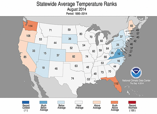
August 2014 Statewide Temperature ranks
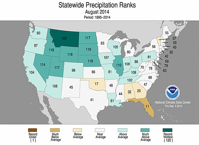
August 2014 Statewide Precipitation ranks
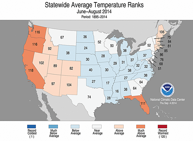
June-August 2014 Statewide Temperature ranks

June-August 2014 Statewide Precipitation ranks

January-August 2014 Statewide Temperature ranks

January-August 2014 Statewide Precipitation ranks
**A comparison of the national temperature departure from average as calculated by NCDC's operational dataset (nClimDiv), the U.S. Historical Climatology Network (USHCN), and the U.S. Climate Reference Network (USCRN) is available on our National Temperature Index page.**
Alaska Temperature and Precipitation:
- Temperature
- Alaska had its 4th warmest August since records began in 1918, with a temperature 3.03°F (1.68°C) above the 1971-2000 average.
- Alaska had its 14th warmest June-August since records began in 1918, with a temperature 1.00°F (0.56°C) above the 1971-2000 average.
- Alaska had its 3rd warmest January-August since records began in 1918, with a temperature 3.72°F (2.07°C) above the 1971-2000 average.
- Precipitation
- Alaska had its 43rd driest August since records began in 1918, with an anomaly that was 2.97% above the 1971-2000 average.
- Alaska had its 3rd wettest June-August since records began in 1918, with an anomaly that was 30.44% above the 1971-2000 average.
- Alaska had its 44th wettest January-August since records began in 1918, with an anomaly that was 9.61% above the 1971-2000 average.
For additional details about recent temperatures and precipitation across the U.S., see the Regional Highlights section below and visit the Climate Summary page. For information on local temperature and precipitation records during the month, please visit NCDC's Records page.
Regional Highlights:
These regional summaries were provided by the six Regional Climate Centers and reflect conditions in their respective regions. These six regions differ spatially from the nine climatic regions of the National Climatic Data Center.
- Northeast Region: (Information provided by the Northeast Regional Climate Center)
- August was another cooler-than-normal month in the Northeast. The region's average temperature of 66.6 degrees F (19.2 degrees C) was 1.6 degrees F (0.9 degrees C) below normal. Eleven of the region's twelve states saw below-normal temperatures, with departures ranging from -1.3 degrees F (-0.7 degrees C) in New Hampshire to -2.6 degrees F (-1.4 degrees C) in Maryland. Maine was the lone warmer-than-normal state at +0.3 degrees F (+0.2 degrees C). Summer overall was cooler than normal, too. The region's average temperature was 67.3 degrees F (19.6 degrees C), 0.4 degrees below normal. Ten states saw below-normal summer temperatures, with departures ranging from -0.1 degrees F (-0.1 degrees C) in Vermont to -1.1 degrees F (-0.6 degrees C) in Maryland. New Hampshire wrapped up the season at normal. Maine was 0.9 degrees F (0.5 degrees C) warmer than normal, making it the state's 15th warmest summer since recordkeeping began.
- The region was slightly drier than normal during August. The Northeast received 3.81 inches (96.77 mm) of rain, 97 percent of normal. Eight states were drier than normal, with departures ranging from 68 percent of normal in Rhode Island to 99 percent of normal in New Jersey. For the wet states, departures ranged from 110 percent of normal in Maryland to 123 percent of normal in Delaware. Summer, however, ended on the wet side of normal. The region picked up 13.67 inches (347.22 mm) of rain, 110 percent of normal. Eight states were wetter than normal, with three ranking the month among their top 20 wettest. Those states were: Maine, 10th wettest; New Hampshire, 15th wettest; and New York, 18th wettest. Departures ranged from 101 percent of normal in New Jersey to 122 percent of normal in Maine. Departures for the dry states ranged from 80 percent of normal in Connecticut to 99 percent of normal in West Virginia.
- Five percent of the Northeast (parts of New England, Long Island, and West Virginia) was experiencing abnormally dry conditions at the start of August, according to the U.S. Drought Monitor. While conditions improved in some areas, abnormal dryness was introduced in other areas. By month's end, six percent of the region (parts of southern New England, southeastern New York, and West Virginia) was abnormally dry.
- Extreme rainfall shattered records and caused significant flash flooding in parts of the Northeast from August 12-13. Numerous roads, including major highways, were submerged under feet of water, leaving cars stranded and leading to dozens of water rescues. Two long-term parking lots at Baltimore-Washington International Airport were partially flooded, as well. Baltimore, MD, saw over 6.30 inches (160.02 mm) of rain on the 12th, making it the highest amount of precipitation for any calendar day that was non-tropical based. Islip, NY, saw 13.51 inches (343.15 mm) of rain on the 13th. This was a 500-year storm event, meaning rainfall of that magnitude is only expected to occur once in a 500-year period. The site set a New York State 24-hour precipitation record (13.57 inches or 344.68 mm of rain fell in 24 hours), had its wettest August on record, and tied its all-time wettest month on record. Portland, ME, received 6.43 inches (163.32 mm) of rain on August 13, making it the greatest daily precipitation for any calendar day that was not associated with a tropical system. In addition, the site picked up 2.57 inches (65.28 mm) of rain from 9 PM to 10 PM, setting a new hourly record. Another 1.64 inches (41.66 mm) of rain fell from 10 PM to 11 PM. The consecutive two-hour rain total of 4.21 inches (106.93 mm) also set a record. Periods of heavy rain from August 20-23 caused flash flooding in several areas. Two weak tornadoes accompanied some of the storms on August 21 in Pennsylvania. On the last day of the month, severe storms produced a tornado in Massachusetts.
- For more information, please go to the Northeast Regional Climate Center Home Page.
- Midwest Region: (Information provided by the Midwest Regional Climate Center)
- August temperatures averaged within 1 to 2 degrees F (1 C) of normal across the Midwest. The month was not near normal throughout however. The first half of August continued the July pattern of cool temperatures but the second half of the month was then warmer than normal to bring the monthly average back close to normal. The warmth late in the month brought very warm temperatures, topping 100 degrees F (38 C) at several stations in Missouri, and high humidity to the region. Summer, June through August, temperatures were also close to normal across the region with warmth in June and late August offsetting cooler temperatures in July and early August.
- August precipitation was above average for much of the Midwest. Statewide precipitation totals ranged from near normal in Michigan to more than two inches (51 mm) above normal in Kentucky. There were areas within several states with well below normal totals however. Northern Minnesota, southern Missouri, and portions of Michigan, Iowa, and Ohio received between 25% and 75% of normal precipitation during the month. Totals ranged from just over and inch (25 mm) to more than 10 inches (254 mm) so the local impacts varied considerably based on where the rain fell. Despite the near normal monthly total for Michigan on a statewide basis, the Detroit area was hit with intense rains on August 11th when four to six inches (102 to 152 mm) fell in just eight hours. The downpour caused widespread flooding that even affected the interstate highways in the area.
- August rainfall helped to alleviate the few remaining areas of drought in the Midwest. With just 2.5 percent of the region in drought at the start of August, drought was not a major Midwest issue. The rains in August further reduced the impact on the region bringing the areal coverage to less than one percent by the end of the month. An additional seven percent of the region was classified as abnormally dry leaving 92 percent of the region unclassified by the US Drought Monitor.
- The cool summer temperatures have meant there was little heat stress on row crops during the hottest season of the year. Spotty rainfall meant that some areas were still impacted by dry conditions, but with adequate rainfall for most in the region, many areas reported much of their corn and soybeans in good or excellent condition, with some areas even anticipating record yields when harvest comes around.
- For details on the weather and climate events of the Midwest, see the weekly summaries in the Midwest Climate Watch page.
- Southeast Region: (Information provided by the Southeast Regional Climate Center)
- Mean temperatures in August were variable across the Southeast region. The greatest positive departures were found across north-central Florida and extreme southwestern Georgia, where monthly temperatures were 2 to 3 degrees F (1.1 to 1.7 degrees C) above average. Tallahassee, FL (1896-2014) observed its third warmest August on record, which included 19 days of 95 degree F (35 degree C) and greater temperatures. In contrast, August mean temperatures were significantly below average across central North Carolina and Virginia, with widespread anomalies reaching 3 to 4 degrees F (1.7 to 2.2 degrees C) below average. Roanoke, VA (1912-2014) observed its third coolest August on record, and 90 degree F (32.2 degree C) and greater temperatures occurred on only 1 day during the month. Mean temperatures were near average in Puerto Rico and the U.S. Virgin Islands during August. The warmest weather of the month occurred ahead of an unusually strong back door cold front on the 22th to the 24th over parts of northern Florida, Alabama, Georgia, and the Carolinas. Daily maximum temperatures reached the middle to upper 90s F (30s C), and several locations (e.g. Columbia, SC, Savannah, GA, and Tallahassee, FL) reported temperatures of at least 100 degrees F (37.8 degrees C). In addition, heat index values exceeded 100 degrees F across a large portion of the region during this period, with isolated locations approaching 110 to 115 degrees F (43.3 to 46.1 degrees C). The coolest weather occurred during the first two days of the month as an unseasonably strong upper air trough settled over the eastern United States. Daily mean temperatures were 10 to 15 degrees F (5.6 to 8.3 degrees C) below average over a broad portion of the region spanning east-central Georgia to central Virginia, with several locations setting daily records (e.g. Greensboro, NC, Boone, NC, Spartanburg, SC).
- Precipitation was highly variable across the Southeast region during August. The driest locations were found across much of the southern portion of the region, including central and northern Florida, central and southern Alabama, central Georgia, and central South Carolina. The Florida Panhandle was especially dry, with Pensacola (1879-2014) and Tallahassee recording only 1.37 and 2.26 inches (34.8 and 57.4 mm) of precipitation, about 20 and 30 percent of normal during August, respectively. Macon, GA (1892-2014) observed its second driest August on record with only 1.05 inches (26.7 mm) of precipitation, which is approximately 25 percent of normal. In contrast, the wettest locations were found across northwestern and eastern parts of North Carolina as well as southwestern Virginia, where monthly totals ranged from 8 to 10 inches (203 to 254 mm), or 150 to 250 percent of normal. Numerous reports of flash flooding in the Carolinas and Virginia occurred during the month of August. On August 12th, 1.15 inches (29.2 mm) of rainfall was recorded in 11 minutes at Raleigh-Durham International Airport (1887-2014), which corresponds to an average recurrence interval of about 100 years for a 10-minute total. Monthly precipitation totals were also well above normal across Puerto Rico and the U.S. Virgin Islands. San Juan (1898-2014) recorded 9.79 inches (249 mm) of precipitation during August, which is about 180 percent of normal. Much of this precipitation occurred during the passage of tropical cyclones Bertha and Cristobal.
- A total of 269 reports of severe weather across the Southeast occurred during August, and over 92 percent of these reports corresponded to damaging thunderstorm winds. On August 10th, estimated winds of 30 to 40 knots associated with the passage of a thunderstorm outflow boundary caused a boat to capsize along the Indian River in Brevard County, FL, resulting in two fatalities. Only three tornadoes were confirmed across the region during August. On the 15th of the month, an EF-0 tornado touched down in St. Lucie County, FL near the city of Fort Pierce, but no damage was reported. The next day, an EF-0 tornado touched down about 85 miles to the south in Palm Beach County, FL. On August 20th, an EF-1 tornado was confirmed in Murray and Gilmer County, GA, producing widespread downed trees and minor damage to local homes. On the 12th of the month, a person near Milton, FL was struck while leaning against a vehicle. Three days later, a USPS worker in Broward County, FL sustained serious burns from a lightning strike near his vehicle.
- Most of the Southeast region remained drought-free (less than D1) during the month of August, but conditions continued to worsen across portions of southern Georgia and the Florida Panhandle. Areas of severe drought (D2) were introduced across extreme southwestern and south-central parts of Georgia during the latter half of the month, covering approximately 11 percent of the state. In addition, areas of moderate drought (D1) expanded across parts of the Southeast, particularly southern Georgia, the Florida Panhandle, and central Alabama. By the end of the month, moderate drought conditions covered about 6 percent of the Southeast region, an increase from less than 1 percent at the beginning of August. However, relatively low humidity during August aided in the reduction of foliar (leaf-related) diseases on some crops in Georgia.
- For more information, please go to the Southeast Regional Climate Center Home Page.
- High Plains Region: (Information provided by the High Plains Regional Climate Center)
- August 2014 was a cool and wet month for most of the High Plains Region. A broad area of below normal temperatures encompassed Colorado, Wyoming, South Dakota, the southern half of North Dakota, and northern Nebraska. The largest departures of 2.0-4.0 degrees F (1.1-2.2 degrees C) occurred in northern Colorado, central Wyoming, central South Dakota, and southwestern North Dakota. On the warm side, areas of Kansas, southern Nebraska, and northern North Dakota had temperature departures which ranged from near normal to 3.0 degrees F (1.7 degrees C) above normal. Monthly temperature records were not broken this month. While overall this has been a great growing season across the Midwest, the continuation of cool weather may prove to be an issue for producers in northern parts of the Region this fall. A late start to the growing season combined with cooler conditions has put crop progress behind and harvest season is likely to be delayed due to high moisture in the corn. There is also some concern about whether these late planted crops will reach maturity before the first killing freeze. Excess moisture in fields was also an issue in some areas where wheat could not be harvested due to muddy conditions. Although not weather/climate related, another issue facing grain producers was the delay of shipments due to the increased rail traffic from the oil boom.
- Following a very dry July, the High Plains Region was quite wet this August. Large areas of the Region and surrounding areas received over 200 percent of normal precipitation. One area extended from Montana, Wyoming, and northwestern Colorado into western North Dakota and northern and central South Dakota. Other areas receiving heavy precipitation included southeastern North Dakota, south-central South Dakota, east-central Nebraska and western Iowa, and the northern part of the Nebraska panhandle. The only widespread dry areas were located in central Kansas and central Colorado. There were locations in each state which ranked in the top 10 wettest Augusts on record due to the widespread heavy precipitation. One of these locations was Kearney 4 NE, Nebraska which received 7.60 inches (193 mm) and ranked as the 2nd wettest August on record (period of record 1894-2014). 3.19 inches (81 mm) fell in just one day, August 9th, and the city of Kearney experienced flash flooding which not only impacted travel but also flooded the basement and cafeteria of the Good Samaritan Hospital. The August 9-10 total of 4.26 inches (108 mm) was the highest two-day precipitation total on record for the month of August. Another notable wet location was Dickinson, North Dakota which had its wettest August on record. Dickinson received 6.79 inches (17 mm) of precipitation which was 5.25 inches (13 mm) above normal, or 441 percent of normal! This crushed the old record of 5.55 inches (14 mm) set back in 1954 (period of record 1948-2014). Although just outside the Region, it is worth noting that a slow-moving storm system brought significant, record-breaking rainfall to central and eastern Montana at the end of August. Many locations had precipitation totals that matched or exceeded half their average annual totals. One example was Glasgow, which had its wettest August on record with 6.72 inches (171 mm) (period of record 1893-2014). For comparison, the normal precipitation for August is 1.24 inches (31 mm) and for the year is 11.66 inches (296 mm). The heavy rain not only led to flooding along the Milk River, but also negatively impacted barley and wheat crops. According to the United States Geological Survey's streamflow conditions map, high flows were present along the Missouri and its tributaries in areas of Montana and western North Dakota following these heavy rains.
- This summer, the High Plains Region went from one precipitation extreme to the other. June was wet across the eastern side of the Region with areas of the Dakotas, Nebraska, and Kansas receiving over 200 percent of normal precipitation. Localized areas experienced record-breaking precipitation which led to flooding issues. For instance, the Big Sioux River set a new streamflow record of 108,000 cfs on June 18th (period of record 1929-2014). Flooding along the Big Sioux closed I-29, washed out roads and bridges, and inundated farmland. Another notable record came from Canton, South Dakota which set a new record for most precipitation in any month for the whole state. The June total came to 19.65 inches (499 mm). July on the other hand was quite dry. This contrast was illustrated well with the state-wide precipitation rankings. Take South Dakota for instance, which went from 4th wettest June to 6th driest July. Luckily, July was also fairly cool and this unusual combination of cool, dry conditions helped stave off impacts from the dryness. After a reprieve, wet conditions returned in August and many locations ranked in the top 10 wettest Augusts on record. In Montana, nearly half the average annual precipitation of many locations fell in just a few short days. Other areas of western North Dakota, western South Dakota, western and central Wyoming, and portions of Nebraska dealt with heavy precipitation as well. As a whole, this summer was generally wet and cool, with only a few areas of dryness, mainly in Colorado and eastern Kansas. Many locations ranked in the top 10 wettest summers on record and a few locations in the Dakotas ranked in the top 10 coolest. For example, Pierre, South Dakota had its 6th coolest summer on record with an average temperature of 69.0 degrees F (20.6 degrees C). Another way to illustrate the cool weather is to look at the number of days with a maximum temperature of 90 degrees F (32.2 degrees C) or higher. This summer, Pierre only had 10 days with temperatures of 90 degrees F (32.2 degrees C) or higher. This came in well under the average of 36 days (period of record 1933-2014).
- Heavy rains led to improvements this month across the High Plains Region. Although the total area of the Region still in drought (D1-D4) remained about the same, there were some single category improvements in Kansas, Colorado, Nebraska, and South Dakota. The last remaining area of exceptional drought (D4) in eastern Colorado was downgraded to extreme drought (D3) and severe and extreme drought (D2 and D3, respectively) conditions improved in Kansas as well. The most significant decrease occurred in an approximate 10 percent reduction of D2 across Kansas. Additionally, a couple of areas of moderate drought (D1) improved in southeastern South Dakota and northeastern Nebraska. The only area to experience degradation was in extreme southeastern Nebraska and eastern Kansas where D1 emerged. According to the U.S. Seasonal Drought Outlook released August 21st much of the current drought conditions should improve or be removed. The only area where drought is expected to persist or intensify is the northwest corner of Colorado and south-central Wyoming.
- For more information, please go to the High Plains Regional Climate Center Home Page.
- Southern Region: (Information provided by the Southern Regional Climate Center)
- August average temperatures varied spatially across the Southern region. Central and eastern portions of the region experienced a slightly cooler than normal month, whereas much of Texas and western Oklahoma experienced a slightly warmer than normal month. The coldest departures from normal were observed in south western Arkansas, where stations averaged approximately two to four degrees F (1.11 to 2.22 degrees C) below normal. Conversely, stations in the southern tip of Texas averaged between two and three degrees F (1.11 and 1.67 degrees C) above expected values. Similar positive anomalies were also observed in the Trans Pecos Climate Division of Texas, and in the Texas and Oklahoma panhandles. The state wide average temperatures for August are as follows: Arkansas reported 78.80 degrees F (26.00 degrees C), Louisiana reported 81.50 degrees F (27.50 degrees C), Mississippi reported 79.90 degrees F (26.60 degrees C), Oklahoma reported 80.90 degrees F (27.16 degrees C), Tennessee reported 75.90 degrees F (24.39 degrees C), and Texas reported 82.70 degrees F (28.17 degrees C). All state rankings of temperature fell within the two middles quartiles.
- The August precipitation in the Southern Region tells a tale of extreme values, with very few stations reporting near normal precipitation totals for the month. Much of Louisiana experienced a very wet month, with precipitation totals ranging from 150 to 200 percent of normal. Similar values were recorded throughout much of Tennessee and southern Arkansas. Small portions of Texas also observed high precipitation totals for the month. This includes the southern tip and west central counties of the state. In Oklahoma and northern Arkansas, however, conditions were quite dry, with most stations reporting less than a quarter of the monthly normal. This was also the case for many counties in the south eastern and north western counties of Texas. The state wide average precipitation totals for the month of August are as follows: Arkansas recorded 2.83 inches (71.89 mm), Louisiana recorded 5.91 inches (150.11 mm), Mississippi recorded 3.46 inches (87.89 mm), Oklahoma recorded 1.53 inches (38.86 mm), Tennessee, recorded 5.01 inches (127.25 mm), and Texas recorded 1.71 inches (43.43 mm). For Tennessee it was the nineteenth wettest August on record (1895-2014), while Louisiana experienced its thirtieth wettest August on record (1895.-2014). Conversely, Oklahoma experienced its seventeenth driest August on record (1895-2014). All other state rankings fell within the two middle quartiles.
- Drought conditions in the Southern Region did not vary much over the past month. In northern Texas, dry conditions have led to a slight expansion of extreme drought, and there was also a slight expansion of severe and moderate drought in the central counties of Texas.
- August was a very quiet month for severe weather. There were no tornadoes reported throughout the month.
- In Texas, statewide, reservoirs continued to decline, dropping by nearly three percent. Several rural and industrial water supplies started new or updated existing water use restrictions, including Luling in Caldwell County, the Guadalupe-Blanco River Authority in Calhoun County, the Coolcrest and Fair Oaks Ranch Utilities in Bexar County, and Highland Park in Dallas County. Many suburbs of the Metroplex, including Lewisville, Allen, and Plano, have adjusted their restrictions to allow for outdoor watering on rotation through October. Groundwater out west is still a concern as well: the Edwards Aquifer J-17 test well dropped to 626 feet (191.11 m) above sea leavel during August, and springflows declined by over 10 percent. A new report out of Texas Tech estimates that the Ogallala Aquifer only has 15 years of usage at its current rate in west Texas, based on a decline of 100 feet (30.48 m) in the past 40 years, compared to roughly 40 feet (12.19 m) averaged across the whole aquifer; current estimates show that 30% of the High Plains economy – roughly $3 billion – could be impacted by the dropping aquifer levels. Crop progress through August was promising. Cotton, corn, sorghum, and rice all beat both last year's and their 5-year average marks for crop development, though they are behind in both in terms of harvesting. Soybeans, meanwhile, are behind their marks both compared to last year and the 5-year average. Cotton and peanuts have the highest percentage of poor to very poor report conditions, but most crops are fair to excellent overall. Continued dryness through central and south-central Texas has lead these areas to see few reports of adequate soil moisture, both at topsoil and subsoil levels. The High Plains have improved since the beginning of the summer, but still struggle with subsoil moisture shortages. Outside of the statistics, there are concerns over the future of the Texas rice belt, with new well drilling expected to drain groundwater at an unsustainable rate and ushering the end of rice crops in the Lower Colorado River Valley (Information provided by the Texas Office of State Climatology).
- For more information, please go to the Southern Regional Climate Center Home Page.
- Western Region: (Information provided by the Western Region Climate Center)
- An active monsoon circulation as well as the passage of several low-pressure systems produced above normal precipitation over much of the West this month. Temperatures were cooler than normal in a wide swath extending from southeastern California northeast to the Great Plains states while the Pacific Northwest and much of California experienced warmer than normal temperatures.
- High pressure dominated over the Pacific Northwest this month producing average temperatures 2-6 F (1-3 C) above normal. In northwestern Oregon, Salem recorded its warmest August in a 122-year record at an average 72.5 F (22.5 C). August's warm temperatures helped several locations in northern California and southwest Oregon achieve one of their top-10 hottest summers (June-August) on record. Temperatures averaged to 75 F (23.9 C) in Medford, Oregon, the hottest summer since records began in 1911. The previous record of 74 F (23.3 C) was set in 2013. In northern California, Montague reported an average 72.9 F (22.7 C) for the summer, the warmest in a 67-year record. August was the third warmest on record at Medford (77 F, 25 C) and the second warmest at Montague (73.7 F, 23.2 C). Cool air brought in by passing low-pressure systems as well as cloudiness associated with monsoonal precipitation helped moderate temperatures in the Southwest east of the Sierra Nevada and in the central and southern Rockies. Average August temperatures in these regions were 1-4 F (1-2 C) below normal.
- During August's first week, an upper level low over the Great Basin combined with a surge of monsoon moisture resulted in well above normal precipitation for many Great Basin locations. Reno recorded 1.03 in (26 mm) on the 4th and 5th; their August total of 1.08 in (27 mm) was 470% of normal, tied with 2013 for the 4th wettest August on record. Farther east, copious precipitation fell in southern Idaho on the 5th and 6th and again from the 20th-25th when monsoonal moisture interacted with another slow-moving upper level low. Twin Falls, Idaho, recorded 5.57 in (141 mm) for the month, 5.25 in (133 mm) above normal and by far the wettest August on record and the wettest of any calendar month at any station in the Magic Valley. These systems also brought very heavy precipitation to much of Montana. Saco, in the northeastern part of the state, observed a record 10.41 in (264 mm), nearly triple the previous August record of 3.51 in (89 mm) set in 1975; records there began in 1966. A low-pressure system passing over the Pacific Northwest on the 12th-15th helped to initiate thunderstorms in the region, resulting in above normal precipitation in parts of eastern Washington and Oregon. During this period, Ephrata, Washington, collected its total precipitation for the month of 0.83 in (21 mm), 437% of normal and tied for 4th wettest August in a 66-year record. Some areas of the desert Southwest saw above normal precipitation as well. Needles, in the Mojave Desert, recorded 2.22 in (56 mm) this month, 560% of normal. This summer has been the wettest in Needles' 67-year record with a total 4.43 in (113 mm) of precipitation. This month's precipitation improved drought conditions in southeastern California and western Arizona as well as parts of the central and northern Great Basin; however, large areas of extreme to exceptional drought remain in California, Nevada, and Oregon. As is typical for August, coastal locations saw little to no rainfall. Portions of New Mexico and Colorado saw drier than normal conditions as well.
- In Hawaii, the windward side of the Big Island saw heavy precipitation in the beginning of the month associated with Tropical Storm Iselle. Hawaii Volcanoes National Park, at 3970 ft (1210 m) on the southeast side of the island, recorded 12.29 in (312 mm) of rainfall on August 8 alone. This was the 5th wettest day since the station began recording data in 1949. To the north, southeastern Alaska saw showery weather. Yakutat logged 23.17 in (589 mm) precipitation this month, 165% of normal and the 8th wettest August in a 98-year record. Temperatures were slightly above normal in Interior Alaska and considerably above normal in the far western portion of the state. Kotzebue saw an average temperature of 58.4 F (14.7 C) this month, 6.6 F (3.7 C) above normal and the 3rd warmest August on record. Records for Kotzebue began in 1897.
- August (all month): Heavy precipitation damages Idaho crops: Three Idaho counties have requested USDA disaster declarations due to crop damage from this month's extreme precipitation. Wheat and barley crops were most affected since they were mature and nearing harvest.
- August 7: Tropical Storm Iselle makes landfall in Hawaii: Iselle was the strongest tropical cyclone to make landfall on the Big Island in recorded history. Iselle reached peak intensity on August 4th as a category 4 hurricane, then weakened to a tropical storm just before making landfall on August 7. Iselle caused significant crop damage including losses to papaya operations estimated at $53 million. One death was reported due to flooding on Kauai.
- August 19: Flash flooding in Yavapai County, Arizona: Heavy monsoonal rainfall flooded portions of Yavapai County (north of Phoenix). Fifteen miles of Interstate 17 were inundated and rock slides along the highway caused several vehicle collisions. Over 40 water rescues occurred throughout the day along with isolated major property damage.
- For more information, please go to the Western Regional Climate Center Home Page.