National Overview:

- Climate Highlights — January
- The average temperature for the contiguous U.S. during January was 32.0°F, 1.6°F above the 20th century average, tying with 1958 as the 39th warmest January on record.
- January brought Florida both had their 11th warmest January with monthly temperatures 5.7°F and 5.6°F above average, respectively.
- Utah had its eighth coolest January, with temperatures 7.5°F below average.
- The January nationally-averaged precipitation total of 2.36 inches was 0.14 inch above the long-term average. The January precipitation average masked both wet and dry extremes across the nation. Drought conditions remained entrenched across the Southeast, Great Plains, and the mountainous West.
- Virginia each had January precipitation totals ranking among their ten wettest. The above-average precipitation generally missed the core drought areas of the central and southeastern United States.
- Florida each had one of their ten driest Januarys.
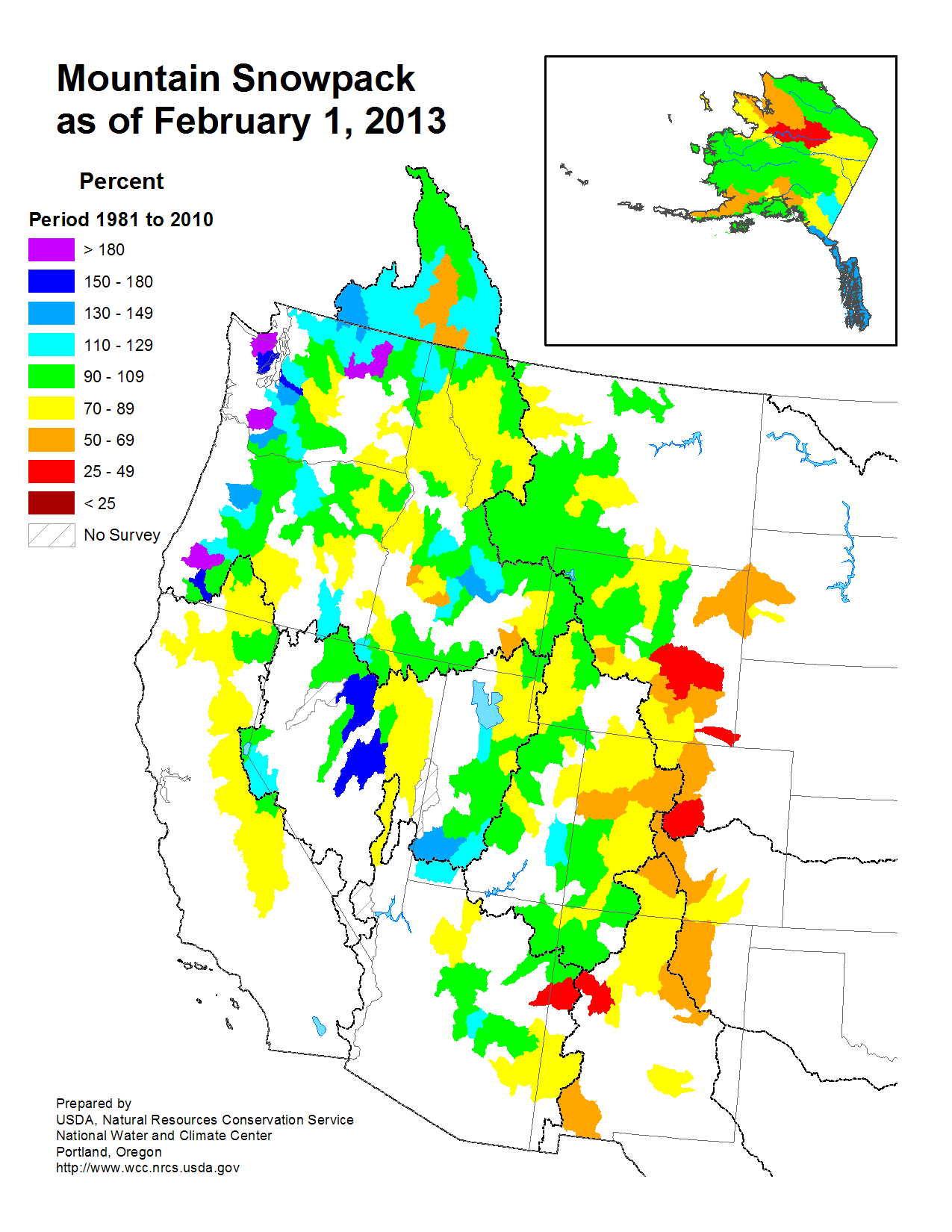
- According to data from the Rutgers Global Snow Lab, the January snow cover extent for the contiguous U.S. was slightly above average at 1.4 million square miles. Mountain snowpack was near-average for much of the West, with the exceptions in parts of the Northwest where snowpack was much above average, and in the Central and Southern Rockies where snowpack was much below average.
- Alaska was warmer and wetter than average. The statewide average temperature was 7.1°F above average and the precipitation total was 64 percent above average. Parts of the state had monthly temperatures more than 10°F above normal.
- According to the January 29th U.S. Drought Monitor report, 57.7 percent of the contiguous U.S. was experiencing moderate-to-exceptional drought, smaller than the 61.1 percent at the beginning of the month. Drought conditions improved in parts of the Mid-Atlantic and Mid-Mississippi River Valley.
- Climate Highlights — Winter to Date (December 2012 — January 2013)
- The first two months of the winter season, December and January, were warmer than average for the contiguous U.S. and ranked as the 18th warmest such 2-month period on record. December-January had an average temperature 2.5°F above average. Much of the warmth occurred across the eastern half of the nation. The West Coast and Southwest were slightly cooler than average during the 2-month period.
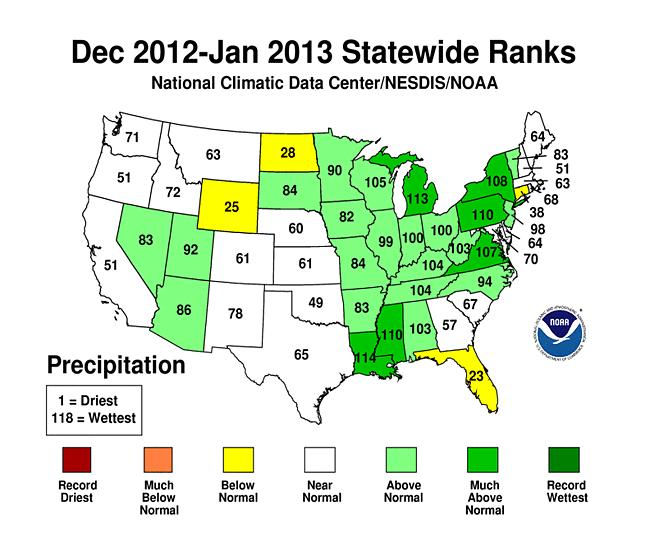
- An active storm pattern in the eastern U.S. resulted in wetter-than-average conditions during the first two months of winter. Louisiana, Mississippi, Michigan, and Pennsylvania each had a top ten wet period. The nationally-averaged precipitation total for the two-month period was 5.10 inches, 0.65 inch above average.
- Climate Highlights — Last 12 months (February 2012 — January 2013)
- The 12-month period, ending in January, was the warmest such period for the contiguous U.S., with 27 additional states were top ten warm. The February-January nationally-averaged temperature of 55.0°F was 2.9°F above average and the ninth warmest of any 12-month period on record for the nation.
- The nationally-averaged precipitation total of 26.95 inches for the February-January period was 2.19 inches below average. Much of the Louisiana had a top ten wet period.
Alaska Temperature and Precipitation:
 Alaska
had its 12th warmest January since records began in 1918, with a temperature 7.1°F (3.9°C) below the 1971–2000 average.
Alaska
had its 12th warmest January since records began in 1918, with a temperature 7.1°F (3.9°C) below the 1971–2000 average. Alaska
had its 47th warmest November-January since records began in 1918, with a temperature 0.5°F (0.3°C) below the 1971–2000 average.
Alaska
had its 47th warmest November-January since records began in 1918, with a temperature 0.5°F (0.3°C) below the 1971–2000 average.-
 Alaska
had its 11th wettest January since records began in 1918, with an anomaly that was 64.0 percent above the 1971–2000 average.
Alaska
had its 11th wettest January since records began in 1918, with an anomaly that was 64.0 percent above the 1971–2000 average.  Alaska
had its 39th wettest November-January since records began in 1918, with an anomaly that was 7.5 percent above the 1971–2000 average.
Alaska
had its 39th wettest November-January since records began in 1918, with an anomaly that was 7.5 percent above the 1971–2000 average.
For additional details about recent temperatures and precipitation across the U.S., see the Regional Highlights section below and visit the Climate Summary page". For information on local temperature and precipitation records during the month, please visit NCDC's Records page. For details and graphics on weather events across the U.S. and the globe please visit NCDC's Global Hazards page.
Regional Highlights:
These regional summaries were provided by the six Regional Climate Centers and reflect conditions in their respective regions. These six regions differ spatially from the nine climatic regions of the National Climatic Data Center.
- Northeast Region: (Information provided by the Northeast Regional Climate Center)
- The trend of warmer-than-average temperatures in 2012 continued right into 2013. The Northeast’s average temperature of 26.5 degrees F (-3.1 degrees C) was 2.9 degrees F (1.6 degrees C) above normal but 1.2 degrees F (0.7 degrees C) cooler than January 2012. It was the 27th warmest January in 119 years. All states were warmer than normal with seven of the twelve states reporting January 2013 as one of their top 30 warmest. Delaware was the warmest state at 38.8 degrees F (3.8 degrees C). It was 4.3 degrees F (2.4 degrees C) above average and the state’s 17th warmest January. Departures for the rest of the states ranged from +1.8 degrees F (1.0 degrees C) in New Hampshire to + 3.6 degrees F (2.0 degrees C) in Vermont.
- January 2013 was drier than normal in the Northeast. The region’s monthly precipitation of 2.54 inches (64.52 mm), 82 percent of normal, was 0.53 inches (13.46 mm) below average. Nine states were drier than normal with departures ranging from 39 percent of normal in Connecticut to 88 percent of normal in New Jersey. Several states had Januarys that ranked in their top 25 driest: Connecticut, 9th driest; Maine and Rhode Island, 11th driest; Massachusetts, 13th driest; New Hampshire, 16th driest; and Vermont, 23rd driest. Two states received near-average precipitation with Pennsylvania coming in at 100 percent of normal and Maryland at 101 percent of normal. West Virginia was the wettest state at 135 percent of normal making it their 30th wettest January since 1895.
- Arctic air settled into the Northeast from the 22nd through the 25th. Temperatures were 15 to 20 degrees F (8.3 to 11.1 degrees C) below average. The cold air moving over the relatively warm waters helped create major lake-effect snowfall east of Lakes Erie and Ontario. The greatest totals along Lake Erie were found in Chautauqua County, NY, where around 2 feet (61 cm) of snow fell. Along Lake Ontario the greatest snowfall amounts were in Oswego and Cayuga counties of New York where around 3 feet (91.4 cm) fell. A powerful low pressure system moved through the Northeast from the 30th to the 31st. In advance of the low, warm southerly air helped twenty climate sites set record high temperatures. As the system advanced, sustained winds as high as 49 mph (21.9 m/s) with gusts as high as 81 mph (36.2 m/s) brought down trees and power lines, ripped off parts of roofs, and blew out windows. Heavy rain (6.12 inches (155.45 mm) fell in Damascus, MD) caused flash flooding with numerous road closures and water rescues reported. As cold air moved in behind the system, lake-effect snow was yet again generated with reports of up to 21 inches (53.3 cm).
- For more information, please go to the Northeast Regional Climate Center Home Page.
- Midwest Region: (Information provided by the Midwest Regional Climate Center)
- January temperatures were above normal across the Midwest. Statewide temperature departures ranged from 3 degrees F (2 C) to 5 degrees F (3 C) above normal. Despite the above normal temperatures for the month, there were several pushes of cold Arctic air that reached the Midwest in January. The coldest air arrived on the 19th and persisted for several days. Temperatures dropped below -40 degrees F (-40 C) in Minnesota, below -20 degrees F (-29 C) in Wisconsin and Michigan, below -10 degrees F (-23 C) in Iowa, and below 0 degrees F (-18 C) in Illinois, Indiana, and Ohio during the cold snap.
- January precipitation was near normal in Iowa, Minnesota, and Ohio and well above normal in the other Midwest states. Precipitation ranged from about 140 percent of normal to about 200 percent of normal. Indiana and Illinois were the wettest states with twice their normal precipitation totals for the month. Much the precipitation fell in the last few days of the month with a large portion of the region receiving from 1 to 3 inches (25 to 76 mm). Snowfall for January was below normal for most of the Midwest. Upper Michigan, northeast Wisconsin, and northwest Minnesota were the only areas with above normal snowfall for the month.
- Severe weather returned to the Midwest on the 12th and then again in the last few days of the month. On the 12th, there were a handful of severe thunderstorm reports along with an EF2 tornado near Livingston, Kentucky. The tornado damaged two churches. On the 29th and 30th, the southern half of the Midwest had widespread thunderstorm wind damage reported along with several tornadoes. The tornadoes were reported in Missouri, Illinois, Indiana, and Kentucky and ratings ranged from EF0 to EF2. Two people were injured by an EF2 tornado that hit Galatia, Illinois and two others were injured by an EF0 tornado that struck near Bradfordsville, Kentucky.
- Winter conditions caused hundreds of accidents across the Midwest. Five accidents each included dozens of vehicles and completely shut down the highways for hours. Two pileups happened on the 21st in southwest Ohio. The first involved 86 vehicles on Interstate 275 near Cincinnati, Ohio with one fatality and at least 20 others sent to hospitals for their injuries. The second involved about 50 vehicles on Interstate 70. On the 31st, a mile long accident on Interstate 75 near Detroit, Michigan killed three people and at least 20 were injured and transported to hospitals. Just west of Indianapolis on Interstate 70, dozens of vehicles were involved in a chain reaction wreck that killed one and injured at least ten. The third big accident on the 31st occurred outside Flint, Michigan on US Highway 23, involved 32 vehicles, and caused 12 injuries.
- For details on the weather and climate events of the Midwest, see the weekly summaries in the Midwest Climate Watch page.
- Southeast Region: (Information provided by the Southeast Regional Climate Center)
- Mean temperatures were above average across the Southeast in January. The greatest departures were found across South Carolina, Georgia, and Florida, where monthly temperatures were 6 to 8 degrees F (3.3 to 4.4 degrees C) above average, while monthly temperatures were 3 to 5 degrees F (1.6 to 2.8 degrees C) above average across Virginia, North Carolina, Alabama, and South Florida. Monthly temperatures were generally above average across Puerto Rico and near average across the U.S. Virgin Islands. The warmest weather occurred between the 12th and 17th of the month, with maximum temperatures exceeding 70 degrees F (21.1 degrees C) as far north as central Virginia and as high as 80 degrees F (26.7 degrees C) along the North Carolina coast. Overnight temperatures were also warm during this period, as more than 500 daily high minimum temperature records were tied or broken, including a few monthly records. Huntsville, AL (period of record: 1907-2013) and Milledgeville, GA (1891-2013) recorded monthly record high minimum temperatures of 65 degrees F (18.3 degrees C) on the 12th and 17th, respectively. The following week, a surge of Arctic air overspread much of the Southeast. Maximum temperatures failed to reach 40 degrees F (4.4 degrees C) across much of Virginia and North Carolina from the 22nd to the 27th of the month, while overnight temperatures dipped below freezing as far south as the Florida Panhandle between the 23rd and 25th of the month. The end of January saw a return of above average temperatures across much of the Southeast. On the 30th, Jacksonville, FL recorded a monthly record high maximum temperature of 85 degrees F (29.4 degrees C), breaking the old record of 84 degrees F (28.9 degrees C) last set in 1982 (period of record: 1871-2013).
- Precipitation in January was highly variable across the Southeast region. Monthly totals were above normal in a swath extending from central and northern Alabama through northern sections of Georgia and South Carolina, western North Carolina, and much of Virginia. The wettest locations were found across western sections of North Carolina and Virginia, where monthly totals exceeded 15 inches (381 mm). Highlands, NC, located in Macon County, recorded its third wettest January on record with 15.42 inches (391.17 mm) (period of record: 1905-2013), while Asheville, NC recorded its second wettest January on record with 8.58 inches (217.93 mm) (period of record: 1869-2013). Most of this precipitation fell between the 14th and 18th of the month. Daily rainfall totals during this period exceeded 5 inches (127 mm) along the eastern slopes of the Appalachian Mountains. Across the region, major flooding was reported in parts of western North Carolina and northern Georgia. Heavy rainfall was also observed at the end of the month in association with a slow-moving frontal boundary. Some locations in western North Carolina recorded between 5 and 6 inches (127 and 152.4 mm) of rainfall from the 30th to the 31st, resulting in flash flooding in places such as Boone, NC and Asheville, NC. In contrast, monthly precipitation was well below normal across eastern sections of South Carolina and Georgia, and most of Florida, Puerto Rico, and the U.S. Virgin Islands, with monthly totals less than 25 percent of normal. Augusta, GA (period of record 1871-2013) and Charleston, SC (period of record: 1938-2013) recorded their driest January on record with monthly totals of 0.60 and 0.35 inches (15.2 and 8.9 mm), respectively.
- The Southeast was impacted by two winter storms in January. The first occurred on the 17th and 18th of the month. Between 1 and 2 inches (25.4 and 50.8 mm) of snow fell across central portions of Alabama, and up to 5 inches (127 mm) was reported across the northern tier of the state. Snowfall totals ranged from 1 to 6 inches (25.4 to 152.4 mm) across central portions of North Carolina and Virginia, while up to 15 inches (381 mm) were recorded along the higher elevations of the Southern Appalachians. Trace amounts of snow were also reported in the Upstate of South Carolina. The second event occurred on the 25th of the month and resulted in a mix of snow, sleet, and freezing rain across central North Carolina and mostly snow across western North Carolina and much of Virginia. Snowfall totals ranged from less than an inch (25.4 mm) across central North Carolina to as much as 6 inches (152.4 mm) across eastern sections of Virginia. Ice accumulations were generally less than 0.2 inches (5.1 mm) across central North Carolina, with some reports of glaze across northern Georgia and South Carolina.
- There were 269 reports of severe weather across the Southeast in January, including seven confirmed tornadoes that occurred as part of an outbreak on the 30th of the month. The strongest tornado was an EF-3 that tracked for approximately 22 miles (35 km) across Bartow and Gordon Counties in northwest Georgia, approximately 50 miles (82 km) northwest of Atlanta. According to surveys conducted by the National Weather Service in Peachtree City, as many as 268 homes were damaged by the tornado, 30 of which were completely destroyed. The greatest damage was observed in the town of Adairsville in Bartow County. In addition, several cars and trucks were blown over as the tornado tracked across I-75. There has been one confirmed fatality and 17 injuries from this tornado. A second tornado was confirmed in Gilmer and Fannin Counties in extreme northern Georgia. This tornado was rated an EF-1 and resulted in hundreds of snapped and uprooted trees and power lines. The remaining five tornadoes were confirmed across central and northern Alabama, including four EF-1s and one EF-0. There were no additional casualties confirmed from these tornadoes. The weather system that contributed to the tornadoes also produced widespread damaging winds across the northern tier of the region.
- The heavy rainfall across the interior of the region helped eliminate drought conditions across northern parts of Alabama and Georgia, western North Carolina, and parts of central Virginia. Drought conditions also improved across parts of central North Carolina, eastern Alabama, and western Georgia. On the other hand, the lack of rainfall in January contributed to a re-emergence of abnormally dry (D0) conditions across central Florida and an intensification of drought across southeastern Georgia, the Florida Panhandle, and along the Savannah River watershed at the border of Georgia and South Carolina. On the 9th of the month, 92 counties in Georgia received designation as natural disaster areas due to losses and damages from the on-going drought. Across Florida, the warm, dry weather in January aided the growth of strawberries and helped farmers prepare for spring planting. However, several fruit trees did not receive adequate chill hours and the lack of rain continued to limit the growth of citrus trees and winter forage. There was also concern that the early blooming of some plants and trees will make them susceptible to a late winter or early spring freeze.
- For more information, please go to the Southeast Regional Climate Center Home Page.
- High Plains Region: (Information provided by the High Plains Regional Climate Center)
- The January 2013 nationwide picture showed that the eastern U.S. generally experienced above normal temperatures while the western U.S. had below normal temperatures. Average temperatures across the High Plains Region were generally near normal, except for western areas of Colorado and Wyoming. In fact, the western half of Colorado had some of the largest departures in the Region with average temperatures ranging from 6.0-13.0 degrees F (3.3-7.2 degrees C) below normal. This caused many stations to rank in the top 10 coolest Januarys on record. Grand Junction, Colorado had its 5th coolest January with an average temperature of 14.3 degrees F (-9.8 degrees C), which was 13.1 degrees F (7.3 degrees C) below normal (period of record 1893-2013). The coolest January occurred in 1973 with an average temperature of 11.5 degrees F (-11.4 degrees C). In addition, Alamosa, Colorado had its 4th coolest January on record with an average temperature of only 4.6 degrees F (-15.2 degrees C) which was 11.7 degrees F (6.5 degrees C) below normal. The 1992 record of 1.4 degrees F (-17.0 degrees C) held firmly (period of record 1906-2013). Storm systems pushing through the Region brought both cold air down from Canada and warm air up from the south. This led to a wide range of temperatures and to many new daily record highs and lows. For example, Topeka, Kansas set its all-time January record high with 77 degrees F (25.0 degrees C) on the 28th. The old record of 74 degrees F (23.3 degrees C) occurred on January 8, 2003 and January 2, 1939 (period of record 1887-2013).
- Precipitation was hit or miss across the High Plains Region this month. Because winter precipitation is generally light, there was little to no change in the drought regardless of whether a location received ample precipitation or not. Overall precipitation varied widely as totals ranged from 0 to 400 percent of normal. Above normal precipitation was concentrated in north central Wyoming, southwestern Colorado, southwestern and central South Dakota, and central and southeastern Kansas. The precipitation totals were not record breaking; however a few locations managed to get into the top 5 wettest Januarys on record. Howard 5 NE, located in southeastern Kansas, had its 4th wettest January on record with 2.81 inches (71 mm) of liquid equivalent precipitation. The record set in 1949 held at 5.40 inches (137 mm) of liquid equivalent precipitation (period of record 1907-2013). Meanwhile, other areas of the Region received little to no precipitation. Rock Springs, Wyoming had its driest January on record with only a trace amount of precipitation. The old record of 0.02 inches (1 mm) was set in 2004 (period of record 1948-2013). Several systems affected the Region this month, bringing a wide range of temperatures and precipitation types including snow, sleet, freezing rain, and rain (some of which fell from thunderstorms). One storm to hit the Region occurred on the 11th and 12th. This was the first significant storm to hit the Black Hills, although the storm impacted each state in the Region. The heaviest snow totals in southwest South Dakota ranged from 6.0-11.0 inches (15-28 cm), while the heaviest snows in North Dakota occurred in the eastern portion of the state with 5.0-8.0 inches (13-20 cm). According to the National Weather Service in Dodge City, Kansas, this system even created a dust storm out ahead of the cold front in eastern Colorado and western Kansas. This caused visibilities to drop near zero on I-70. Another storm at the end of the month brought record breaking warmth to parts of Kansas, dangerous wind chills of -25 to -50 degrees F (-31.7 to -45.6 degrees C) to the Dakotas, and wintry precipitation in between. For instance, in eastern Nebraska, snowfall totals ranged from 2.0-8.0 inches (5-20 cm) and caused issues as portions of I-80 were closed due to blowing snow and numerous schools closed. The first severe weather of the year was also associated with this storm as high winds were reported in southeastern Kansas. One area of concern this month was the snowpack in the Rockies, which was below average. Fortunately, the snow season is far from over for the Rockies and much more snow can accumulate later in the snow season. By the end of the month, Wyoming’s statewide snowpack was 76 percent of average and Colorado’s statewide snowpack was 75 percent of average. In contrast, last year’s statewide snowpack was 112 percent of normal in Wyoming. According to the Billings Gazette, the snowpack in some basins in Wyoming was low enough to negatively impact the skiing industry. Meanwhile, the snowpack in Colorado actually increased by 17 percent the last week of the month. According to The Denver Post, even with this increase, January’s snow pack was the 8th lowest out of 32 years.
- As expected for this time of year, there was little change to the U.S. Drought Monitor over the past month. Approximately 92 percent of the Region was still in moderate (D1) to exceptional (D4) drought. This was down slightly from the end of last month when 93 percent of the Region was in D1-D4. The only improvement was in north-central North Dakota where much of the abnormally dry conditions (D0) were erased. Drought conditions worsened in Colorado where the snowpack was significantly behind. The last holdout of D1 in the north-central part of the state deteriorated to severe drought (D2). In addition, extreme drought (D3) expanded slightly in the west-central part of the state. Those changes have put the entire state of Colorado in D2-D4. Drought conditions in the remaining states in the Region did not change with Nebraska leading the way with 77 percent of the state in D4. According to the U.S. Seasonal Drought Outlook released January 17th, drought conditions were expected to improve in North Dakota, northern South Dakota, and northern Wyoming. Drought was expected to persist elsewhere through April 2013.
- For more information, please go to the High Plains Regional Climate Center Home Page.
- Southern Region: (Information provided by the Southern Regional Climate Center)
- January proved to be another consecutive warm month for the Southern Region. Temperatures throughout the region averaged between 0 to 6 degrees F (0 to 3.33 degrees C) above normal, with temperature anomalies increasing from west to east. The only exception to this was in the western panhandle of Texas and along the Texas western border, where temperatures averaged slightly below normal. The warmest anomalies were observed in Mississippi and southern Tennessee. All state temperature rankings were on the warm side of normal, but all fell within the middle two quartiles. The state-wide average temperatures were as follows: 41.70 degrees F (5.39 degrees C) in Arkansas, 52.20 degrees F (11.22 degrees C) in Louisiana, 48.50 degrees (9.17 degrees C) in Mississippi, 39.70 degrees F (4.28 degrees C) in Oklahoma, 41.00 degrees F (5.00 degrees C) in Tennessee, and 47.70 degrees F (8.72 degrees C) in Texas.
- January was a very wet month for most of the Southern Region. A majority of stations throughout the region reported precipitation totals that were well above the monthly normal. There were some areas in the region that received less than normal precipitation. This includes much of central and western Oklahoma, southern Texas, and a small pocket in north central Texas. Elsewhere, most stations reported over 150 percent of normal precipitation. The highest anomalies were observed in in the western panhandle of Texas, where stations reported over three times the monthly normal. Because this is a fairly dry region, precipitation totals ranged only from 2 to 4 inches (50.80 to 101.60 mm). The highest precipitation totals for the country occurred in southern Louisiana and along the Louisiana-Mississippi border. Many stations in this area reported monthly totals of over 10 inches (254 mm), with some stations reporting over 20 inches (508 mm). The state of Louisiana averaged 11.20 inches (284.5 mm) of precipitation, which makes it the second wettest January there on record (1895-2013). Mississippi experienced their ninth wettest January on record, with a state wide precipitation total of 9.29 inches (236.00 mm). Conditions were also quite wet in Tennessee, where a state wide precipitation total of 8.81 inches (223.80 mm) was reported, or the eighth wettest January on record (1895-2013). For Arkansas, it was their eighteenth wettest January on record (1895-2013), with a state wide precipitation total of 6.15 inches (156.20 mm). The state of Texas averaged 2.64 inches (67.06 mm) of precipitation, while Oklahoma averaged 1.85 inches (46.99 mm) of precipitation. For Texas, it was the sixteenth wettest January on record (1895-2013), while for Oklahoma it was their thirty-eighth wettest.
- Despite high precipitation totals, drought conditions did not change too much over the past month. This is due in part to the fact that much of the heavy rainfall occurred in areas that were not experiencing drought, such as in Louisiana, Tennessee and Mississippi for example. High precipitation totals in Arkansas did result in about a one category improvement, but much of the northwest portions of the state remain in moderate to extreme drought. In central Texas, above normal precipitation did result in some improvement, but a little over half the state is still experiencing severe drought conditions or worse.
- A tornado in De Soto Parish, Louisiana resulted in two injuries on January 12. The twister was classified as an EF-1.
- On January 29, dozens of tornadoes and wind events were reported over an area ranging from northern Louisiana to central Tennessee. In Tennessee, two people were injured by tornadoes. One injury occurred in Dickson County, while the other occurred in Robertson County. Damages from these twisters are yet to be fully assessed, however; there were numerous reports of structural damage to barns, buildings and homes.
- Heavy rainfalls in southern Louisiana resulted in some significant flash flooding events. Flooding was observed in several Parishes in the southeastern part of the state, and Governor Bobby Jindal declared a state of emergency on January 10. HLNTV reported that hundreds of people were evacuated from their homes.
- In Texas, flooding from excessive rainfall earlier in the month presented problems in Dallas, Fort Worth, Houston, and Snook. Intermittent snowfall caused a fair amount of vehicular damage as well, generally from accidents caused by snow, sleet, and freezing rain or potholes and roadway damage caused by freezing temperatures (Information provided by the Texas Office of State Climatology).
- For Texas, many AgriLife Extension agents expect that the January rainfall, while not ensuring a successful harvest, did prevent winter wheat from being lost entirely, with some believing it saved over a million dollars. Cotton farmers are less fortunate, with initial yield estimates dropping by 500,000 due to the persistently dry conditions across most of the state. While snow cover in the western parts of the state have farmers cautiously optimistic, the long-term conditions are so poor that it’s not believed that the melt water will be enough to replenish soil moisture. With soil moisture conditions so poor, ranchers are still having trouble keeping their herds fed, causing the Cargill Meatpacking Plant in Plainview to lay off 2000 workers. Longer-term ecological damage has also been seen in recent months, culminating in the Wildlife Department falling short $4.6 million last year (Information provided by the Texas Office of State Climatology).
- Despite high precipitation totals in Texas, many regions are still suffering from low water supply, notably west Texas. The Lower Colorado River Authority enacted emergency conservation plans in January, and various levels of government are attempting to tackle the problem. Potential solutions include implementation of a 100-year plan in Lubbock estimated to cost anywhere between $4.1 and $10 billion, and a $2 billion appropriation plan introduced in the state legislature (Information provided by the Texas Office of State Climatology).
- For more information, please go to the Southern Regional Climate Center Home Page.
- Western Region: (Information provided by the Western Regional Climate Center)
- Unusually cold conditions dominated the West, especially in the interior, this month as strong inversions developed in the Great Basin and other low-lying areas. These inversions resulted from widespread snow cover established in December and intrusion of cold air masses followed by persistent ridges of high pressure at upper levels. These conditions prohibited vertical mixing and horizontal flow, resulting in poor air quality and record low temperatures in affected areas. Precipitation was below normal for much of the region, though with several pockets above average in the Southwest and Montana.
- Precipitation in the conterminous West was generally confined to two events this month. The first occurred over the 4th-12th and brought 10.2 in (26 cm) of snow to Salt Lake City, Utah and 24-36 in (60-90 cm) of snow to the northern portion of Utah’s Wasatch Range between the 10th and 12th. Salt Lake City received a total 23.8 in (60 cm) snowfall for the month, 190% of normal and the city’s 13th snowiest January since records began in 1874. The second event began on the 24th in conjunction with a plume of subtropical moisture over the Southwest. On January 26th, a weather balloon sounding at Phoenix, Arizona showed the most moisture present in the atmosphere of any January day since balloon launches began there in 1950. Phoenix recorded its 7th wettest January day in a 118-year record on the 26th at 1.18 in (30 mm). Portions of southeastern California, southeastern Utah, Arizona, and southwest Colorado also received a majority of their January precipitation from this event. Outside that area, dry conditions prevailed. Of note in the southern Great Basin was only trace of snowfall on Mt. Charleston near Las Vegas, Nevada where normal January snowfall is 21.9 in (56 cm). This month ties January 2003 for the least January snowfall at Mt. Charleston. Snow water equivalent in the Sierra Nevada snowpack started the month near 140% of normal and ended the month close to 90% of normal for the date. Despite daily record snowfalls and above normal precipitation in the northern and southern reaches of Montana, statewide precipitation averaged approximately 0.2 in (5 mm) below normal this month. This breaks a trend of above normal precipitation since October that followed a very dry spring and summer.
- Frigid air settled into the Great Basin and other interior valleys this month. Salt Lake City, Utah, at an average 19.4 F (-7 C), experienced its coldest month since 1949 and 6th coldest January since records began in 1874. Their normal January temperature is 29.5 F (-1.4 C). There are an average 9.4 days below freezing at Salt Lake City in January, but in this past month 22 days failed to reach the freezing mark. This total remains a few days behind January 1949 where 26 days had sub-freezing highs. Grand Junction, Colorado had not recorded more than 21 sub-0 F (< -17.8 C) lows in a winter until hitting its 22nd of the season at -3 F (-19.4 C) on January 22nd with almost two months of winter remaining. Grand Junction also saw its 4th longest stretch of sub-freezing highs at 22 days from December 19-January 9. Freezes affected California’s citrus January 10-14, prompting farmers to take measures to prevent crop damage. Los Angeles, California hit a minimum 34 F (1.1 C) on the 14th, the coldest temperature recorded there in over 20 years.
- Further north, Alaska was warmer and wetter than normal for the month. Several daily snowfall and precipitation records as well as high temperature records were set throughout the state. Average temperatures in the Interior and Western regions were most notable with anomalies up to 10 F (5.5 C) above normal. Following its coldest January on record in 2012 at nearly 20 F (11.1 C) below normal, Kotzebue, Alaska recorded an average 8.7 F (-12.9 C), 11.5 F (6.4 C) above normal this month and the 8th warmest January in a 63-year record. During a brief but intense cold snap late in the month, Chicken reached -62 F (-52.2 C), Eagle dropped to -57 F (-49.4 F). Fairbanks saw -48 F (-44.4 C) on the 27th for the second time this winter (also Dec 17th), and measured -40 F (-40 C) 14 times during the month. This followed after 0.15” (3.8 mm) of extremely atypical liquid rain fell on the 14th, the most rain in January in 50 years.
- January 24: Freezing Rain in Great Basin: A rare freezing rain was reported at several Great Basin locations including Salt Lake City, Utah, Elko, Nevada, and Boise, Idaho. A storm system pushed subtropical moisture aloft over the region. Falling rain was super-cooled as it moved through the cold air trapped in the valleys. The droplets froze upon contact with objects on the surface, interrupting travel throughout the region. In Salt Lake City, this was the 9th incidence of freezing rain since 1940.
- For more information, please go to the Western Regional Climate Center Home Page.
See NCDC's Monthly Records web-page for weather and climate records for the most recent month. For additional national, regional, and statewide data and graphics from 1895-present, for any period, please visit the Climate at a Glance page.
PLEASE NOTE: All of the temperature and precipitation ranks and values are based on preliminary data. The ranks will change when the final data are processed, but will not be replaced on these pages. Graphics based on final data are provided on the Temperature and Precipitation Maps page and the Climate at a Glance page as they become available.