Updated 16 July 2012

Wildfires blazed across 1.36 million acres of the U.S. during June, fed by antecedent drought conditions and unparalleled heat. Areas experiencing moderate to exceptional drought expanded from 37.4 percent in May to 56.0 percent in June to form the largest drought footprint of the decade, according to the U.S. Drought Monitor. Meanwhile, soaring temperatures produced the warmest 12-month period since the country's record-keeping began in 1895. Other contributing factors included sparse snowpack and low humidity. At mid-month, the media reported at least 18 large wildfires were burning in nine U.S. states with at least 25 percent of the national firefighting forces being activated (4,000 of 15,000 personnel). At month's end, 57 large wildfires were active in 15 U.S. states, mostly in the West, but also in Central and South Atlantic areas, and even in Alaska and Hawaii. The amount burned in the single month was more than half the total acreage burned by wildfires in the country since January, based on National Interagency Fire Center (NIFC) statistics.
In southwestern New Mexico, the Whitewater-Baldy complex fire which burned throughout the entire month—scorching 297,845 acres, was deemed the state's biggest fire ever. This devastating event ignited by lightning strikes within the Gila National Forest in mid-May had not been fully contained as of July 16th.
In Colorado, two significant wildfires claimed three lives. The Waldo Canyon Fire became the most destructive wildfire in that state's history after consuming 346 homes, and resulted in two fatalities. The wildfire which charred over 18,200 acres and forced the evacuation of more than 32,000 residents, was estimated at $8.8 million U.S. dollars to contain. Media reported the preliminary property damages were in excess of $110 million U.S. dollars. Earlier in the month, one death amid loss of 259 homes was attributed to the High Park Fire which burned 87,284 acres and exceeded $39 million U.S. dollars in resources to bring under control.

Record cold temperatures occurred in parts of both hemispheres during June. Temperatures plunged in Sweden on June 3rd, where the daily maximum temperature of 6°C (43°F) in Stockholm broke an 84-year-old record. Cold, Antarctic air ushered in the lowest temperatures of the year to date in parts of central South America where Quarai, Brazil, registered 2.2°C (36°F) and Santiago, Chile, dropped to -3.7°C (25.3°F) on June 7th. A severe frost in northeastern Argentina (June 7th–9th) coupled with temperatures hovering near -5°C (23°F) brought devastation to the citrus industry there. According to media reports, when intense cold developed over South Africa's southern tip (dropping to -1°C (30.2°F) in Gauteng) on June 11th, several hundred residents of the region lost their homes in fires likely sparked due to improper use of heating sources (stoves and candles) and tragically, three people perished. The daily maximum temperature of 0.4°C (32.7°F) on June 7th in Christchurch, New Zealand, was its lowest value in over 130 years of record. The New Zealand cold was accompanied by ice and snow which resulted in numerous traffic accidents and local power outages. Over 200 head of New Zealand cattle perished in the extreme cold when temperatures sank to -10°C (14°F) in the Hokitika Valley. Chilly Australian temperatures dropped to new lows, with Melbourne having its coldest morning year-to-date on June 12th with 3.4°C (38°F).
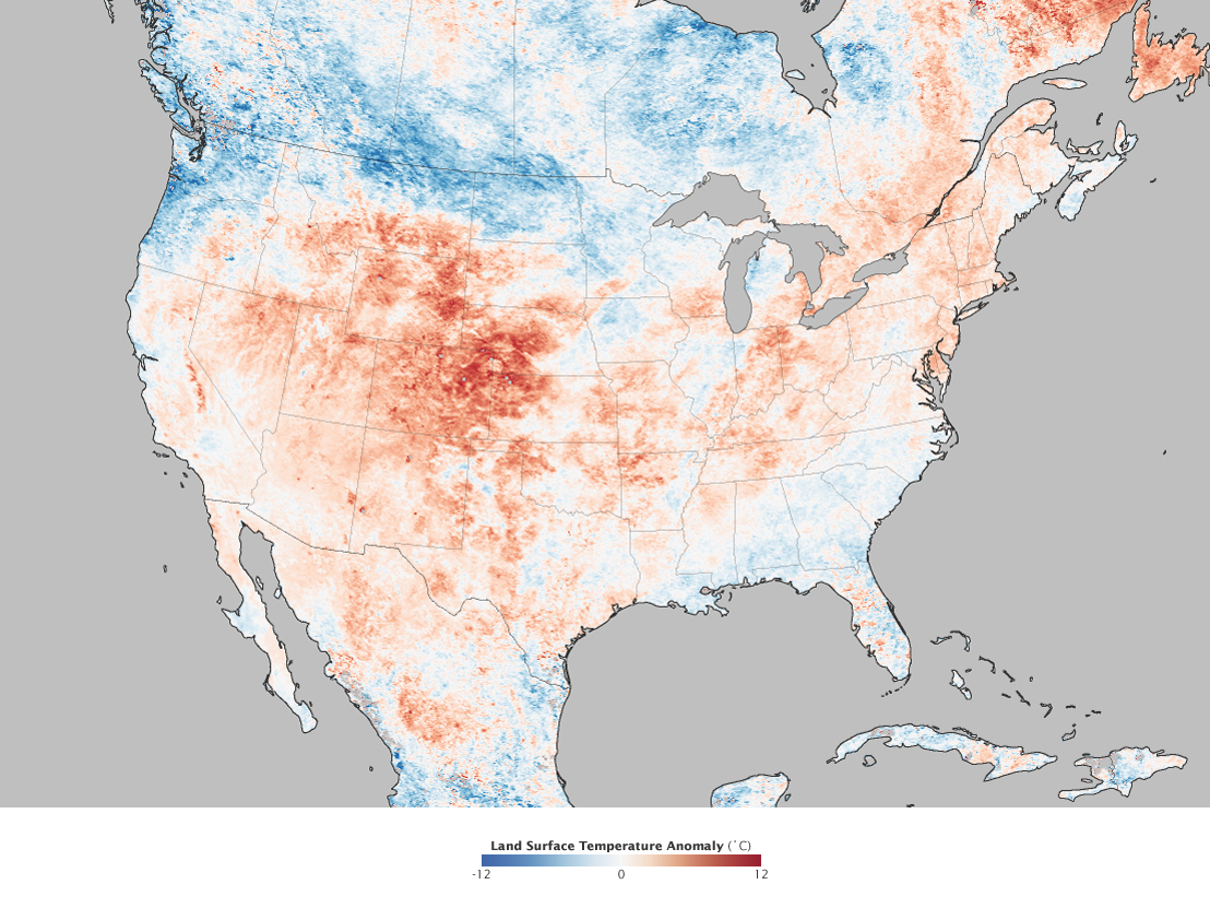
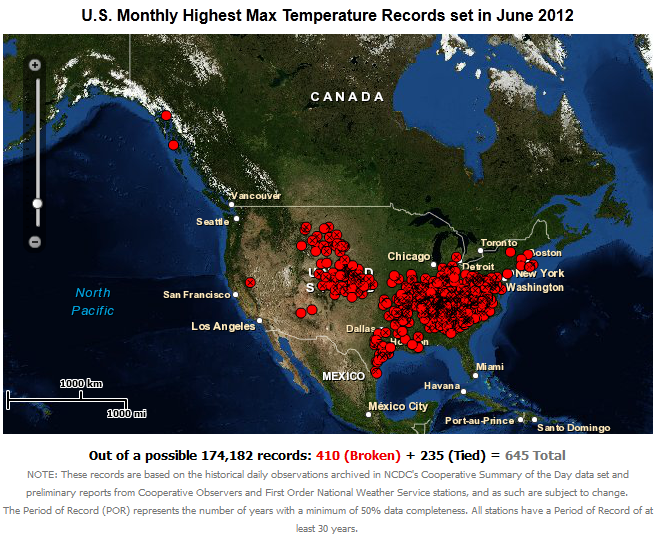
Much of the continental U.S. sweltered under an extreme heat wave throughout June. According to NOAA's NCDC Extremes archive, a total of 645 records were set for all-time hottest June temperatures. Also, 444 new daily maximum temperature records were either set or tied on the single day of June 29th, while 3,282 daily records were broken over the entire month. Unusually high temperatures persisted across the Central Plains near the end of the month. On June 28th, the daily temperature of 47.8°C (118°F) at Norton Dam, Kansas, was the highest in the nation. This extreme broke the location's all-time June record of 45°C (113°F), set just days before on June 25th, and exceeded its previous record of that date (40°C (104°F) on June 28, 1963) by 7.8 degrees Celsius (equivalent to a 14-degree increase in Fahrenheit). Several Midwestern locations saw multiple days of extremes—reminiscent of the country's legendary "Dust Bowl Days" of the 1930s, prompting emergency management officials to issue warnings for excessive heat in nine states. The nation's capital set an all-time June record when the daily maximum temperature reached 40°C (104°F) at the Reagan National Airport on June 29th (previously set at 38.9°C (102°F) in 1874 and again in 2011) making for the hottest day in the District of Columbia area in 142 years.

Torrential rains falling throughout much of June exacerbated existing conditions, and led to evacuations of nearly five million people in China. A flood assistance appeal from ACT Alliance, a humanitarian organization serving in China, attributed the devastation costs suffered from early May through mid-June at $2 billion U.S. dollars and as many as 67 deaths in addition to significant property losses. Relief assistance included rice, oil, and quilts. According to media reports, the city of Yumen (Gansu province) received 69.2 mm (2.72 inches), its highest precipitation on record since 1952 on June 5th, and to its west, more than 500 mm (19.69 inches) of precipitation fell in 24 hours preceding an avalanche near Heicigou that buried 10 members of a mining team. At mid-month, over 123,500 acres of farmland were impacted by flooding and hail damage, and shortages of fresh drinking water for hundreds of thousands of people and livestock were mounting.
Five days of monsoonal deluges in southern Bangladesh as of June 27th, resulted in flash floods and landslides in which at least 91 people were killed, 200 injured, and a quarter million more left stranded. Media reports indicate that road, railroad, and airline travel has been disrupted until the waters recede and hampered rescue operations to remote villages. Rice and fresh water were provided by relief workers.
Wet weather inundated large parts of England and Wales in the first half of June, when over 50 mm (1.97 inches)—more than a month's worth—of precipitation soaked the area in less than 24 hours, during a weekend planned with national celebrations for the Queen's Diamond Jubilee. Swollen rivers closed roadways and dams were breached, prompting evacuations. During the latter half of the month, torrential rains in northern England resulted in flooding when over 100 mm (3.94 inches) of rain fell in 24 hours. Waist-high water inundated numerous homes when local rivers overflowed as residents were rescued by boat. On June 22nd, the intense rain momentarily doused the Olympic Torch during an outdoor procession near Blackpool, as it was being relayed to London for the Games' opening ceremony next month.
In the following days, heavy rains also soaked central and southern Sweden with the central areas receiving three times the monthly normal. As four times the normal precipitation fell (145.8 mm (5.74 inches)) in Stockholm, June became the city's wettest June ever since 1786. Nineteen persons were treated for injuries and seven hospitalized after lightning struck on June 26th at the Peace and Love music festival in Borlange (one of Sweden's largest and most popular venues).
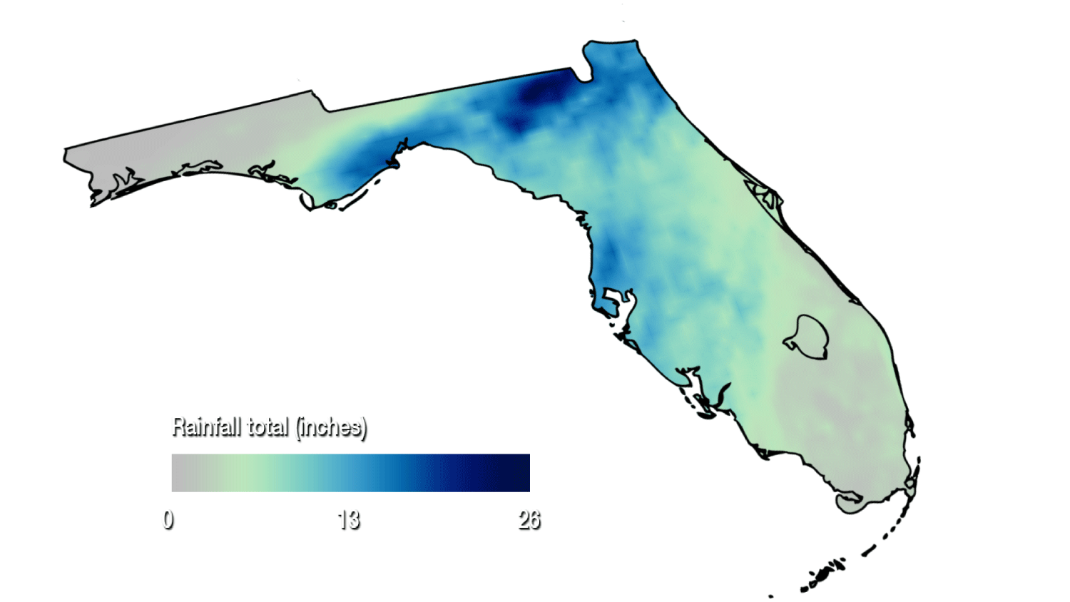
As a harbinger of the massive flooding to be brought by the tropical storm in the coming weeks, U.S. Gulf regions were saturated over June 9th–10th by near record-breaking rainfalls, resulting in damages in excess of $20 million U.S. dollars. Parts of southeastern Alabama and Florida's panhandle were left under 1.5 meters (5 feet) of water after receiving rainfalls nearing 558.8 mm (22 inches). The twenty-hour rainfall of 332.9 mm (13.11 inches) at Pensacola reached close to the city's all-time record of 388.4 mm (15.29 inches) set in 1934. Tornadoes touched down in a couple of locations. Residents were evacuated to Red Cross shelters, roads were closed, power outages were widespread, and one person was killed in a riptide, according to media reports.
In Minnesota, an estimated $100 million U.S. dollars in damages to utilities, roads, bridges, parks and trails as flash floods ravaged the city of Duluth with 184.0 mm (7.25 inches) of precipitation falling over June 19th–20th, breaking the two-day record of nearly 170.2 mm (6.7 inches) set in 1909. Media reports indicated the flooding effects to be the worst seen in 40 years and flood runoff was filling Lake Superior with mud. The U.S. Federal Emergency Management Agency (FEMA) provided assistance to the area. No human lives were lost; however, over a dozen animals at a local zoo drowned.
The first month of winter in Australia brought severe coastal flooding along the New South Wales (NSW) eastern shores during the first week of June, followed by damaging winds, flash floods, and heavy rains to the same region again the next week which marred public events planned in honor of the United Kingdom Queen's Birthday. Major disruption to transportation arose from closure of roads, bridges, and ferry services. Sydney and other coastal regions received some of the heaviest rainfall in months. A total of 73 mm (2.87 inches) of rain fell in 24 hours (June 11th), making it the city's wettest June day in five years.

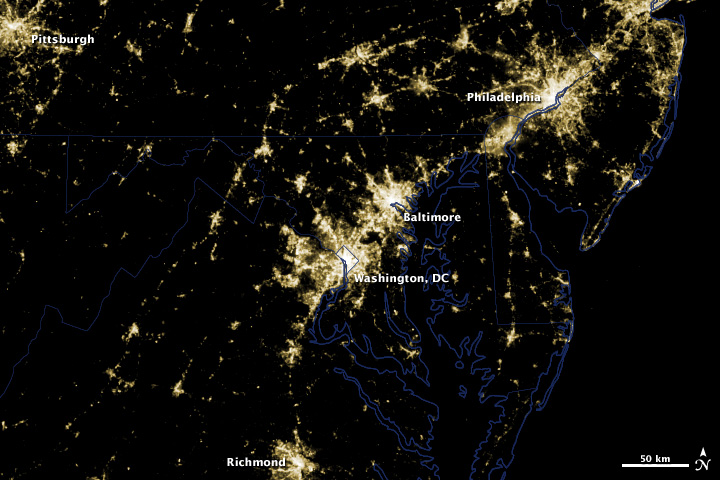
Before Power Outages
Arial view on 28 June 2012
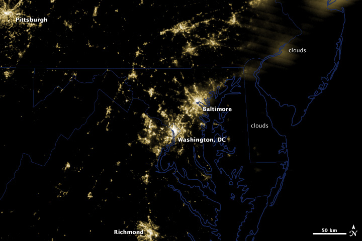
After Power Outages
Arial view on 30 June 2012
Source: NASA Earth Observatory
Hail, wind, and flood damages were estimated at $2 billion U.S. dollars in the wake of two intense thunderstorms sweeping through Dallas, Texas, on June 13th. Media reports depicted the event as the worst in nine years and that three persons were injured inside a flipped mobile home, while multitudes of windshields and rooftops were destroyed by baseball-sized hail stones. Over 6,000 homes and businesses lost power overnight and airline flights were re-routed. A destructive thunderstorm complex (known as a derecho) moved from Illinois to Virginia on June 29th, leaving close to three million homes and businesses without power, and killing at least 18 people. Water restrictions were imposed in Maryland due to damages at water filtration facilities.
Multiple rare appearances of tornadoes occurred within Europe during June. In Sweden, three tornadoes were sighted skirting along its southwestern coast the morning of June 2nd, to the awe of eyewitnesses in a country which typically experiences only 10 tornadoes per year. On June 12th, a destructive tornado struck across Italy's Venice lagoon islands, causing damages to buildings, capsizing boats, and uprooting hundreds of trees. Media reports indicated no deaths occurred, unlike in 1970 when 21 people drowned after being overturned from a watercraft during one of Italy's most deadly tornadoes.
A deadly tornado swept through towns in South Africa's southern tip on June 24th, killing eight residents of Bethlehem and destroying buildings, according to media reports. In Kestel & Eeram, the twister damaged 55 homes, disrupted electricity, and injured nine people. The Red Cross responded with blankets, while members of the local communities provided food.
Heavy thunderstorms, dropping 61 mm (2.40 inches) of rain within six hours, triggered landslides in Africa's mountainous region of Uganda on June 25th in which 18 persons perished. Red Cross officials reported 92 were injured. As deforestation in the area increases, the threat of landslide is more pronounced. In 2010, 87 people were lost in a landslide.

Tropical cyclone activity within the Atlantic continued in June as Hurricane Chris (June 19th–22nd) formed off the U.S. eastern coast and Tropical Storm Debby (June 23rd–27th) formed in the Gulf of Mexico. Having four named storms in the Atlantic before July 1st is a first time occurrence since record-keeping began in 1851, according to NOAA's National Hurricane Center. Analysis of NOAA's NCDC global archive of tropical cyclones (IBTrACS) indicates that August 18th is the average date of the fourth tropical storm forming in the Atlantic Basin (based on 30 years, 1981–2010). Chris, the first hurricane of the 2012 Atlantic season, downgraded within six hours, developed unusually far north and stayed entirely at sea. Whereas, Debby forced evacuations of offshore oil and natural gas production platforms as strong winds and heavy rains stretched from Louisiana to the Florida panhandle. Media reports as of June 29th indicated that seven storm-related deaths in Florida resulted. Precipitation in excess of 508.0 mm (20 inches) fell over the area. Please see NOAA's outlook for 2012 for additional information on hurricane development in the Atlantic, Eastern Pacific, and Central Pacific regions.
Hurricane Carlotta (June 13th–16th) formed in the Eastern Pacific, bringing damaging winds and heavy rains to southern Mexico. Three deaths were attributed to the storm in media accounts, two resulting from a mudslide and one when a moving car was overturned by powerful winds.
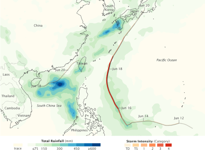
Of eleven Western Pacific tropical cyclones to date in 2012, four matured in June, of which two reached hurricane strength. Typhoon Mawar (also known as Ambo, May 31th–June 6th) and Typhoon Guchol (a.k.a. Butchoy, June 10th–20th) followed similar tracks along the Philippines toward Japan, bringing heavy rains, flash floods and landslides. At times, the rains fell at as much as 25.4 mm per hour (an inch per hour), and two persons died, while dozens were injured, according to local media reports. The more powerful Guchol triggered widescale evacuations, forced cancellation of hundreds of domestic flights and interrupted train services before eventually making landfall in Japan. Originating over the South China Sea, Tropical Storm Talim (a.k.a Carina, June 16th–20th) made a rare passage through the Taiwan Strait. Damages nearing $25 million U.S. dollars resulted to the already waterlogged areas of China and Taiwan, in combined effects of storms and Southwest Monsoon. Tropical Storm Doksuri (a.k.a Dindo, June 25th–30th) spawned east of the Philippines with a projected track toward China. At month's end, a new tropical depression formed briefly east of Palau (June 30th–July 1st).
Tropical Storm Kuena (June 5th–7th) formed in the South-West Indian Ocean to the east of Madagascar during June, making for a bit unusual occurrence as the typical season of tropical cyclones for this area ends on May 15th.

From June 10th–12th, a rare series of cyclonic-like storms battered Western Australia with heavy rain and wind. Extended power outages ensued after high winds downed numerous utility lines across a large area, leaving over 110,000 residents without electricity and at least 10 area hospitals relying on generators, according to media reports. For Perth, the occurrence was depicted as a once in 10-year event (e.g., three major storms to hit in a few days). The initial rains brought some relief for the country's Wheat Belt, where rainfall has been below one-third of normal. A brief tornado damaged about 100 homes near the city, which typically has nine wintertime tornadoes. Another strong cold front brought intense rain on the western coast in the latter half of the month setting a record in Bunbury as the second wettest June on record since 2003.

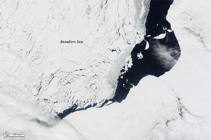
Pre-June Rapid Melting
Arial view on 13 May 2012
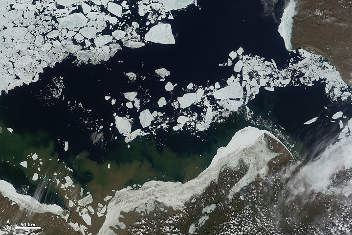
Mid-June Rapid Melting
Arial view on 16 June 2012
Source: NASA Earth Observatory
Sea ice across the entire Arctic reached daily record-low levels for the month of June. Melting in the Beaufort Sea, north of Alaska was notable, in excess of twice the climatological rate, according to recent findings by National Snow and Ice Data Center (NSIDC). Clear skies and above freezing temperatures resulted in favorable conditions for snow to melt and the land to warm.

Cacti and desert trees have begun to show signs of stress due to the prolonged drought in the southwest U.S., according to media reports. Plants at the Arizona-Sonora Desert Museum were observed to be withering from the extreme lack of moisture.
 NOAA's National Centers for Environmental Information
