Updated 14 June 2012

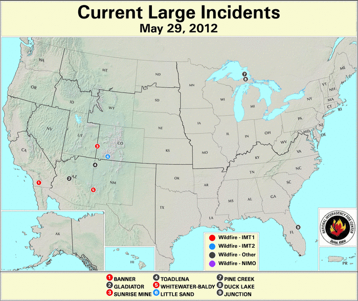
A massive wildfire, triggered on May 26th by two lightning strikes, destroyed a dozen cabins and 7 small outbuildings in southwestern New Mexico and spread smoke across the state and into Arizona, prompting air-quality warnings. The wildfire, which grew due to the persistent winds, scorched nearly 85,000 acres. More than 500 firefighters battled the blaze. In southern California, a wildfire that burned through 3,100 acres from May 24th–26th prompted the evacuation of 100 homes in the Shelter Valley area and an additional 50 people from a recreational vehicle park in San Diego County. Across Nevada, a permitted burn in the Topaz Ranch Estates was rekindled by the gusty winds, spreading quickly and destroying two homes and 17 outbuildings, and scorching 7,500 acres. Please visit the U.S. Wildfires page for additional information on wildfires.
Severe drought gripped northeastern Brazil during May, the worst drought there in five decades, affecting over 1,100 towns. According to reports, the severe drought caused what is called "water wars" in rural areas, with an average of one person a day being killed in these "water wars". The water shortages have endangered the lives of local people and their livestock.

Flash floods on May 2nd impacted Ethiopia's Somali region, causing significant damage. The flash floods damaged planted crops and stored foods in the affected areas, and claimed the lives of numerous livestock.
A low pressure system brought copious rain to northern parts of Honduras, prompting floods that caused damage to 106 homes and forced the evacuation of 500 people in the Trojes, El Paraíso municipality. Fortunately, no fatalities were reported.
Torrential rain fell across central Cuba during the week of May 18th, claiming the lives of two people, damaging or destroying nearly 1,200 homes, and forcing the evacuation of thousands of residents. According to media reports, the province of Sancti Spiritus (east of Havana) is the most affected area, with rivers and dams reaching their 98% capacity and over 8,500 people affected. More than 8,100 acres of crops were flooded, with the most important damages occurring to sugar cane fields, tobacco, and coffee.

Severe storms produced heavy downpours and dangerous hail across parts of northwestern China on May 10th. The storms were responsible for 40 fatalities and leaving 87 people with injuries and an additional 18 people missing. The storms affected more than two-thirds of the Gansu province's 450,000 residents. According to reports, homes collapsed, roads were blocked, farmlands were destroyed, and the power supply services were disrupted.

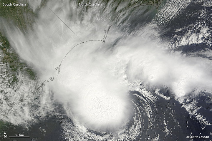
Tropical Storm Alberto formed off the coast of South Carolina and Georgia, U.S. on May 19th. Alberto was the first named Atlantic storm in the 2012 Atlantic hurricane season and the first storm to form during May—the month prior to the official start of the hurricane season—in the Atlantic basin since Tropical Storm Arthur (May 31st–June 2nd) in 2008. Alberto is also the earliest-forming tropical storm in the Atlantic basin since Tropical Storm Ana (April 20th–24th) in 2003. Although the official Atlantic hurricane season begins on June 1st, there have been a total of 18 tropical storms to have formed in May since records began in 1851. However, Alberto is one of three Atlantic tropical storms to have formed in May in over three decades. Although Alberto did not make landfall, it caused disruptions to the tourist industry as tourist cruises were cancelled. The tropical storm also prompted thunderstorms across parts of the region. Alberto dissipated on May 22nd. The East North Pacific Basin also saw its first tropical storm in the 2012 Hurricane Season, when Tropical Storm Aletta formed on May 14th. Aletta was not a threat to any land areas and did not make landfall. Aletta dissipated on May 19th. This was also the first time a tropical storm formed before the official start of the hurricane season in both the Atlantic and East Pacific basins. The official East North Pacific hurricane season begins May 15th.
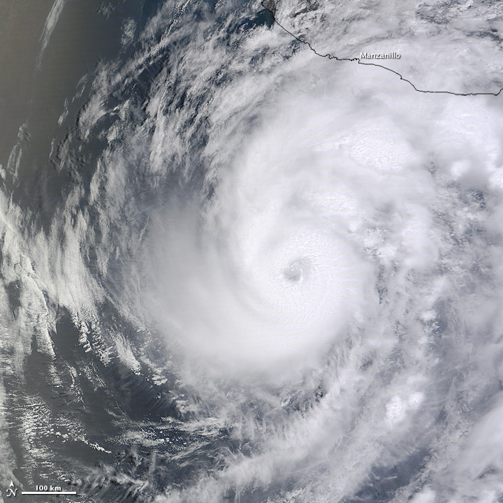
On May 21st, the East North Pacific recorded its second tropical storm to form during the 2012 Hurricane season. Hurricane Bud developed south of Mexico and quickly intensified to hurricane status by May 24th. The storm reached its peak intensity on May 25th, with maximum sustained winds of 115 mph (185 km/hr) which is a Category 3 hurricane. Hurricane Bud tracked towards the Mexican coast, prompting the government to prepare for the storm by closing in Colima and Jalisco Mexican states, closing the port of Manzanillo, banning swimming in the ocean in Puerto Vallarta, and opening nearly 1,000 shelters in Guerrero and Colima. The storm produced heavy downpours and waves of six feet, and strong winds knocked trees down. Bud dissipated rapidly offshore on May 26th. According to reports, Bud was the strongest East North Pacific storm on record to form so early in the year and ties with 2002 Hurricane Alma as the strongest May hurricane on record in the East North Pacific Basin, behind 2001 Hurricane Adolph.
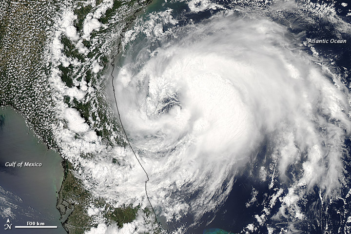
The second tropical storm to have formed in the 2012 Atlantic Hurricane season was Tropical Storm Beryl. Beryl formed on May 26th off the coast of South Carolina as a subtropical storm. However, by the next day the storm transitioned into a tropical cyclone. On May 27th, Beryl made landfall in northeastern Florida near Jacksonville Beach with maximum sustained winds of 70 mph (110 km/hr). Beryl became the strongest landfalling May storm since the May 1908 hurricane which had maximum sustained winds of 75 mph (120 km/hr). Beryl was also the second storm to make landfall during Memorial Day weekend in the U.S., behind the Subtropical Storm Alpha in 1972. Although Beryl ruined people's three-day vacation plans, the storm brought much-needed rain to the drought-stricken areas in the southeastern United States. Beryl also produced strong winds, causing trees to fall and downing power lines, leaving nearly 23,000 customers without electricity across northern Florida and parts of Georgia. Minor flooding was also reported in some affected areas.
 NOAA's National Centers for Environmental Information


