
Global Highlights
- The year 2013 ties with 2003 as the fourth warmest year globally since records began in 1880. The annual global combined land and ocean surface temperature was 0.62°C (1.12°F) above the 20th century average of 13.9°C (57.0°F). This marks the 37th consecutive year (since 1976) that the yearly global temperature was above average. Currently, the warmest year on record is 2010, which was 0.66°C (1.19°F) above average. Including 2013, 9 of the 10 warmest years in the 134-year period of record have occurred in the 21st century. Only one year during the 20th century—1998—was warmer than 2013.
- Separately, the 2013 global average land surface temperature was 0.99°C (1.78°F) above the 20th century average of 8.5°C (47.3°F), the fourth highest annual value on record.
- The 2013 global average ocean temperature was 0.48°C (0.86°F) above the 20th century average of 16.1°C (60.9°F) and tied with 2006 as the eighth highest annual temperature on record and the highest since 2010, the last time El Niño conditions were present in the central and eastern equatorial Pacific Ocean. ENSO-neutral conditions were present in this region during all of 2013.
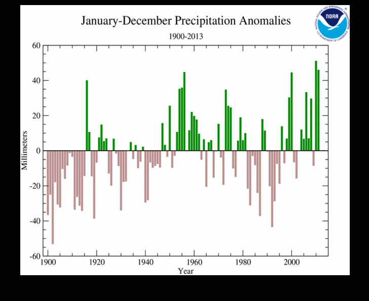
- Precipitation measured at land-based stations around the globe was near average on balance for 2013, at just 0.31 mm above the long-term average. However, as is typical, precipitation varied greatly from region to region. This is the second consecutive year with near-average global precipitation at land-based stations.
Global Temperatures
The year 2013 tied with 2003 as the fourth warmest year globally since records began in 1880. The annually-averaged temperature across global land and ocean surfaces was 0.62°C (1.12°F) above the 20th century average and marks the 37th consecutive year (since 1976) that the annual temperature was above the long-term average. Currently, the warmest year on record is 2010, which was 0.66°C (1.19°F) above average. To date, including 2013, 9 of the 10 warmest years on record have occured during the 21st century. Only one year during the 20th century—1998—was warmer than 2013. The global annual temperature has increased at an average rate of 0.06°C (0.11°F) per decade since 1880 and at an average rate of 0.16°C (0.28°F) per decade since 1970.
Top 10 Warmest Years (1880–2013)
The following table lists the global combined land and ocean annually-averaged temperature rank and anomaly for each of the 10 warmest years on record.
| Rank 1 = Warmest Period of Record: 1880–2013 |
Year | Anomaly °C | Anomaly °F |
|---|---|---|---|
| 1 | 2010 | 0.66 | 1.19 |
| 2 | 2005 | 0.65 | 1.17 |
| 3 | 1998 | 0.63 | 1.13 |
| 4 (tie)* | 2013 | 0.62 | 1.12 |
| 4 (tie)* | 2003 | 0.62 | 1.12 |
| 6 | 2002 | 0.61 | 1.10 |
| 7 | 2006 | 0.60 | 1.08 |
| 8 (tie)* | 2009 | 0.59 | 1.07 |
| 8 (tie)* | 2007 | 0.59 | 1.06 |
| 10 (tie) | 2004 | 0.57 | 1.04 |
| 10 (tie) | 2012 | 0.57 | 1.03 |
Separately, the average global land temperature was 0.99°C (1.78°F) above the 20th century average and ranked as the fourth highest annually-averaged value on record. Because land surfaces generally have low heat capacity, temperature anomalies can vary greatly between months. Over the course of 2013, the average monthly land temperature anomaly ranged from +0.71°C (+1.28°F; April, August) to +1.43°C (+2.57°F; November), a difference of 0.72°C (1.29°F). The ocean has a much higher heat capacity than land and thus anomalies tend to vary less over monthly timescales. During the year, the global monthly ocean temperature anomaly ranged from +0.40°C (+0.72°F; January) to +0.56°C (+1.01°F; September), a difference of 0.16°C (0.29°F).
For the period January–December, continual ENSO-neutral conditions contributed to a globally-averaged ocean surface temperature departure of 0.48°C (0.86°F) above the 20th century average, tying with 2006 as the eighth warmest year on record. This is 0.04°C (0.07°F) below the record high annually-averaged ocean temperature of 0.58°C (1.04°F), which was observed in both 1998 and 2003.
| January–December | Anomaly | Rank (out of 134 years) | Records | ||||
|---|---|---|---|---|---|---|---|
| °C | °F | Year(s) | °C | °F | |||
| Global | |||||||
| Land | +0.99 ± 0.19 | +1.78 ± 0.34 | Warmest | 4th | 2007 | +1.09 | +1.96 |
| Coolest | 131st | 1884 | -0.59 | -1.06 | |||
| Ocean | +0.48 ± 0.03 | +0.86 ± 0.05 | Warmest | 8th | 1998, 2003 | +0.52 | +0.94 |
| Coolest | 127th | 1909, 1910 | -0.45 | -0.81 | |||
| Ties: 2006 | |||||||
| Land and Ocean | +0.62 ± 0.09 | +1.12 ± 0.16 | Warmest | 4th | 2010 | +0.66 | +1.19 |
| Coolest | 131st | 1909, 1911 | -0.43 | -0.77 | |||
| Ties: 2003 | |||||||
| Northern Hemisphere | |||||||
| Land | +1.02 ± 0.25 | +1.84 ± 0.45 | Warmest | 4th | 2007 | +1.22 | +2.20 |
| Coolest | 131st | 1884 | -0.70 | -1.26 | |||
| Ocean | +0.51 ± 0.05 | +0.92 ± 0.09 | Warmest | 5th | 2005 | +0.55 | +0.99 |
| Coolest | 130th | 1910 | -0.47 | -0.85 | |||
| Land and Ocean | +0.71 ± 0.14 | +1.28 ± 0.25 | Warmest | 4th | 2010 | +0.77 | +1.39 |
| Coolest | 131st | 1912 | -0.46 | -0.83 | |||
| Southern Hemisphere | |||||||
| Land | +0.89 ± 0.11 | +1.60 ± 0.20 | Warmest | 3rd | 2005, 2009 | +0.91 | +1.64 |
| Coolest | 132nd | 1917 | -0.62 | -1.12 | |||
| Ocean | +0.47 ± 0.03 | +0.85 ± 0.05 | Warmest | 9th | 1998 | +0.54 | +0.97 |
| Coolest | 126th | 1911 | -0.46 | -0.83 | |||
| Ties: 2004, 2005 | |||||||
| Land and Ocean | +0.54 ± 0.06 | +0.97 ± 0.11 | Warmest | 6th | 1998 | +0.59 | +1.06 |
| Coolest | 129th | 1911 | -0.46 | -0.83 | |||
| Ties: 2005 | |||||||
| Arctic | |||||||
| Land and Ocean | +0.91 ± 0.12 | +1.64 ± 0.22 | Warmest | 11th | 2007 | +1.42 | +2.56 |
| Coolest | 124th | 1902 | -1.28 | -2.30 | |||
The 1901-2000 average combined land and ocean annual temperature is 13.9°C (56.9°F), the annually averaged land temperature for the same period is 8.5°C (47.3°F), and the long-term annually averaged sea surface temperature is 16.1°C (60.9°F).
Regional Temperatures
The following information was compiled from previous NCDC monitoring reports, public reports by National Hydrometeorological Services (NHMSs; peers of the U.S. National Weather Service), including those submitted to inform the Provisional Status of the Climate in 2013 by the World Meteorological Organization. More comprehensive information will be available in the WMO's final Statement, to be released in Spring 2014.
Most areas of the world experienced above-average annual temperatures, as indicated by the Temperature Percentiles map below. Over land, parts of central Asia, western Ethiopia, eastern Tanzania, and much of southern and western Australia were record warm, as were sections of the Arctic Ocean, a large swath of the southwestern Pacific Ocean along with parts of the central Pacific, and an area of the central Indian Ocean. Only part of the central United States was cooler than average over land. Small regions scattered across the eastern Pacific Ocean and an area in the Southern Ocean south of South America were cooler than average. No region of the globe was record cold during 2013.
The Arctic Oscillation was a major driver of weather patterns during early 2013 across the Northern Hemisphere. Cooler-than-average spring temperatures were present across much of Europe, the southeastern United States, northwestern Russia, and parts of Japan, while in contrast the Arctic region was considerably warmer than average, along with much of central and northern Africa, the eastern Mediterranean, southern Russia, and much of China. This pattern is characteristic of the negative phase of the Arctic Oscillation, which had several exceptionally negative values during the first half of spring. During March 2013, the most negative Arctic Oscillation index value for this month and the most negative since the record value of February 2010 was recorded.
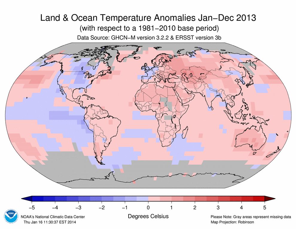

Temperatures across most of North America were above average during 2013, but overall more moderate than 2012, which brought record heat to much of the continent. It was warmer than average during winter for both Canada and the United States. However, the contiguous United States observed its coolest spring since 1996 and first cooler-than-average season overall since winter 2010/11. Canada was warmer than average for the spring, and summer was the eighth warmest on record. Alaska observed its second warmest summer on record and ended the year with the last three months (October–December) being the state's sixth warmest such period on record. It was a record warm summer for Mexico, with July and August both record warm; the warmth continued into fall for the country, with September sixth warmest for the month and October third warmest.
In South America, a warm October–December period contributed to Argentina's second warmest year since records began in 1961, at 0.57°C / 1.03°F above average, behind only the record warmth set just last year in 2012. Many regions of the country had their warmest December on record, due largely to the most significant heat wave in Argentina since February 1987. December 2013 was the warmest of any month for the captial city of Buenos Aires since records began in 1906. Argentina's five warmest years on record have all occurred in the past eight years (since 2006).
Across the African continent, Kenya observed above-average maximum temperatures during January, February, and August. Several daily maximum records were broken for these months at various locations, including Wajir, Mombasa, Mandera, and Dagoretti Corner (Nairobi). The average January temperature at Wajir was the highest recorded in the past half century. In West Africa, the temperature in Navrongo, Ghana reached 43.0°C (109.4°F) on March 6th, the warmest temperature ever measured in Ghana for any month. A summer temperature that was 2.2°C (4.0°F) above average contributed to one of the 10 warmest January–August periods in Tunisia since 1950.
Many regions across Europe were warmer than average at the start of 2013. Reykjavik, Iceland recorded its warmest January since 1987 and the north east of the country had its warmest January–February on record. However, spring brought extremely cold conditions affecting a large swath of Europe. In most of European Russia, March was colder than February for the first time since 1957. In the north of this region, it was the coldest March in the past half century, as temperatures were 8°–10°C (14°–18°F) below average in some areas. France had its coolest spring since 1986 and the Netherlands recorded its coolest spring in more than 40 years. Spring brought the United Kingdom its coolest March since 1962 and the coolest month of any month since December 2010, along with the coolest April and May since 1989 and 1996, respectively.
In contrast, along the western Greenland coast, Pituffik/Thule Air Force Base experienced its all-time warmest March, and Norway and Sweden each recorded one of their five warmest Mays in more than a century. Warmer-than-average spring conditions were enjoyed in southern and eastern parts of Europe. Croatia, Montenegro, Hungary, Moldova, and Latvia had higher-than-average temperatures in April and May. Spring temperatures were also above average for a large part of Russia; April was among the 10 warmest such periods for the country since records began in 1891. Central and southern European Russia observed its second warmest May on record.
Summer was much warmer than average over many European countries, as the United Kingdom and Spain had their third and fifth warmest Julys on record, respectively. Austria had its second warmest July, tied with 1983 and behind 2006, since records began in 1767. On August 8th, Austria set a new national record high temperature of 40.5°C (104.9°F) in lower German-Altenburg. This was the first date a temperature above 40°C (104°F) was ever measured in Austria. It was also one of the 10 warmest summers for Montenegro.
The beginning of fall was also anomalously warm over Europe, as Norway, Finland, and Spain all reported above-average temperatures for September. In north-east Greenland, Danmarkshavn and Daneborg were record warm for the month. Spain had its sixth warmest October on record, while it was Austria's warmest since 2006.
Northern East Asia had a cold period during its 2012/13 winter season, associated with negative Arctic Oscillation conditions and blocking patterns around eastern Siberia. During this period, most of Siberia was 2°–3°C (4°–5°F) below average, making this one of the coldest winters for the region in the 21st century. Record-low temperatures were recorded in Siberia, Yakutia, Kolyma, and Chukotka, as well as the Arctic coast. South Korea observed its fourth coldest April since records began in 1973.
In other regions of Asia, Thailand had a February monthly temperature more than 1°C (2°F) above average. Hong Kong observed its fourth warmest February on record; during March and April many daily maximum temperature records were broken, with some locations exceeding 40°C (104°F). March temperatures were 2°–4°C (4°–7°F) above average in most of China, and 4°–6°C (7°–11°F) above normal in central and northwestern parts of the country. In the pre-monsoon month of May, Pakistan saw its most severe heat wave in decades. The temperature reached 51°C (124°F) at Lakarna, southern Sindh province, on May 19th,, the highest May temperature in that city since 1998.
Summer was much warmer than average across many parts of Asia. The northwestern Pacific High and the Tibetan High were enhanced during July and August, contributing to Japan's hottest summer on record. On August 12th, Ekawasaki station in Shimanto-city, Kochi Prefecture recorded a temperature of 41.0°C (105.8°F), the highest temperature ever observed in Japan. A persistent heat wave was present from the beginning of July to the end of August across most of southern China. It was one of the most severe on record with respect to its geographical extent, duration, and intensity; more than 300 stations exceeded a daily maximum temperature of 40°C (104°F) during the period. The heat wave contributed to China observing its warmest August on record (tied with 2006). South Korea observed its fourth warmest July and warmest August, both of which contributed to a record-warm summer.
Extreme warmth settled over Russia towards the end of 2013. Following its record warmest November of 5.3°C (9.5°F) above the 1961–1990 average, the country as a whole observed its record warmest December, at 4.6°C (8.3°F) higher than average. Moscow and St. Petersburg broke their daily maximum temperature records on December 25th by 0.4°C (0.7°F) and an impressive 1.4°C (2.5°F), respectively.
In the South-west Pacific, Australia started off the year with extreme heat, with January 2013 the hottest month ever observed in the country. Monthly maximum temperature anomalies reached +5°C (+9°F) in north west New South Wales. Widespread heat across the continent contributed to this record, as opposed to extreme heat at individual locations. On January 7th, a new national area-averaged daily maximum temperature of 40.30°C (104.54°F) was set. The extreme warmth combined with a warmer-than-average December and February to give the country its hottest summer (December–February) on record. Warmer-than-average temperatures continued through the year as Australia observed its third warmest winter (June–August) on record followed by its record warmest spring (September–November). Temperatures for September were 2.75°C (4.95°F) above average, the highest monthly temperature departure from average ever recorded in Australia. The country recorded its all-time warmest 12-month period during September 2012–August 2013, only to see the record broken the following two consecutive months, making November 2012–October 2013 the current warmest 12-month period on record. The anomalous warmth was also present during austral winter in New Zealand, which experienced its fourth warmest July and record warmest August. These warm months contributed to the country's warmest winter on record.
In summary for 2013 as a whole, most regions across the globe were warmer than average. Notably, Australia observed its warmest year since national records began in 1910, at 1.20°C (2.16°F) above average and 0.17°C (0.31°F) higher than the previous record warmest such period in 2005. New Zealand recorded its third warmest year since its national records began in 1909. Argentina had its second warmest year since records began in 1961, behind only the record extreme warmth of 2012. In northern Europe, Finland tied as the fifth warmest year on record, at 2.0°C (3.6°F) above the 1961–1990 average. In southern Europe, the 2013 annually-averaged temperature for Spain was above average, but was the coolest year since 1997. Switzerland observed an annual temperature 0.8°C (1.4°F) above the 1961–1990 average, the coolest year since 2010. Belarus had an annual temperature 1.6°C (2.9°F) higher than the 1961–1990 average, the ninth warmest for the country since national records began in 1881. With a record warm end to the year, Russia observed its sixth warmest year since records began in 1891.
Global Precipitation
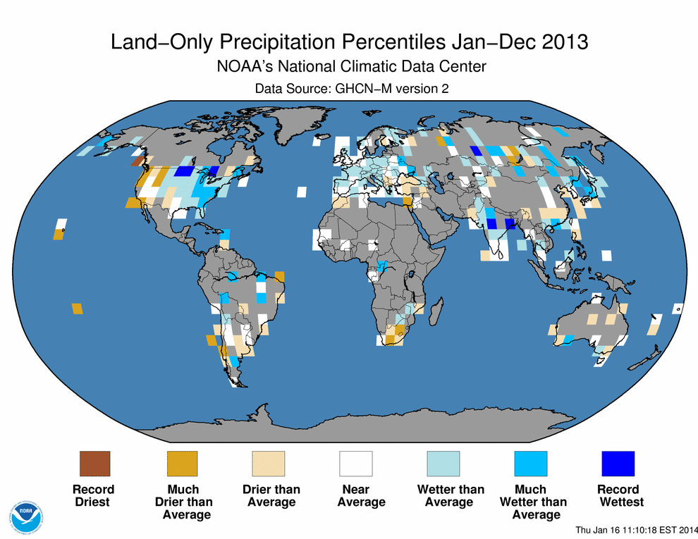
For the second consecutive year, annual precipitation was near average on balance for land-based rain gauges around the globe. Precipitation for 2013 was just 0.31 mm (0.01 inch) above the 1961–1990 average of 1,033 mm (40.7 inches). As indicated by the Global Precipitation Percentiles map below, central Russia, parts of central and eastern India, the north central United States, and a section of southern Canada were record wet for the year, while a region of coastal western Canada was record dry, as indicated by the precipitation percentiles map below. Also, as discussed below, extreme precipitation and drought events occurred across the world.
In January, a tropical low caused major flooding along much of the east coast of Queensland and northern New South Wales in Australia. The Burnett River catchment had the most severe flooding, receiving nearly 70 percent rainfall above the previous record. Bundaberg had its highest flood on record, with many residential areas inundated. In northern New South Wales, the Clarence River at Grafton also reached record flood height.
Israel, Lebanon, and Jordan received rare snowfall on January 10th. Up to 20 cm (8 inches) of snow fell in Jerusalem, marking the biggest snowstorm in this area since 1992.
For the second consecutive year, northeastern Brazil experienced severe drought conditions. This follows the decade of 2001–2010, when large parts of the Amazon Basin saw prolonged drought. This year's drought is considered to be the worst in the past 50 years. The Brazilian Plateau, the core monsoon region in South America, experienced its largest rainfall deficit since records began in 1979.
Drier-than-normal weather conditions since late 2012 resulted in severe drought conditions in the northern Republic of Marshall Islands and led to critical shortages of safe drinking water and damages to food crops. On May 6th 2013, the Republic of Marshall Islands Cabinet declared a state of disaster for the drought.
With little significant rainfall in northern and eastern parts of New Zealand since October 2012, by early 2013 the country was suffering its worst drought in decades. A drought zone was declared over the entire North Island and parts of the South Island. Measures of soil moisture deficit were at their highest levels since the 1970s and parts of the North Island were the driest in the past 70 years, receiving between a third and a half of average rainfall levels during the summer.
Following its biggest snowfall event in the past 50 years in November 2012, by early February, Moscow, Russia had already recorded its heaviest winter snowfall accumulation in more than a century, with 216 cm (85 inches) of snow compared to the average of 152 cm (60 inches). March brought an additional 71 cm (28 inches), the highest total for the month in more than 20 years.
During March 22nd–24th, at least 20 cm (8 inches) of snow fell widely across northern parts of the United Kingdom, especially across higher elevations, with blizzard conditions and significant drifting. This was the region's most significant late winter snow event since 1979 and snow remained on the ground until early April.
On April 2nd, the city of La Plata, Argentina, received about 300 mm (11.8 inches) of rainfall in three hours. The torrential downpour led to flash flooding that resulted in more than 50 fatalities. It is one of the worst weather disasters in Argentina's history.
Following nearly three decades of low seasonal rainfall and a second consecutive year of failed rains, in much of 2013, the southern African countries of Angola and Namibia were gripped by one of the worst droughts in the past 30 years. And while these areas suffered drought conditions, floods hit various other regions across Africa during the year. Mozambique experienced severe flooding during January 12th–31st, while heavy rainfall during March–April led to flooding that damaged crops and displaced thousands of people throughout parts of southern Somalia and eastern Kenya. On August 28th, torrential rains led to flash floods in Bamako, Mali in West Africa. At least 37 people were killed when the Niger River overflowed its banks.
During July and August, southern China experienced severe drought conditions. Zhejiang, Jiangxi, Anhui, Hunan, Hubei, Guizhou, and Chongqing provinces received about 135 mm (5.3 inches) of rainfall during July 1st–August 21st, just 48 percent of average precipitation. An estimated 78 million people were impacted and more than 8 million hectares (19.8 million acres) of farm lands were affected. Direct economic losses are estimated to be about $7.7 billion US dollars.
Extreme precipitation in Europe's Alpine region and in Germany, Poland, Czech Republic, Austria, and Switzerland caused the most intense and extended flooding in Danube and Elbe river catchments since at least 1950 as more than 400 mm (15.7 inches) of rain fell in some localized areas on May 29th–June 3rd, an event with a return period of more than 100 years. Austria observed its wettest May–June since national records began in 1858. Some rivers reached historical record heights. Passau/SE-Germany saw its highest water level since 1501. Twenty-five people were killed in Germany, Austria, and the Czech Republic as a result of the floods.
The Southwest Asian monsoon season had an early onset of June 16th and brought the worst flooding and devastation in the past half century to regions near the India-Nepal border. Twenty districts in Nepal and several districts in the Indian states of Uttarakhand, Himachal Pradesh, and Uttar Pradesh were affected. The monsoon arrived 15 days early in Uttarakhand, with constant rain over a four-day period. Northwest India received nearly double its average June rainfall. Thousands of people were killed.
In north east Asia, from the end of July to mid-August 2013, unusually heavy rain fell near the Amur River, which marks the border between China and Russia. The river reached a record 100.56 m (329.9 feet), surpassing the previous record set in 1984, as heavy flooding hit parts of the region. The Songhuajiang and Liaohe River Basins in northeast China saw their heaviest floods since 1998. Nankouqian Township measured 449 mm (17.7 inches) of rain — half its average annual total — in a single day on August 16th. Heavy flooding was also reported in eastern Russia, where more than 140 towns were affected by their worst flooding in 120 years. In China there were direct economic losses of about $1.8 billion US dollars and more than 100 fatalities. In the Amur region of Russia, economic losses were estimated at $500 million US dollars.
In the United States during September 9th–16th, a cut-off low pressure system situated over the Great Basin pumped deep tropical moisture into the Colorado Front Range, resulting in record-breaking precipitation. In Boulder, Colorado 231 mm (9.1 inches) of rain fell on September 12th, setting a new 24-hour precipitation record for the city. Boulder also broke its monthly and annual precipitation records due to the event. Streams and rivers approached and exceeded record levels with widespread flooding reported. Wildfires earlier in the summer left much of the land charred, contributing to the massive runoff.
For the first time since 1958, two tropical cyclones from two separate basins (Ingrid in the North Atlantic and Manuel in the Eastern North Pacific) struck Mexico nearly simultaneously on September 15th. Large amounts of rain combined with orographical precipitation enhancement over Mexico's mountainous regions led to major flooding and landslides. In total, 24 of Mexico's 31 states were impacted by the storms. Heavy rain temporarily isolated the resort town of Acapulco.
References
- Peterson, T.C. and R.S. Vose, 1997: An Overview of the Global Historical Climatology Network Database. Bull. Amer. Meteorol. Soc., 78, 2837-2849.
- Quayle, R.G., T.C. Peterson, A.N. Basist, and C. S. Godfrey, 1999: An operational near-real-time global temperature index. Geophys. Res. Lett., 26, 333-335.
- Smith, T.M., and R.W. Reynolds (2005), A global merged land air and sea surface temperature reconstruction based on historical observations (1880-1997), J. Clim., 18, 2021-2036.
- Smith, et al (2008), Improvements to NOAA's Historical Merged Land-Ocean Surface Temperature Analysis (1880-2006), J. Climate., 21, 2283-2293.