Sea Ice Extent
| September 2014 | Sea Ice Extent | Anomaly 1991-2020 | Trend per decade | Rank (36 years) | Record | ||||
|---|---|---|---|---|---|---|---|---|---|
| million km² | million mi² | Year(s) | million km² | million mi² | |||||
| Northern Hemisphere | 5.22 | 2.02 | -6.45% | -14.52% | Largest | 30th | 1980 | 7.67 | 2.96 |
| Smallest | 7th | 2012 | 3.57 | 1.38 | |||||
| Southern Hemisphere | 19.76 | 7.63 | +6.18% | +1.18% | Largest | 1st | 2014 | 19.76 | 7.63 |
| Smallest | 36th | 1986 | 17.68 | 6.83 | |||||
| Globe | 24.98 | 9.64 | +3.22% | -2.44% | Largest | 17th | 1980 | 26.49 | 10.23 |
| Smallest | 20th | 2012 | 22.78 | 8.80 | |||||
| Ties: 1984 | |||||||||
Data Source: National Snow and Ice Data Center (NSIDC). Period of record: 1979–2014 (36 years)
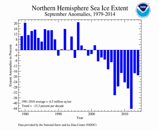
According to the National Snow and Ice Data Center (NSIDC), the Northern Hemisphere (Arctic) sea ice extent — which is measured from passive microwave instruments onboard NOAA satellites — averaged for September 2014 was 5.28 million square km (2.04 million square miles), 1.24 million square km (480,000 square miles), or 19.02 percent, below the 1981-2010 average. This was the sixth smallest September Arctic sea ice extent in the satellite record. According to the NSIDC, sea ice extent was below average in nearly all regions of the Arctic, with the exception of the Barents Sea and part of the seas around the Canadian Archipelago, where the Northwest Passage continued to be choked off. The Northwest Passage has been ice free only four times in recent history — 2007, 2008, 2010, and 2011. In the Laptev Sea, Arctic sea ice extent was much below average, with the ice edge reaching within 5 degrees latitude of the North Pole. The Northern Sea Route was ice free during all of September. Overall, September Arctic sea ice extent is decreasing at an average rate of 12.88 percent per decade.
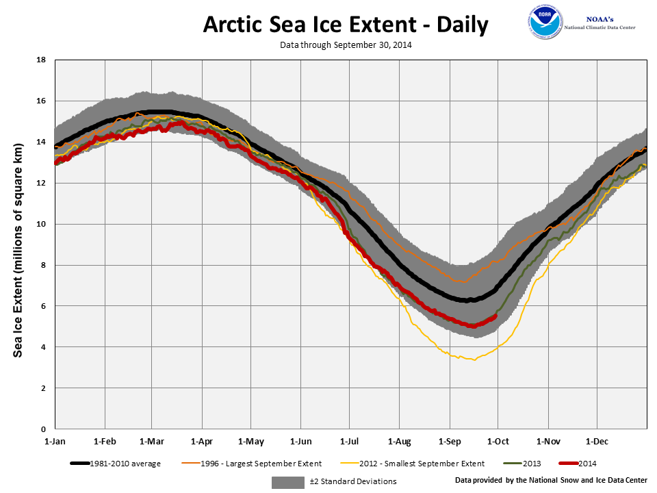
On September 17th, the Artic sea ice extent reached its annual minimum, two days later than average. The 2014 minimum was 5.02 million square km (1.94 million square miles), 1.20 million square km (463,000 square miles) below the 1981-2010 average, but 1.61 million square km (622,000 square miles) larger than the smallest annual minimum extent that occurred in 2012. The 2014 minimum extent was the sixth smallest in the satellite record. From the annual maximum extent that occurred on March 21st to the minimum extent, the Arctic lost a total of 9.89 million square km (3.82 million square miles) of ice, which was the ninth largest amount on record, but the lowest amount of seasonal ice loss since 2006. The 2014 ice loss was 1.92 million square km (741,000 square miles) less than the record ice loss that occurred in 2012.
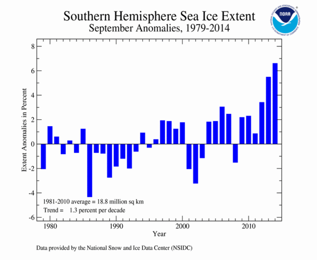
The September 2014 Southern Hemisphere (Antarctic) sea ice extent was 20.03 million square km (7.73 million square miles), 1.24 million square km (480,000 square miles), or 6.60 percent, above the 1981-2010 average. This was the largest September Antarctic sea ice extent on record, surpassing the previous record set just last year by 210,000 square km (80,000 square miles). This also marked the 21st consecutive month with much above-average sea ice extent in the Southern Hemisphere and the sixth consecutive month with record large sea ice. This was also the largest sea ice extent for any month since records began in 1979 and the first time any month had a monthly sea ice extent larger than 20 million square km. Ice extent was above average in nearly all sectors of the Antarctic, particularly notable in the northern Ross Sea and the Indian Ocean. Southern Hemisphere sea ice extent during September is increasing at an average rate of 1.22 percent per decade.
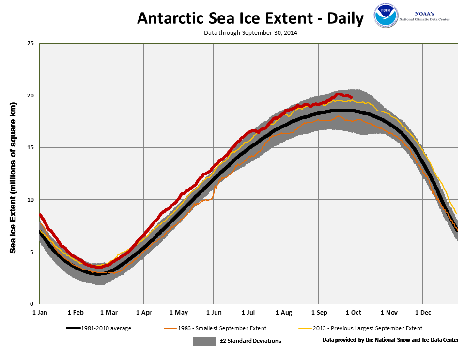
On September 22nd, Antarctic sea ice reached its annual maximum extent at 20.11 million square km (7.76 million square miles), 1.54 million square km (595,000 square miles) above the 1981-2010 average and the largest Antarctic sea ice extent in the 1979-2014 satellite record. This beat the previous record set just last year by approximately 560,000 square km (216,000 square miles) and marked the third consecutive year that a new record maximum sea ice extent has been set in the Antarctic. This was the first time in the satellite record that daily Antarctic sea ice extent exceeded 20 million square km.
When combining the Northern and Southern Hemisphere sea ice extents, the globally-averaged sea ice extent during September was 25.31 million square km (9.77 million square miles), 0.04 percent above the 1981-2010 average and the 20th smallest (17th largest) September global sea ice extent on record. This was the largest September global sea ice extent since 2001, and the first time since the same year that the September global sea ice extent was above average. Global sea ice extent during September is decreasing at an average rate of about 2.41 percent per decade.
For further information on the Northern and Southern Hemisphere snow and ice conditions, please visit the NSIDC News page.