Sea Ice Extent
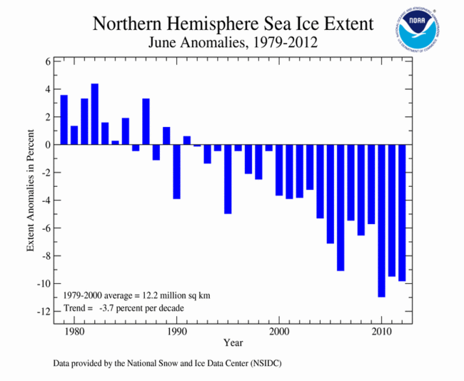
According to the National Snow and Ice Data Center (NSIDC), the Northern Hemisphere sea ice extent — which is measured from passive microwave instruments onboard NOAA satellites — averaged for June 2012 was 10.97 million square kilometers (4.24 million square miles), 9.83 percent below average. This ranked as the second smallest June sea ice extent on record for the Northern Hemisphere in the 1979-2012 period of record. During the month, the Arctic lost a total of 2.86 million square km (1.1 million square miles) of ice — over four times the area of Texas — marking the largest June ice loss in the satellite record. The last three Junes (2010-2012) have had the three smallest ice extents for the month, with June 2012 being the 21st consecutive June and the 133rd consecutive month with below-average Arctic sea ice extent. June Arctic sea ice has decreased at an average rate of 3.7 percent per decade.
According to analysis by the NSIDC, Arctic sea ice declined quickly in early June, setting record daily lows for a brief period in the middle of the month. Large amounts of ice were loss in the Kara, Bering, and Beaufort seas, as well as Hudson and Baffin bays. Slightly above-average sea ice was observed along the eastern Greenland coast.
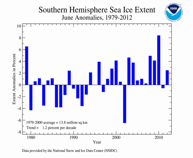
The June 2012 Southern Hemisphere sea ice extent was 14.18 million square km (5.5 million square miles), 2.48 percent above average, and the 10th largest (25th smallest) June sea ice extent in the 1979-2012 period of record. Antarctic sea ice extent has increased at an average rate of 1.2 percent per decade, with substantial interannual variability.
For further information on the Northern and Southern Hemisphere snow and ice conditions, please visit the NSIDC News page.