Issued: 15 January 2013
NH Snow Cover Extent
Snow Extent data were provided by the Global Snow Laboratory, Rutgers University. Period of record is 1966-2012 (47 years).
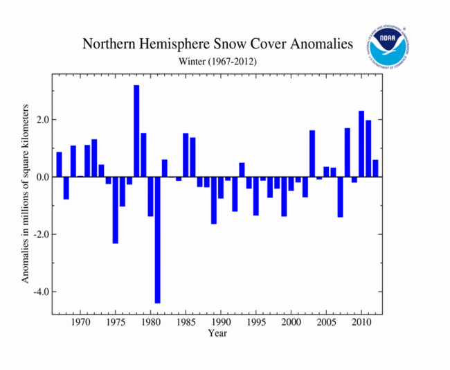
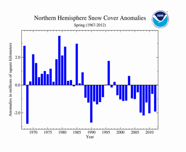
The timeseries to the right shows the mean Northern Hemisphere snow cover extent for winter (December-February) from 1967 through 2012. During the three month season in 2011/12, the Northern Hemisphere experienced its 14th largest (33rd smallest) snow cover extent on record at 590,000 square km (228,000 square miles) above the average of 45.2 million square km (17.5 million square miles). Northern Hemisphere winter snow cover extent has only changed slightly in the 47-year record, with a seasonal increase of about 0.1 percent per decade. By the spring season (March-May), the Northern Hemisphere snow cover extent contracted to a below-average extent for the time of year. The seasonal snow cover extent was 1.9 million square km (734,000 square miles) below the long-term average and ranked as the sixth smallest seasonal extent on record. Spring snow cover for the Northern Hemisphere is decreasing at an approximate rate of 2.2 percent per decade. More information on individual global snow and ice events during 2012 can be found in the Global Hazards report
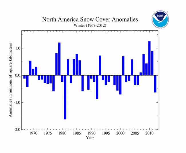
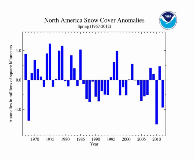
Across North America during the 2011/12 winter, snow was limited, and the seasonal snowfall extent was the fourth smallest on record for the continent at 630,000 square km (243,000 square miles) below the average of 17.2 million square km (6.6 million square miles). This was the smallest winter snow cover extent since the winter of 1999/2000 and in stark contrast to the past two winter seasons, 2009/10 and 2010/11, which had the largest and third largest snow extents, respectively. The below-average snow cover extent for North America continued into spring. The spring snow extent for North America was 930,000 square km (359,000 square miles) below average and the third smallest value on record. For more information on U.S. snow and ice during 2012, please see the U.S. Snow and Ice report.

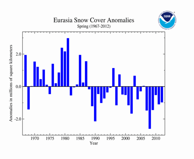
In Eurasia, snow cover extent during the 2011/12 winter was above average. The seasonal snow cover extent was 1.2 million square km (463,000 square miles) above the long-term average and ranked as the fourth largest on record, behind the winters of 1977/78, 2002/03, and 1971/72. By spring, the snow cover extent contracted to 1.0 million square km (386,000 square miles) below average and was the 12th smallest (35th largest) spring extent on record.
Sea Ice Extent
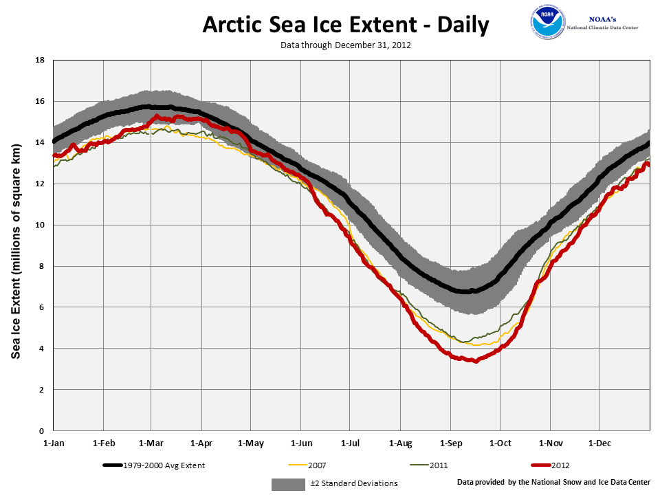
Arctic sea ice, which is measured from passive microwave instruments onboard NOAA satellites, usually expands during the cold season to a March maximum, and then contracts during the warm season to a September minimum. According to data from the National Snow and Ice Data Center (NSIDC), the maximum Arctic sea ice extent during 2012 occurred on March 18th, which was 12 days later than average. The annual maximum extent of 15.24 million square km (5.88 million square miles) was 614,000 square km (237,000 square miles) below the 1979-2000 average and the ninth lowest in the satellite record. The nine smallest annual Arctic sea ice maximum extents have occurred between 2004 and 2012. On March 18th, most of the Arctic had near to slightly-above average sea ice coverage, with the exception of the Barents and Kara Seas and the Gulf of St. Lawrence. The March 2012 monthly average Arctic sea ice extent was 15.21 million square kilometers (5.87 million square miles), 3.42 percent below the 1979-2000 long-term average, and the ninth smallest March ice extent on record. This was the largest March Arctic sea ice extent since 2008, and one of the largest of the last decade.
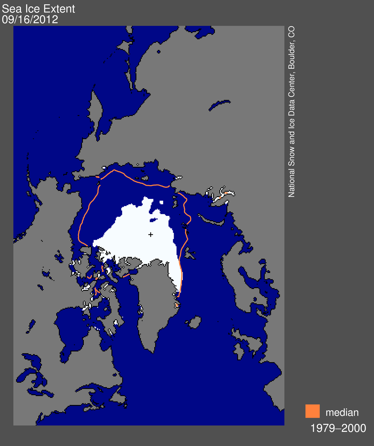
According to data from the NSIDC, on August 26th the Arctic sea ice extent dropped below the previous record low ice extent for the Arctic which occurred on September 18, 2007 at 4.17 million square km (1.61 million square miles). The sea ice continued shrinking until it dropped to 3.41 million square km (1.32 million square miles), reaching its annual minimum on September 16th. The 2012 annual minimum extent was 760,000 square kilometers (293,000 square miles) below the previous record minimum and 49 percent below the 1979-2000 average. During the Arctic sea ice melt season, between March 18th and September 16th, 11.83 million square kilometers (4.57 million square miles) of ice was lost. This marks the largest seasonal Arctic sea ice loss in the satellite record, surpassing the 10.65 million square km (4.11 million square miles) of ice loss during the 2008 melt season.
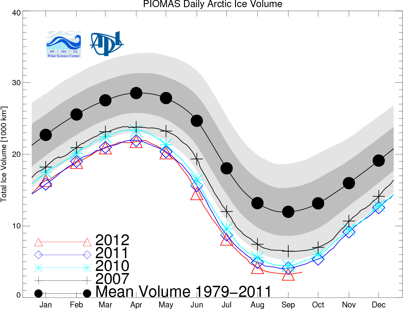
When using Arctic sea ice extent to monitor the state of sea ice conditions across the Arctic, no information is available on the thickness of the ice. To compensate for this, the Polar Science Center at the University of Washington developed a modeled dataset to measure the volume of Arctic sea ice using the Pan-Arctic Ice Ocean Modeling and Assimilation System (PIOMAS). Sea ice volume is an important climate indicator because it depends on both ice thickness and extent and therefore more directly tied to climate forcing than extent alone. According to this dataset, Arctic sea ice volume reached a monthly low value during September 2012, at 3,400 km3, the smallest monthly sea ice volume on record. The previous record small Arctic sea ice volume for September occurred in 2011 at 4,200 km3. The September 2012 value is 72 percent lower than the mean over the 1979-2011 period, 80 percent lower than the maximum in 1979, and 2.0 standard deviations below the 1979-2011 trend.

The Southern Hemisphere sea ice extent reached its annual maximum extent on September 26th at 19.44 million square km (7.51 million square miles). This marked the largest annual maximum extent of Antarctic sea ice extent on record and surpassed the previous record of 19.36 million square km (7.47 million square miles) which occurred on September 21, 2006.
Arctic summer sea ice is shrinking much more rapidly than the rate at which Antarctic winter sea ice is expanding. Over the 1979-2012 record, the Arctic has experienced significant ice loss, while the growth of Antarctic sea ice has been slight. The September 2012 record low Arctic sea ice extent was 6.2 standard deviations below its 1979-2000 average, while the record large Antarctic sea ice extent was 2.1 standard deviations above its 1979-2000 average. Differences in hemispheric weather patterns, ocean currents, and geography partially account for these differing sea ice trends. A more detailed description of these differences is available through the NSIDC.
For further information on the Northern and Southern Hemisphere snow and ice conditions, please visit the NSIDC News page.